

Waiheke Island Surf Guide
Waiheke Island in Auckland East Coast is a sheltered beach and reef break that only works when conditions are just right. Spring and Summer provide the best conditions. Offshore winds blow from the southwest. Tends to receive distant groundswells and the best swell direction is from the northeast. The beach breaks offer lefts and rights together with both left and right hand reef breaks offshore.. Best around high tide. Relatively few surfers here, even on good days. Watch out for rocks.
Waiheke Island Spot Info
| Type: | Rating: | Reliability: | Todays Sea Temp*: |
|---|---|---|---|
| inconsistent | 13.7°C*ocean temperature recorded from satellite |
Surfing Waiheke Island:
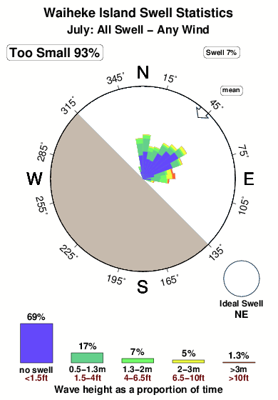
The best conditions reported for surf at Waiheke Island occur when a Northeast swell combines with an offshore wind direction from the Southwest.

Energía de Olas (poder): 12 horas


Waiheke Island Surf:
Thursday, 30 July 2026, 15:31 Local time| jueves 30 | vie | |||
| 3PM | 6PM | 9PM | 0AM | |
| Wave (m) | ||||
| Período (s) | 4 | 4 | 5 | 6 |
| Viento (km/h) | ||||
| Estado del Viento | cross- on |
cross- on |
cross- on |
cross- on |
- /breaks/Waiheke-Island/forecasts/latest
Waiheke Island Surf Guide
Waiheke Island in Auckland East Coast is a sheltered beach and reef break that only works when conditions are just right. Spring and Summer provide the best conditions. Offshore winds blow from the southwest. Tends to receive distant groundswells and the best swell direction is from the northeast. The beach breaks offer lefts and rights together with both left and right hand reef breaks offshore.. Best around high tide. Relatively few surfers here, even on good days. Watch out for rocks.
Waiheke Island Spot Info
Type: Rating: Reliability: Todays Sea Temp*:  Beach and reef
 2
2inconsistent 13.7°C*ocean temperature recorded from satelliteSurfing Waiheke Island:
The best conditions reported for surf at Waiheke Island occur when a Northeast swell combines with an offshore wind direction from the Southwest.
Energía de Olas (poder): 12 horas
Usa la barra de navegación de arriba para ver la temperatura del mar en Waiheke Island, fotografías Waiheke Island, previsiones detalladas de olas para Waiheke Island, vientos y previsión del tiempo, webcams para Waiheke Island, viento actual desde estaciones meteorológicas en Auckland y predicciones de marea para Waiheke Island. Las mapas de olas para New Zealand enseñarán un mapa grande de New Zealand y los mares que rodean. Los mapas de olas pueden ser animadas para mostrar diferentes componentes de olas, la altura de ola, la energía de ola, el período, junto con previsiones de viento y del tiempo. Previsiones actuales del tiempo y del estado del mar provienen de boyas marinas de New Zealand, del barcos que transitan en la zona y de estaciones meteorológicas costeras. Cada página de previsiones tiene un Busca-Olas Regional y Global para localizar las mejores condiciones para surfear en el área de Waiheke Island.
Waiheke Island Surf:
Thursday, 30 July 2026, 15:31 Local timejueves 30 vie 3PM 6PM 9PM 0AM Wave (m) Período (s) 4 4 5 6 Viento (km/h) Estado del Viento cross-
oncross-
oncross-
oncross-
on- /breaks/Waiheke-Island/forecasts/latest
- /breaks/Waiheke-Island/forecasts/latest/six_day
Waiheke Island Surf Guide
Waiheke Island in Auckland East Coast is a sheltered beach and reef break that only works when conditions are just right. Spring and Summer provide the best conditions. Offshore winds blow from the southwest. Tends to receive distant groundswells and the best swell direction is from the northeast. The beach breaks offer lefts and rights together with both left and right hand reef breaks offshore.. Best around high tide. Relatively few surfers here, even on good days. Watch out for rocks.
Waiheke Island Spot Info
Type: Rating: Reliability: Todays Sea Temp*: Beach and reef2inconsistent 13.7°C*ocean temperature recorded from satelliteSurfing Waiheke Island:
The best conditions reported for surf at Waiheke Island occur when a Northeast swell combines with an offshore wind direction from the Southwest.
Energía de Olas (poder): 12 horas
Usa la barra de navegación de arriba para ver la temperatura del mar en Waiheke Island, fotografías Waiheke Island, previsiones detalladas de olas para Waiheke Island, vientos y previsión del tiempo, webcams para Waiheke Island, viento actual desde estaciones meteorológicas en Auckland y predicciones de marea para Waiheke Island. Las mapas de olas para New Zealand enseñarán un mapa grande de New Zealand y los mares que rodean. Los mapas de olas pueden ser animadas para mostrar diferentes componentes de olas, la altura de ola, la energía de ola, el período, junto con previsiones de viento y del tiempo. Previsiones actuales del tiempo y del estado del mar provienen de boyas marinas de New Zealand, del barcos que transitan en la zona y de estaciones meteorológicas costeras. Cada página de previsiones tiene un Busca-Olas Regional y Global para localizar las mejores condiciones para surfear en el área de Waiheke Island.
Waiheke Island Surf:
Thursday, 30 July 2026, 15:31 Local timejueves 30 vie 3PM 6PM 9PM 0AM Wave (m) Período (s) 4 4 5 6 Viento (km/h) Estado del Viento cross-
oncross-
oncross-
oncross-
on- /breaks/Waiheke-Island/forecasts/latest
Waiheke Island Surf Guide
Waiheke Island in Auckland East Coast is a sheltered beach and reef break that only works when conditions are just right. Spring and Summer provide the best conditions. Offshore winds blow from the southwest. Tends to receive distant groundswells and the best swell direction is from the northeast. The beach breaks offer lefts and rights together with both left and right hand reef breaks offshore.. Best around high tide. Relatively few surfers here, even on good days. Watch out for rocks.
Waiheke Island Spot Info
Type: Rating: Reliability: Todays Sea Temp*: Beach and reef2inconsistent 13.7°C*ocean temperature recorded from satelliteSurfing Waiheke Island:
The best conditions reported for surf at Waiheke Island occur when a Northeast swell combines with an offshore wind direction from the Southwest.
Energía de Olas (poder): 12 horas
Usa la barra de navegación de arriba para ver la temperatura del mar en Waiheke Island, fotografías Waiheke Island, previsiones detalladas de olas para Waiheke Island, vientos y previsión del tiempo, webcams para Waiheke Island, viento actual desde estaciones meteorológicas en Auckland y predicciones de marea para Waiheke Island. Las mapas de olas para New Zealand enseñarán un mapa grande de New Zealand y los mares que rodean. Los mapas de olas pueden ser animadas para mostrar diferentes componentes de olas, la altura de ola, la energía de ola, el período, junto con previsiones de viento y del tiempo. Previsiones actuales del tiempo y del estado del mar provienen de boyas marinas de New Zealand, del barcos que transitan en la zona y de estaciones meteorológicas costeras. Cada página de previsiones tiene un Busca-Olas Regional y Global para localizar las mejores condiciones para surfear en el área de Waiheke Island.
Waiheke Island Surf:
Thursday, 30 July 2026, 15:31 Local timejueves 30 vie 3PM 6PM 9PM 0AM Wave (m) Período (s) 4 4 5 6 Viento (km/h) Estado del Viento cross-
oncross-
oncross-
oncross-
onTide Times:
Para Man O' War Bay, New Zealand, a %{dist} %{km} de %{location}.
PROXIMA ES A LAS (hora local) quedan marea alta marea baja Waiheke Island Tide Times and Tide Chart
Live Weather:
At Passage Rock Automatic Weather Station, 8 km from Waiheke Island.
moderate winds from the N
(km/h)
No weather reportAir temperature
-°COverall Waiheke Island Surf Consistency and Wind Distribution in julio
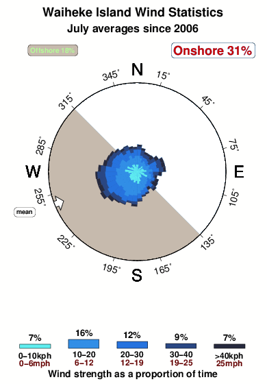


Wind stats for Waiheke Island: see the variation in direction and stength by month.
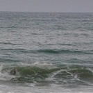
Fotos de Surf
de la galeríaContornos: Carreteras y Ríos: Selecciona un spot desde el menú 


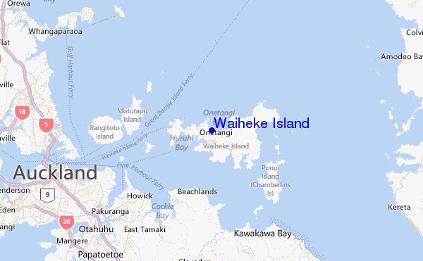
Usa este mapa para navegar hacia las playas de surf de Auckland y estaciones de marea cercanas de Waiheke Island
Spots de Surf más cercanos a Waiheke Island:
(Clica la ubicación para más detalles)- Closest spot16 mi
- Second closest spot16 mi
- Third closest spot17 mi
- Fourth closest spot18 mi
- Fifth closest spot19 mi
Boyas marinas más cercanas a Waiheke Island:
- Closest Boya Marinas69 mi
- Second closest Boya Marinas106 mi
- Third closest Boya Marinas293 mi
- Fourth closest Boya Marinas308 mi
- Fifth closest Boya Marinas324 mi
Estaciones de marea más cercanas a Waiheke Island:
- Closest estación de mareaMan O' War Bay4 mi
- Second closest estación de mareaMatiatia Bay5 mi
- Third closest estación de mareaManukau17 mi
- Fourth closest estación de mareaTiritiri Matangi Island17 mi
- Fifth closest estación de mareaAuckland17 mi
Airports
- The closest passenger airport to Waiheke Island is Auckland International Airport (AKL) in New Zealand, 35 km (22 miles) away (directly).
- The second nearest airport to Waiheke Island is Hamilton Airport (HLZ), also in New Zealand, 122 km (76 miles) away.
- Third is Whangarei Airport (WRE) in New Zealand, 130 km (81 miles) away.
- Tauranga Airport (TRG) in New Zealand is 140 km (87 miles) away.
- Rotorua Airport (ROT), also in New Zealand is the fifth nearest airport to Waiheke Island and is 184 km (114 miles) away.

- /breaks/Waiheke-Island/forecasts/latest


 Nearest