

- Forecast
- Maps
- Live
- Weather State
- Spot Information
Trestrignel Surf Forecast
/ Brittany – Cote d'Armor (9 surf breaks) /
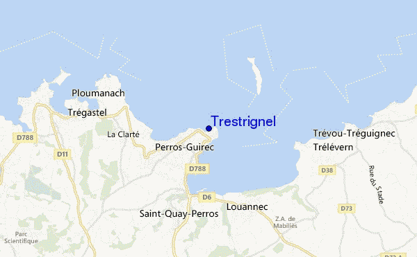
Trestrignel surf Forecast / Brittany – Cote d'Armor / France
- Map Icons:
 Break
Break Live Wave Height (m)
 Live Wind Speed (km/h)
 Surf Rating (10 Max)
 Ocean Swells (m)
- Wind Speed (km/h)
How big are the waves at Trestrignel today?
The current surf forecast for Trestrignel at 10AM is: 0.5m 13s primary swell from a West direction and 0.5m 8s secondary swell from a West direction, 0.3m 2s secondary swell from a West-southwest direction (forecast issued at 07:00am May 12). The wind direction is predicted to be cross-shore.
| Time (CEST) & Date | Wave Height | Wave Period |
|---|---|---|
| Morning (12 May) | 1ft (0.3m) | 14s |
| Afternoon (12 May) | 2.5ft (0.7m) | 13s |
| Evening (12 May) | 4.5ft (1.3m) | 14s |
Table - waves today at Trestrignel. (Swell directed towards the surf break)
Sunday 12 | Monday 13 | Tuesday 14 | Wednesday 15 | Thursday 16 | Friday 17 | Saturday 18 | Sunday 19 | |||||||||||||||||||||||||||||||||||||||||||||||||||||
| 5 AM | 8 AM | 11 AM | 2 PM | 5 PM | 8 PM | 11 PM | 2 AM | 5 AM | 8 AM | 11 AM | 2 PM | 5 PM | 8 PM | 11 PM | 2 AM | 5 AM | 8 AM | 11 AM | 2 PM | 5 PM | 8 PM | 11 PM | 2 AM | 5 AM | 8 AM | 11 AM | 2 PM | 5 PM | 8 PM | 11 PM | 2 AM | 5 AM | 8 AM | 11 AM | 2 PM | 5 PM | 8 PM | 11 PM | 2 AM | 5 AM | 8 AM | 11 AM | 2 PM | 5 PM | 8 PM | 11 PM | 2 AM | 5 AM | 8 AM | 11 AM | 2 PM | 5 PM | 8 PM | 11 PM | 2 AM | 5 AM | 8 AM | 11 AM | 2 PM | |
Rating (10 max) | ||||||||||||||||||||||||||||||||||||||||||||||||||||||||||||
Swell Height Map |    |    |    |    |    |    |   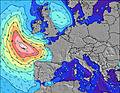 | 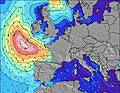 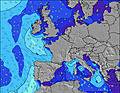 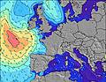 | ||||||||||||||||||||||||||||||||||||||||||||||||||||
| Wave Height (m) & direction (?) | ||||||||||||||||||||||||||||||||||||||||||||||||||||||||||||
| Period(s) (?) | 8 | 14 | 13 | 13 | 12 | 14 | 13 | 13 | 13 | 12 | 12 | 12 | 12 | 12 | 11 | 11 | 11 | 11 | 12 | 12 | 12 | 12 | 12 | 12 | 12 | 12 | 12 | 11 | 11 | 11 | 11 | 11 | 10 | 10 | 10 | 10 | 9 | 9 | 8 | 8 | 8 | 8 | 8 | 8 | 9 | 9 | 9 | 9 | 9 | 9 | 9 | 9 | 9 | 9 | 9 | 9 | 8 | 8 | 9 | 8 |
Wave (?)Graph | ||||||||||||||||||||||||||||||||||||||||||||||||||||||||||||
| Energy (?) | 37 | 40 | 92 | 178 | 205 | 714 | 722 | 775 | 740 | 657 | 628 | 538 | 336 | 583 | 515 | 566 | 898 | 1655 | 1901 | 2377 | 2499 | 2338 | 1923 | 1652 | 1688 | 1419 | 1419 | 1371 | 1300 | 1253 | 1148 | 918 | 679 | 716 | 761 | 782 | 614 | 461 | 400 | 339 | 247 | 163 | 111 | 93 | 162 | 173 | 141 | 138 | 138 | 141 | 141 | 138 | 138 | 149 | 140 | 99 | 94 | 103 | 77 | 75 |
Wind (km/h) | ||||||||||||||||||||||||||||||||||||||||||||||||||||||||||||
| Wind State (?) onshore cross-onshore cross-shore cross-offshore offshore glassy | cross | cross | cross | cross- on | cross- on | cross- on | cross | cross- off | cross- off | off | off | cross- off | cross | cross- off | cross- off | off | cross- off | cross- off | cross- off | cross- off | cross- off | cross- off | off | off | off | off | off | off | off | off | cross- off | cross- off | cross- off | cross- off | cross- off | cross- off | cross- off | cross- off | cross- off | cross- off | cross- off | cross | cross | cross | cross- on | on | cross- on | cross- on | cross- on | glass | glass | cross- on | cross- on | cross- on | cross- on | cross- on | cross- on | cross- on | cross- on | cross- on |
High Tide / height (m) | 10:08AM 6.70 | 10:24PM 6.69 | 10:53AM 6.15 | 11:12PM 6.17 | 11:47AM 5.65 | 12:10AM 5.71 | 12:54PM 5.27 | 1:22AM 5.41 | 2:14PM 5.15 | 2:40AM 5.35 | 3:27PM 5.28 | 3:47AM 5.52 | 4:24PM 5.58 | 4:40AM 5.80 | ||||||||||||||||||||||||||||||||||||||||||||||
Low Tide / height (m) | 4:06AM 0.68 | 4:23PM 1.19 | 4:50AM 1.24 | 5:07PM 1.75 | 5:38AM 1.80 | 5:57PM 2.27 | 6:36AM 2.27 | 7:00PM 2.66 | 7:49AM 2.54 | 8:21PM 2.81 | 9:09AM 2.52 | 9:40PM 2.67 | 10:15AM 2.28 | 10:39PM 2.34 | 11:03AM 1.95 | |||||||||||||||||||||||||||||||||||||||||||||
Sunday 12 | Monday 13 | Tuesday 14 | Wednesday 15 | Thursday 16 | Friday 17 | Saturday 18 | Sunday 19 | |||||||||||||||||||||||||||||||||||||||||||||||||||||
| Sunrise | - | 6:35 | - | - | - | - | - | - | - | 6:33 | - | - | - | - | - | - | - | 6:33 | - | - | - | - | - | - | - | 6:31 | - | - | - | - | - | - | - | 6:30 | - | - | - | - | - | - | - | 6:28 | - | - | - | - | - | - | - | 6:26 | - | - | - | - | - | - | - | 6:26 | - | - |
| Sunset | - | - | - | - | - | 9:45 | - | - | - | - | - | - | - | 9:45 | - | - | - | - | - | - | - | 9:47 | - | - | - | - | - | - | - | 9:49 | - | - | - | - | - | - | - | 9:50 | - | - | - | - | - | - | - | 9:52 | - | - | - | - | - | - | - | 9:52 | - | - | - | - | - | - |
Rain (mm) | - | 1 | - | - | - | - | - | - | - | - | 1 | 2 | 3 | 1 | - | - | - | - | - | - | - | - | - | - | - | - | - | 1 | 2 | 1 | - | - | - | 1 | - | 1 | 2 | 1 | - | - | - | - | - | - | - | - | - | 1 | - | - | - | - | - | - | - | - | - | 1 | - | - |
| Temp. °C | 17 | 15 | 16 | 16 | 15 | 13 | 12 | 10 | 10 | 12 | 15 | 15 | 13 | 14 | 12 | 11 | 12 | 13 | 14 | 15 | 15 | 14 | 13 | 12 | 11 | 12 | 15 | 15 | 15 | 14 | 12 | 12 | 11 | 12 | 14 | 14 | 15 | 15 | 13 | 12 | 11 | 12 | 14 | 14 | 15 | 14 | 14 | 13 | 13 | 13 | 14 | 13 | 13 | 13 | 12 | 12 | 13 | 13 | 13 | 14 |
| Feels °C (?) | 16 | 13 | 14 | 13 | 11 | 9 | 9 | 7 | 7 | 7 | 10 | 10 | 9 | 11 | 8 | 6 | 7 | 7 | 8 | 8 | 8 | 9 | 8 | 7 | 7 | 8 | 10 | 9 | 11 | 10 | 8 | 7 | 6 | 8 | 10 | 10 | 12 | 12 | 10 | 9 | 8 | 9 | 11 | 11 | 12 | 12 | 12 | 12 | 12 | 13 | 14 | 12 | 11 | 11 | 10 | 11 | 12 | 12 | 10 | 11 |
FREE! Surf-Forecast.com widget for your website
The surf report / weather widget below is available to embed on third party websites free of charge and provides a summary of our Trestrignel surf forecast. Simply grab the html code snippet that we provide and paste it into your own site. You can choose your preferred language and metric/imperial units for the surf forecast feed to suit users of your site. Click here to get the code.


 Nearest