
The Peak Surf Guide
The Peak in Donegal is an exposed reef break that has quite consistent surf and can work at any time of the year. Works best in offshore winds from the southeast. Waves just as likely from local windswells as from distant groundswells and the optimum swell angle is from the west. Reef breaks provide lefts and rights. Best around low tide. Sometimes crowded.
The Peak Spot Info
| Type: | Rating: | Reliability: | Todays Sea Temp*: |
|---|---|---|---|
| fairly consistent | 16.4°C*ocean temperature recorded from satellite |
Surfing The Peak:
The best conditions reported for surf at The Peak occur when a West swell combines with an offshore wind direction from the Southeast.
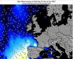
Energía de Olas (poder): 12 horas


The Peak Surf:
Thursday, 30 July 2026, 08:29 Local time| jueves 30 | ||||
| 4AM | 7AM | 10AM | 1PM | |
| Wave (m) | ||||
| Período (s) | 7 | 8 | 8 | 8 |
| Viento (km/h) | ||||
| Estado del Viento | on | cross- on |
cross- on |
cross- on |
- /breaks/The-Peak_1/forecasts/latest

The Peak Surf Guide
The Peak in Donegal is an exposed reef break that has quite consistent surf and can work at any time of the year. Works best in offshore winds from the southeast. Waves just as likely from local windswells as from distant groundswells and the optimum swell angle is from the west. Reef breaks provide lefts and rights. Best around low tide. Sometimes crowded.
The Peak Spot Info
Type: Rating: Reliability: Todays Sea Temp*:  Reef
Reef 3
3fairly consistent 16.4°C*ocean temperature recorded from satelliteSurfing The Peak:
The best conditions reported for surf at The Peak occur when a West swell combines with an offshore wind direction from the Southeast.
Energía de Olas (poder): 12 horas
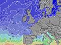
Usa la barra de navegación de arriba para ver la temperatura del mar en The Peak, fotografías The Peak, previsiones detalladas de olas para The Peak, vientos y previsión del tiempo, webcams para The Peak, viento actual desde estaciones meteorológicas en Donegal y predicciones de marea para The Peak. Las mapas de olas para Ireland enseñarán un mapa grande de Ireland y los mares que rodean. Los mapas de olas pueden ser animadas para mostrar diferentes componentes de olas, la altura de ola, la energía de ola, el período, junto con previsiones de viento y del tiempo. Previsiones actuales del tiempo y del estado del mar provienen de boyas marinas de Ireland, del barcos que transitan en la zona y de estaciones meteorológicas costeras. Cada página de previsiones tiene un Busca-Olas Regional y Global para localizar las mejores condiciones para surfear en el área de The Peak.
The Peak Surf:
Thursday, 30 July 2026, 08:29 Local timejueves 30 4AM 7AM 10AM 1PM Wave (m) Período (s) 7 8 8 8 Viento (km/h) Estado del Viento on cross-
oncross-
oncross-
on- /breaks/The-Peak_1/forecasts/latest
- /breaks/The-Peak_1/forecasts/latest/six_day
The Peak Surf Guide
The Peak in Donegal is an exposed reef break that has quite consistent surf and can work at any time of the year. Works best in offshore winds from the southeast. Waves just as likely from local windswells as from distant groundswells and the optimum swell angle is from the west. Reef breaks provide lefts and rights. Best around low tide. Sometimes crowded.
The Peak Spot Info
Type: Rating: Reliability: Todays Sea Temp*: Reef3fairly consistent 16.4°C*ocean temperature recorded from satelliteSurfing The Peak:
The best conditions reported for surf at The Peak occur when a West swell combines with an offshore wind direction from the Southeast.
Energía de Olas (poder): 12 horas
Usa la barra de navegación de arriba para ver la temperatura del mar en The Peak, fotografías The Peak, previsiones detalladas de olas para The Peak, vientos y previsión del tiempo, webcams para The Peak, viento actual desde estaciones meteorológicas en Donegal y predicciones de marea para The Peak. Las mapas de olas para Ireland enseñarán un mapa grande de Ireland y los mares que rodean. Los mapas de olas pueden ser animadas para mostrar diferentes componentes de olas, la altura de ola, la energía de ola, el período, junto con previsiones de viento y del tiempo. Previsiones actuales del tiempo y del estado del mar provienen de boyas marinas de Ireland, del barcos que transitan en la zona y de estaciones meteorológicas costeras. Cada página de previsiones tiene un Busca-Olas Regional y Global para localizar las mejores condiciones para surfear en el área de The Peak.
The Peak Surf:
Thursday, 30 July 2026, 08:29 Local timejueves 30 4AM 7AM 10AM 1PM Wave (m) Período (s) 7 8 8 8 Viento (km/h) Estado del Viento on cross-
oncross-
oncross-
on- /breaks/The-Peak_1/forecasts/latest
The Peak Surf Guide
The Peak in Donegal is an exposed reef break that has quite consistent surf and can work at any time of the year. Works best in offshore winds from the southeast. Waves just as likely from local windswells as from distant groundswells and the optimum swell angle is from the west. Reef breaks provide lefts and rights. Best around low tide. Sometimes crowded.
The Peak Spot Info
Type: Rating: Reliability: Todays Sea Temp*: Reef3fairly consistent 16.4°C*ocean temperature recorded from satelliteSurfing The Peak:
The best conditions reported for surf at The Peak occur when a West swell combines with an offshore wind direction from the Southeast.
Energía de Olas (poder): 12 horas
Usa la barra de navegación de arriba para ver la temperatura del mar en The Peak, fotografías The Peak, previsiones detalladas de olas para The Peak, vientos y previsión del tiempo, webcams para The Peak, viento actual desde estaciones meteorológicas en Donegal y predicciones de marea para The Peak. Las mapas de olas para Ireland enseñarán un mapa grande de Ireland y los mares que rodean. Los mapas de olas pueden ser animadas para mostrar diferentes componentes de olas, la altura de ola, la energía de ola, el período, junto con previsiones de viento y del tiempo. Previsiones actuales del tiempo y del estado del mar provienen de boyas marinas de Ireland, del barcos que transitan en la zona y de estaciones meteorológicas costeras. Cada página de previsiones tiene un Busca-Olas Regional y Global para localizar las mejores condiciones para surfear en el área de The Peak.
The Peak Surf:
Thursday, 30 July 2026, 08:29 Local timejueves 30 4AM 7AM 10AM 1PM Wave (m) Período (s) 7 8 8 8 Viento (km/h) Estado del Viento on cross-
oncross-
oncross-
onTide Times:
Para Bundoran, a %{dist} %{km} de %{location}.
PROXIMA ES A LAS (hora local) quedan marea alta marea baja The Peak Tide Times and Tide Chart
Live Weather:
At Finner, 3 km from The Peak.
wind obs. (11 kph from 210 degs) was rejected
(km/h)
no reportAir temperature
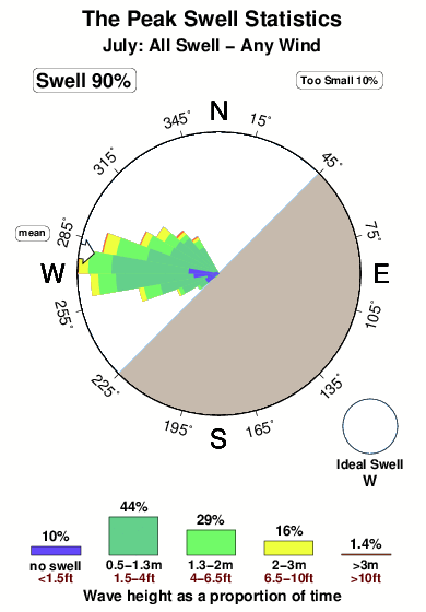
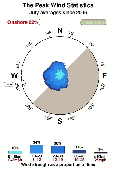
15.2°COverall The Peak Surf Consistency and Wind Distribution in julio
Fotos de Surf
de la galeríaContornos: Carreteras y Ríos: Selecciona un spot desde el menú 


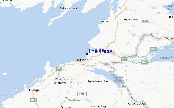
Usa este mapa para navegar hacia las playas de surf de Donegal y estaciones de marea cercanas de The Peak
Spots de Surf más cercanos a The Peak:
(Clica la ubicación para más detalles)- Closest spot1 mi
- Second closest spot1 mi
- Third closest spot2 mi
- Fourth closest spot2 mi
- Fifth closest spot6 mi
Boyas marinas más cercanas a The Peak:
- Closest Boya Marinas53 mi
- Second closest Boya Marinas77 mi
- Third closest Boya Marinas78 mi
- Fourth closest Boya Marinas82 mi
- Fifth closest Boya Marinas96 mi
Estaciones de marea más cercanas a The Peak:
- Closest estación de mareaLondonderry52 mi
- Second closest estación de mareaBun Cranncha55 mi
- Third closest estación de mareaWestport70 mi
- Fourth closest estación de mareaPortstewart78 mi
- Fifth closest estación de mareaPortrush81 mi
Airports
- The closest passenger airport to The Peak is Sligo Airport (SXL) in Ireland, 32 km (20 miles) away (directly).
- The second nearest airport to The Peak is St Angelo (Enniskillen) Airport (ENK) in England, 42 km (26 miles) away.
- Third is Connaught Airport (NOC) in Ireland, 74 km (46 miles) away.
- Londonderry Eglinton Airport (LDY) in North Ireland is 94 km (58 miles) away.
- Aldergrove (Belfast) Airport (BFS), also in North Ireland is the fifth nearest airport to The Peak and is 134 km (83 miles) away.

- /breaks/The-Peak_1/forecasts/latest


 Nearest