- Forecast
- Maps
- Live
- Weather State
- Spot Information
Souillac Previsión de Olas
/ Mauritius (25 surf breaks) /Previsiones:

Surf en SouillacPronóstico / Mauritius / Mauritius
Actualizacion del pronostico en hora min s Forecast update imminent
La altura de oleaje para Souillac es en mar abierto. Olas rompiendo en la orilla/arrecife son usualmente más pequeñas en áreas protegidas.
La temperatura del mar en Souillac hoy es
28.4° C
(Lo cual es ligeramente más cálido de lo habitual)Actualizaciones en hora min s Forecast update imminent
martes 17 | miércoles 18 | jueves 19 | vie 20 | |||||||||||||||||||||
| 7 AM | 10 AM | 1 PM | 4 PM | 7 PM | 10 PM | 1 AM | 4 AM | 7 AM | 10 AM | 1 PM | 4 PM | 7 PM | 10 PM | 1 AM | 4 AM | 7 AM | 10 AM | 1 PM | 4 PM | 7 PM | 10 PM | 1 AM | 4 AM | |
Notación (10 max) | ||||||||||||||||||||||||
Mapa de Altura de Olas |  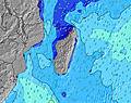 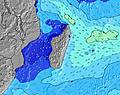 | 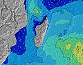 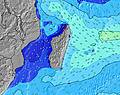 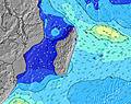 | 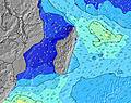 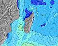 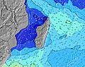 | 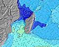 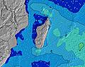 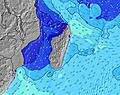 | ||||||||||||||||||||
| Altura de Olas (m) & dirección (?) | ||||||||||||||||||||||||
| Período(s) (?) | 14 | 14 | 14 | 14 | 14 | 14 | 14 | 13 | 13 | 13 | 13 | 13 | 13 | 13 | 13 | 13 | 13 | 13 | 13 | 9 | 9 | 9 | 9 | 9 |
Gráfico (?)Olas | ||||||||||||||||||||||||
| 1079 | 1064 | 1079 | 1079 | 1064 | 1115 | 1036 | 933 | 834 | 821 | 680 | 680 | 669 | 535 | 424 | 424 | 424 | 340 | 340 | 372 | 421 | 421 | 372 | 363 | |
Viento (km/h) | ||||||||||||||||||||||||
| Estado del Viento (?) onshore Viento de Mar-Cruzado Cruzado Viento de Tierra-Cruzado Viento de Tierra Cristalino | cross- off | cross- off | cross- off | cross- off | cross- off | cross- off | cross- off | cross- off | cross- off | cross- off | cross | cross | cross- off | cross- off | cross- off | cross- off | cross- off | cross- off | cross- off | cross- off | cross- off | cross- off | cross- off | cross- off |
Marea alta / altura (m) | 12:45PM 0.85 | 1:17AM 0.80 | 1:13PM 0.88 | 1:42AM 0.83 | 1:42PM 0.87 | 2:09AM 0.84 | ||||||||||||||||||
Marea baja / altura (m) | 6:43AM 0.13 | 7:07PM -0.01 | 7:11AM 0.10 | 7:33PM -0.02 | 7:40AM 0.08 | 7:59PM 0.00 | ||||||||||||||||||
martes 17 | miércoles 18 | jueves 19 | vie 20 | |||||||||||||||||||||
| Amanecer | 6:01 | - | - | - | - | - | - | - | 6:01 | - | - | - | - | - | - | - | 6:01 | - | - | - | - | - | - | - |
| Puesta del Sol | - | - | - | 6:45 | - | - | - | - | - | - | - | 6:45 | - | - | - | - | - | - | - | 6:44 | - | - | - | - |
Lluvia (mm) | - | - | - | - | - | - | - | - | - | - | 2 | 2 | - | - | - | - | - | - | - | 1 | - | - | - | - |
| Temp. °C | 26 | 28 | 29 | 28 | 27 | 26 | 26 | 26 | 26 | 27 | 28 | 27 | 27 | 26 | 26 | 25 | 25 | 27 | 28 | 28 | 26 | 26 | 25 | 25 |
| Feels °C (?) | 28 | 29 | 29 | 28 | 29 | 27 | 28 | 28 | 28 | 28 | 29 | 27 | 28 | 27 | 27 | 26 | 26 | 27 | 28 | 28 | 27 | 27 | 26 | 27 |
- Map Icons:
 Break
Break Live Wave Height (m)
 Live Wind Speed (km/h)
 Surf Rating (10 Max)
 Ocean Swells (m)
- Wind Speed (km/h)
GRÁTIS! Un widget de Surf-Forecast.com para tu sitio
Este widget grátis de previsiones de surf y tiempo puede ser añadido a cualquier otro sitio y da un resumen de previsiones de olas para Souillac. Solo necesita cortar y pegar el código HTML de abajo en su web. Puede elegir preferencias de idioma y de unidades (métricas o imperiales) para convenir a los usuarios de su sitio. Clica aquí para obtener el código.
 Nearest