
Smith River and Kellogg Rd Surf Guide
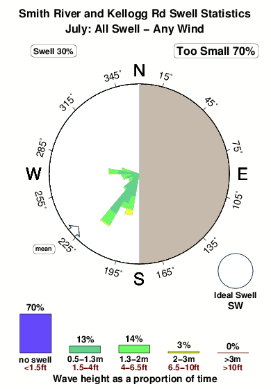
Smith River and Kellogg Road Area in Del Norte County is an exposed beach break that has inconsistent surf with no particular seasonal pattern. Offshore winds are from the east. Clean groundswells prevail and the best swell direction is from the southwest. The beach break provides left and right handers. Surfable at all stages of the tide. It very rarely gets crowded here. Watch out for sharks.
Smith River and Kellogg Rd Spot Info
| Type: | Rating: | Reliability: | Todays Sea Temp*: |
|---|---|---|---|
| inconsistent | 15.0°C*ocean temperature recorded from satellite |
Surfing Smith River and Kellogg Rd:
The best conditions reported for surf at Smith River and Kellogg Rd occur when a Southwest swell combines with an offshore wind direction from the East.

Energía de Olas (poder): 12 horas


Smith River and Kellogg Rd Surf:
Thursday, 30 July 2026, 17:11 Local time| jueves 30 | ||||
| 2PM | 5PM | 8PM | 11PM | |
| Wave (m) | ||||
| Período (s) | 16 | 16 | 16 | 15 |
| Viento (km/h) | ||||
| Estado del Viento | cross- on |
cross- on |
cross- on |
off |
- /breaks/Smith-River-and-Kellogg-Road-Area/forecasts/latest
Smith River and Kellogg Rd Surf Guide
Smith River and Kellogg Road Area in Del Norte County is an exposed beach break that has inconsistent surf with no particular seasonal pattern. Offshore winds are from the east. Clean groundswells prevail and the best swell direction is from the southwest. The beach break provides left and right handers. Surfable at all stages of the tide. It very rarely gets crowded here. Watch out for sharks.
Smith River and Kellogg Rd Spot Info
Type: Rating: Reliability: Todays Sea Temp*:  Beach
Beach 2
2inconsistent 15.0°C*ocean temperature recorded from satelliteSurfing Smith River and Kellogg Rd:
The best conditions reported for surf at Smith River and Kellogg Rd occur when a Southwest swell combines with an offshore wind direction from the East.
Energía de Olas (poder): 12 horas
Usa la barra de navegación de arriba para ver la temperatura del mar en Smith River and Kellogg Rd, fotografías Smith River and Kellogg Rd, previsiones detalladas de olas para Smith River and Kellogg Rd, vientos y previsión del tiempo, webcams para Smith River and Kellogg Rd, viento actual desde estaciones meteorológicas en CAL - Del Norte County y predicciones de marea para Smith River and Kellogg Rd. Las mapas de olas para United States enseñarán un mapa grande de United States y los mares que rodean. Los mapas de olas pueden ser animadas para mostrar diferentes componentes de olas, la altura de ola, la energía de ola, el período, junto con previsiones de viento y del tiempo. Previsiones actuales del tiempo y del estado del mar provienen de boyas marinas de United States, del barcos que transitan en la zona y de estaciones meteorológicas costeras. Cada página de previsiones tiene un Busca-Olas Regional y Global para localizar las mejores condiciones para surfear en el área de Smith River and Kellogg Rd.
Smith River and Kellogg Rd Surf:
Thursday, 30 July 2026, 17:11 Local timejueves 30 2PM 5PM 8PM 11PM Wave (m) Período (s) 16 16 16 15 Viento (km/h) Estado del Viento cross-
oncross-
oncross-
onoff - /breaks/Smith-River-and-Kellogg-Road-Area/forecasts/latest
- /breaks/Smith-River-and-Kellogg-Road-Area/forecasts/latest/six_day
Smith River and Kellogg Rd Surf Guide
Smith River and Kellogg Road Area in Del Norte County is an exposed beach break that has inconsistent surf with no particular seasonal pattern. Offshore winds are from the east. Clean groundswells prevail and the best swell direction is from the southwest. The beach break provides left and right handers. Surfable at all stages of the tide. It very rarely gets crowded here. Watch out for sharks.
Smith River and Kellogg Rd Spot Info
Type: Rating: Reliability: Todays Sea Temp*: Beach2inconsistent 15.0°C*ocean temperature recorded from satelliteSurfing Smith River and Kellogg Rd:
The best conditions reported for surf at Smith River and Kellogg Rd occur when a Southwest swell combines with an offshore wind direction from the East.
Energía de Olas (poder): 12 horas
Usa la barra de navegación de arriba para ver la temperatura del mar en Smith River and Kellogg Rd, fotografías Smith River and Kellogg Rd, previsiones detalladas de olas para Smith River and Kellogg Rd, vientos y previsión del tiempo, webcams para Smith River and Kellogg Rd, viento actual desde estaciones meteorológicas en CAL - Del Norte County y predicciones de marea para Smith River and Kellogg Rd. Las mapas de olas para United States enseñarán un mapa grande de United States y los mares que rodean. Los mapas de olas pueden ser animadas para mostrar diferentes componentes de olas, la altura de ola, la energía de ola, el período, junto con previsiones de viento y del tiempo. Previsiones actuales del tiempo y del estado del mar provienen de boyas marinas de United States, del barcos que transitan en la zona y de estaciones meteorológicas costeras. Cada página de previsiones tiene un Busca-Olas Regional y Global para localizar las mejores condiciones para surfear en el área de Smith River and Kellogg Rd.
Smith River and Kellogg Rd Surf:
Thursday, 30 July 2026, 17:11 Local timejueves 30 2PM 5PM 8PM 11PM Wave (m) Período (s) 16 16 16 15 Viento (km/h) Estado del Viento cross-
oncross-
oncross-
onoff - /breaks/Smith-River-and-Kellogg-Road-Area/forecasts/latest
Smith River and Kellogg Rd Surf Guide
Smith River and Kellogg Road Area in Del Norte County is an exposed beach break that has inconsistent surf with no particular seasonal pattern. Offshore winds are from the east. Clean groundswells prevail and the best swell direction is from the southwest. The beach break provides left and right handers. Surfable at all stages of the tide. It very rarely gets crowded here. Watch out for sharks.
Smith River and Kellogg Rd Spot Info
Type: Rating: Reliability: Todays Sea Temp*: Beach2inconsistent 15.0°C*ocean temperature recorded from satelliteSurfing Smith River and Kellogg Rd:
The best conditions reported for surf at Smith River and Kellogg Rd occur when a Southwest swell combines with an offshore wind direction from the East.
Energía de Olas (poder): 12 horas
Usa la barra de navegación de arriba para ver la temperatura del mar en Smith River and Kellogg Rd, fotografías Smith River and Kellogg Rd, previsiones detalladas de olas para Smith River and Kellogg Rd, vientos y previsión del tiempo, webcams para Smith River and Kellogg Rd, viento actual desde estaciones meteorológicas en CAL - Del Norte County y predicciones de marea para Smith River and Kellogg Rd. Las mapas de olas para United States enseñarán un mapa grande de United States y los mares que rodean. Los mapas de olas pueden ser animadas para mostrar diferentes componentes de olas, la altura de ola, la energía de ola, el período, junto con previsiones de viento y del tiempo. Previsiones actuales del tiempo y del estado del mar provienen de boyas marinas de United States, del barcos que transitan en la zona y de estaciones meteorológicas costeras. Cada página de previsiones tiene un Busca-Olas Regional y Global para localizar las mejores condiciones para surfear en el área de Smith River and Kellogg Rd.
Smith River and Kellogg Rd Surf:
Thursday, 30 July 2026, 17:11 Local timejueves 30 2PM 5PM 8PM 11PM Wave (m) Período (s) 16 16 16 15 Viento (km/h) Estado del Viento cross-
oncross-
oncross-
onoff Tide Times:
En Smith River and Kellogg Rd (0 km).
PROXIMA ES A LAS (hora local) quedan marea alta marea baja Smith River and Kellogg Rd Tide Times and Tide Chart
Live Weather:
At Crescent City Airport, 16 km from Smith River and Kellogg Rd.
light winds from the NNW
(km/h)
ClearAir temperature
17.2°COverall Smith River and Kellogg Rd Surf Consistency and Wind Distribution in julio
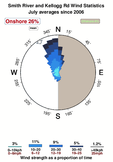


Wind stats for Smith River and Kellogg Rd: see the variation in direction and stength by month.
Fotos de Surf
de la galeríaContornos: Carreteras y Ríos: Selecciona un spot desde el menú 


Usa este mapa para navegar hacia las playas de surf de CAL - Del Norte County y estaciones de marea cercanas de Smith River and Kellogg Rd
Spots de Surf más cercanos a Smith River and Kellogg Rd:
(Clica la ubicación para más detalles)- Closest spot9 mi
- Second closest spot9 mi
- Third closest spot10 mi
- Fourth closest spot10 mi
- Fifth closest spot12 mi
Boyas marinas más cercanas a Smith River and Kellogg Rd:
- Closest Boya Marinas10 mi
- Second closest Boya Marinas66 mi
- Third closest Boya Marinas71 mi
- Fourth closest Boya Marinas83 mi
- Fifth closest Boya Marinas115 mi
Estaciones de marea más cercanas a Smith River and Kellogg Rd:
- Closest estación de mareaBrookings, Chetco Cove10 mi
- Second closest estación de mareaCrescent City12 mi
- Third closest estación de mareaWedderburn, Rogue River37 mi
- Fourth closest estación de mareaPort Orford59 mi
- Fifth closest estación de mareaTrinidad Harbor60 mi
Airports
- The nearest passenger airport to Smith River and Kellogg Rd is Chico Muni Airport (CIC) in USA, which is 307 km (191 miles) away (directly).
- The second closest airport to Smith River and Kellogg Rd is Mc Minnville Muni (Mackminnville) Airport (MMV), also in USA, 375 km (233 miles) away.

- /breaks/Smith-River-and-Kellogg-Road-Area/forecasts/latest


 Nearest