- Forecast
- Maps
- Live
- Weather State
- Spot Information
Shingles Previsión de Olas
/ West Coast South Island (21 surf breaks) /Previsiones:

Surf en ShinglesPronóstico / West Coast South Island / New Zealand
Actualizacion del pronostico en hora min s Forecast update imminent
La altura de oleaje para Shingles es en mar abierto. Olas rompiendo en la orilla/arrecife son usualmente más pequeñas en áreas protegidas.
La temperatura del mar en Shingles hoy es
17.4° C
(Lo cual es ligeramente más cálido de lo habitual)Actualizaciones en hora min s Forecast update imminent
sábado 28 | domingo 29 | lunes 30 | martes 31 | |||||||||||||||||||||
| 4 PM | 7 PM | 10 PM | 1 AM | 4 AM | 7 AM | 10 AM | 1 PM | 4 PM | 7 PM | 10 PM | 1 AM | 4 AM | 7 AM | 10 AM | 1 PM | 4 PM | 7 PM | 10 PM | 1 AM | 4 AM | 7 AM | 10 AM | 1 PM | |
Notación (10 max) | ||||||||||||||||||||||||
Mapa de Altura de Olas |    |    |    |   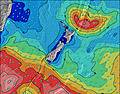 | ||||||||||||||||||||
| Altura de Olas (m) & dirección (?) | ||||||||||||||||||||||||
| Período(s) (?) | 13 | 13 | 13 | 13 | 14 | 14 | 13 | 13 | 13 | 13 | 9 | 11 | 11 | 10 | 10 | 10 | 16 | 8 | 10 | 10 | 9 | 9 | 10 | 10 |
Gráfico (?)Olas | ||||||||||||||||||||||||
| 384 | 384 | 384 | 384 | 395 | 395 | 384 | 372 | 367 | 298 | 328 | 999 | 1100 | 910 | 690 | 565 | 1675 | 989 | 1768 | 1455 | 1194 | 1109 | 1245 | 1153 | |
Viento (km/h) | ||||||||||||||||||||||||
| Estado del Viento (?) onshore Viento de Mar-Cruzado Cruzado Viento de Tierra-Cruzado Viento de Tierra Cristalino | on | glass | glass | cross | glass | cross | cross- on | cross | cross- off | cross- on | cross- on | cross- on | cross- on | cross | cross | cross- on | cross- off | cross- off | cross- off | cross- off | cross- off | cross- off | off | cross- off |
Marea alta / altura (m) | 8:27PM 2.67 | 8:56AM 2.82 | 9:25PM 2.79 | 9:47AM 2.96 | 10:12PM 2.90 | 10:30AM 3.06 | ||||||||||||||||||
Marea baja / altura (m) | 2:12PM 0.76 | 2:42AM 0.79 | 3:12PM 0.61 | 3:36AM 0.62 | 4:00PM 0.47 | 4:21AM 0.47 | ||||||||||||||||||
sábado 28 | domingo 29 | lunes 30 | martes 31 | |||||||||||||||||||||
| Amanecer | - | - | - | - | - | - | 7:45 | - | - | - | - | - | - | - | 7:46 | - | - | - | - | - | - | - | 7:47 | - |
| Puesta del Sol | - | 7:32 | - | - | - | - | - | - | - | 7:30 | - | - | - | - | - | - | - | 7:29 | - | - | - | - | - | - |
Lluvia (mm) | - | - | - | - | - | - | - | 3 | 2 | - | 1 | 4 | 5 | 1 | - | 1 | 1 | - | - | - | - | - | - | - |
| Temp. °C | 19 | 18 | 17 | 16 | 16 | 16 | 18 | 17 | 17 | 18 | 17 | 15 | 15 | 16 | 17 | 18 | 15 | 15 | 14 | 13 | 13 | 13 | 14 | 15 |
| Feels °C (?) | 20 | 19 | 18 | 16 | 16 | 16 | 17 | 18 | 16 | 17 | 16 | 12 | 14 | 16 | 17 | 18 | 10 | 10 | 9 | 7 | 8 | 8 | 9 | 10 |
- Map Icons:
 Break
Break Live Wave Height (m)
 Live Wind Speed (km/h)
 Surf Rating (10 Max)
 Ocean Swells (m)
- Wind Speed (km/h)
GRÁTIS! Un widget de Surf-Forecast.com para tu sitio
Este widget grátis de previsiones de surf y tiempo puede ser añadido a cualquier otro sitio y da un resumen de previsiones de olas para Shingles. Solo necesita cortar y pegar el código HTML de abajo en su web. Puede elegir preferencias de idioma y de unidades (métricas o imperiales) para convenir a los usuarios de su sitio. Clica aquí para obtener el código.
 Nearest