

- Forecast
- Maps
- Live
- Weather State
- Spot Information
711 Surf Forecast
/ New Jersey (82 breaks) / New Jersey (82 breaks) /
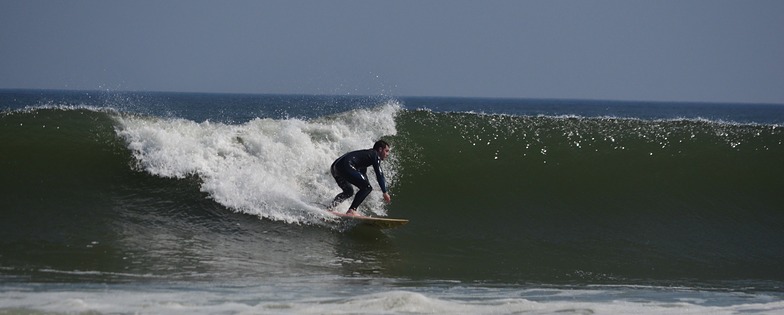
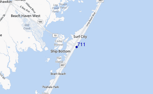
711 surf Forecast / New Jersey / USA
- Map Icons:
 Break
Break Live Wave Height (m)
 Live Wind Speed (km/h)
 Surf Rating (10 Max)
 Ocean Swells (m)
- Wind Speed (km/h)
Best Forecast Surf Conditions for 711 this week:
The surf forecast for 711 over the next 12 days: The first swell (rated 1 star or higher) is forecast to arrive on Saturday (Apr 27) at 2AM. The primary swell is predicted to be 0.7m and 7s period with a secondary swell of 0.1m and 11s. Another secondary swell of 0.1m and 11s is also forecast. The wind is predicted to be cross-shore as the swell arrives.
The most powerful waves expected at 711 in the next 12 days are 0.6m 10s and forecast to arrive on Sunday (Apr 28) at 2PM. Winds are predicted to be cross-offshore at the time the swell arrives. The largest open ocean swell (not directed at the beach) is 1.0m 6s period and expected on Tuesday (Apr 30) at 8PM.
| Wave Type | Time (EDT) & Date | Wave Height & Period |
|---|---|---|
| Next good surf (1 star+) | 2AM (Sat 27th Apr) | 2.5ft (0.7m) 7s |
| Best Surf | 8AM (Sun 28th Apr) | 2ft (0.6m) 8s |
| Most Powerful | 2PM (Sun 28th Apr) | 2ft (0.6m) 10s |
Table - best surf conditions forecast for 711 over the next 12 days.
 Recent Eyeball Surf Reports for New Jersey
Saturday 27 | Sunday 28 | Monday 29 | Tuesday 30 | Wednesday 01 | Thursday 02 | Friday 03 | Saturday 04 | Sunday 05 | Monday 06 | Tuesday 07 | Wed 08 | |||||||||||||||||||||||||
| Night | AM | PM | Night | AM | PM | Night | AM | PM | Night | AM | PM | Night | AM | PM | Night | AM | PM | Night | AM | PM | Night | AM | PM | Night | AM | PM | Night | AM | PM | Night | AM | PM | Night | AM | PM | |
Rating (10 max) | ||||||||||||||||||||||||||||||||||||
Swell Height Map |  |  |  |  |  | 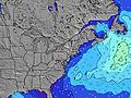 | 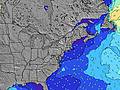 | 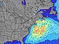 | 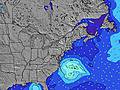 | 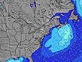 | 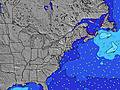 | 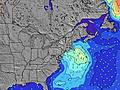 | 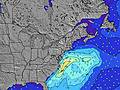 | |||||||||||||||||||||||
| Wave Height (m) & direction (?) | ||||||||||||||||||||||||||||||||||||
| Period(s) (?) | 7 | 7 | 7 | 7 | 8 | 10 | 10 | 9 | 10 | 9 | 10 | 6 | 6 | 5 | 6 | 6 | 6 | 6 | 5 | 9 | 4 | 5 | 5 | 5 | 5 | 6 | 6 | 5 | 5 | 5 | 6 | 6 | 4 | 6 | 6 | 6 |
Wave (?)Graph | ||||||||||||||||||||||||||||||||||||
| Energy (?) | 56 | 35 | 26 | 18 | 55 | 49 | 31 | 29 | 28 | 14 | 17 | 23 | 33 | 71 | 73 | 53 | 39 | 25 | 11 | 7 | 14 | 27 | 41 | 22 | 33 | 34 | 24 | 8 | 5 | 3 | 3 | 4 | 20 | 89 | 126 | 30 |
Wind (km/h) | ||||||||||||||||||||||||||||||||||||
| Wind State (?) onshore cross-onshore cross-shore cross-offshore offshore glassy | cross | cross- on | cross | cross- off | cross- off | cross- off | off | cross- off | cross- on | cross- on | cross- on | cross- on | cross- on | cross- on | on | cross- on | cross- off | cross- off | cross- off | cross- off | cross- off | cross- off | cross- off | cross- off | cross- on | off | cross- off | off | cross- off | cross- off | cross- off | cross | cross- off | cross | cross- off | off |
High Tide / height (m) | 9:39PM 1.48 | 10:14AM 1.16 | 10:21PM 1.45 | 11:04AM 1.13 | 11:14PM 1.42 | 12:01PM 1.12 | 12:15AM 1.40 | 1:02PM 1.14 | 1:19AM 1.39 | 2:04PM 1.19 | 2:22AM 1.40 | 3:06PM 1.27 | 3:26AM 1.42 | 4:08PM 1.38 | 4:29AM 1.45 | 5:07PM 1.51 | 5:29AM 1.48 | 6:01PM 1.64 | 6:24AM 1.50 | 6:51PM 1.73 | 7:16AM 1.50 | 7:39PM 1.78 | 8:07AM 1.47 | |||||||||||||
Low Tide / height (m) | 4:25AM 0.08 | 4:11PM 0.19 | 5:07AM 0.12 | 4:51PM 0.22 | 5:56AM 0.16 | 5:41PM 0.26 | 6:57AM 0.20 | 6:52PM 0.29 | 8:07AM 0.18 | 8:18PM 0.27 | 9:12AM 0.12 | 9:33PM 0.20 | 10:09AM 0.03 | 10:36PM 0.09 | 11:00AM -0.05 | 11:33PM -0.01 | 11:49AM -0.12 | 12:28AM -0.09 | 12:37PM -0.15 | 1:22AM -0.15 | 1:25PM -0.15 | 2:14AM -0.17 | 2:13PM -0.12 | |||||||||||||
Saturday 27 | Sunday 28 | Monday 29 | Tuesday 30 | Wednesday 01 | Thursday 02 | Friday 03 | Saturday 04 | Sunday 05 | Monday 06 | Tuesday 07 | Wed 08 | |||||||||||||||||||||||||
| Sunrise | - | 6:01 | - | - | 6:00 | - | - | 5:58 | - | - | 5:58 | - | - | 5:56 | - | - | 5:54 | - | - | 5:54 | - | - | 5:52 | - | - | 5:52 | - | - | 5:50 | - | - | 5:48 | - | - | 5:48 | - |
| Sunset | - | - | 7:46 | - | - | 7:47 | - | - | 7:49 | - | - | 7:50 | - | - | 7:51 | - | - | 7:52 | - | - | 7:52 | - | - | 7:53 | - | - | 7:54 | - | - | 7:55 | - | - | 7:57 | - | - | 7:58 |
Rain (mm) | - | - | - | 1 | - | - | 1 | - | - | 2 | 1 | - | - | - | - | - | - | - | - | - | - | 1 | - | - | 5 | - | - | - | - | - | - | - | - | 14 | 1 | - |
| Temp. °C | 8 | 9 | 9 | 11 | 14 | 22 | 23 | 24 | 24 | 19 | 13 | 14 | 10 | 9 | 9 | 9 | 14 | 15 | 13 | 16 | 17 | 14 | 19 | 22 | 19 | 16 | 18 | 15 | 15 | 21 | 21 | 17 | 19 | 16 | 20 | 25 |
| Feels °C (?) | 2 | 4 | 3 | 7 | 11 | 19 | 21 | 23 | 24 | 18 | 12 | 12 | 7 | 3 | 4 | 6 | 11 | 10 | 8 | 11 | 11 | 10 | 19 | 21 | 18 | 10 | 11 | 10 | 10 | 17 | 19 | 14 | 16 | 14 | 20 | 22 |
Short Range Forecast: Light rain (total 2mm), mostly falling on Sat night. Warm (max 24°C on Mon morning, min 7°C on Fri night). Wind will be generally light. | Days 3-6 Weather Summary Light rain (total 3mm), mostly falling on Mon night. Very mild (max 19°C on Mon night, min 8°C on Wed morning). Wind will be generally light. | Days 6-9 Weather Summary Light rain (total 6mm), mostly falling on Sat night. Warm (max 22°C on Sat afternoon, min 12°C on Thu night). Mainly fresh winds. | Long Range Forecast: Moderate rain (total 15mm), heaviest on Tue night. Warm (max 25°C on Wed afternoon, min 11°C on Sun night). Wind will be generally light. | |||||||||||||||||||||||||||||||||
FREE! Surf-Forecast.com widget for your website
The surf report / weather widget below is available to embed on third party websites free of charge and provides a summary of our 711 surf forecast. Simply grab the html code snippet that we provide and paste it into your own site. You can choose your preferred language and metric/imperial units for the surf forecast feed to suit users of your site. Click here to get the code.

View detailed surf forecast for 711 at:
surf-forecast.com
Information about the 711 Surf forecast
The above surf forecast table for 711 provides essential information for determining whether the surfing conditions will be good over the next 12 days. A general guide to surfing at 711 can be found by selecting the local surf guide option on the grey menu. Our 711 surf forecast is unique since it includes wave energy (power) that defines the real feel of the surf rather than just the height or the period. If you surf the same spot (711) regularly then make a mental note of the wave energy from the surf forecast table each time you go. Very soon you may start to choose your surf days based on the wave energy alone combined with our forecast of favourable offshore wind conditions. Our star ratings will help here and of course you will also find the usual wave height and period predictions on our surf forecasts as well as a full break down of the swell components under our advanced users option (to reveal that, click the little Einstein character under the tide times).
Further information to help with frequently asked questions about our surf forecast for 711 may be found under the help tab on the top menu and also by moving your mouse over the question marks on the surf forecast table itself. Please always bear in mind that the forecast is for near-shore open water and local factors at each surf break influence the actual breaking wave height, such as the beach / reef profile, water depths offshore and shelter.
Are you planning a vacation in New Jersey? If you are looking for accommodation near 711, camping, hotels and condos and appartments in New Jersey, consider staying in Ocean Acres which is 14 km (9 miles) away. Other places in and around New Jersey where you can find information about places to rent, and car hire include Toms River which is 34 km (21 miles) away, Atlantic City, Pleasantville and Point Pleasant.


 Nearest