
San Jose Island Surf Guide
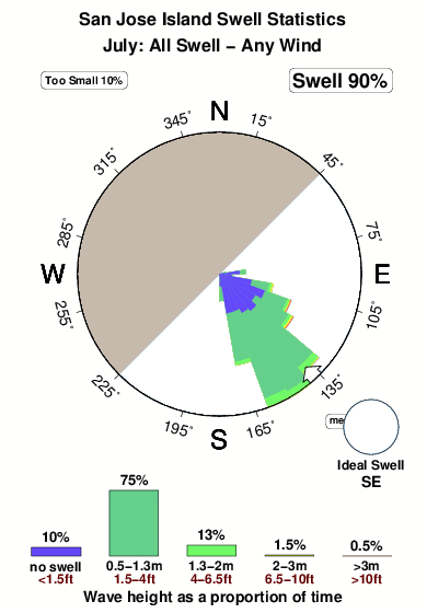
San Jose Island in Texas is an exposed beach/Jetty break that only works once in a while. The optimum conditions for surfing are during the hurricane season. Offshore winds are from the northwest. Waves more likely to be from local windswells than distant groundswells and the ideal wave direction is from the southeast.. Good surf at all stages of the tide. Rarely crowded here. Beware of rips, obstacles, sharks and jellyfish.
San Jose Island Spot Info
| Type: | Rating: | Reliability: | Todays Sea Temp*: |
|---|---|---|---|
| inconsistent | 29.4°C*ocean temperature recorded from satellite |
Surfing San Jose Island:
The best conditions reported for surf at San Jose Island occur when a Southeast swell combines with an offshore wind direction from the Northwest.
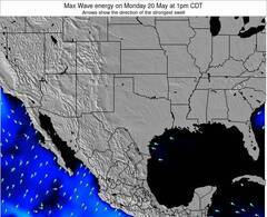
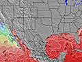
Energía de Olas (poder): 12 horas
San Jose Island Surf:
Thursday, 30 July 2026, 02:30 Local time| mié | jueves 30 | |||
| 10PM | 1AM | 4AM | 7AM | |
| Wave (m) | ||||
| Período (s) | 5 | 5 | 5 | 6 |
| Viento (km/h) | ||||
| Estado del Viento | cross- on |
cross- on |
cross- on |
cross- on |
- /breaks/San-Jose-Island/forecasts/latest
San Jose Island Surf Guide
San Jose Island in Texas is an exposed beach/Jetty break that only works once in a while. The optimum conditions for surfing are during the hurricane season. Offshore winds are from the northwest. Waves more likely to be from local windswells than distant groundswells and the ideal wave direction is from the southeast.. Good surf at all stages of the tide. Rarely crowded here. Beware of rips, obstacles, sharks and jellyfish.
San Jose Island Spot Info
Type: Rating: Reliability: Todays Sea Temp*:  Beach/jetty
 2
2inconsistent 29.4°C*ocean temperature recorded from satelliteSurfing San Jose Island:
The best conditions reported for surf at San Jose Island occur when a Southeast swell combines with an offshore wind direction from the Northwest.
Energía de Olas (poder): 12 horas
Usa la barra de navegación de arriba para ver la temperatura del mar en San Jose Island, fotografías San Jose Island, previsiones detalladas de olas para San Jose Island, vientos y previsión del tiempo, webcams para San Jose Island, viento actual desde estaciones meteorológicas en Texas y predicciones de marea para San Jose Island. Las mapas de olas para United States enseñarán un mapa grande de United States y los mares que rodean. Los mapas de olas pueden ser animadas para mostrar diferentes componentes de olas, la altura de ola, la energía de ola, el período, junto con previsiones de viento y del tiempo. Previsiones actuales del tiempo y del estado del mar provienen de boyas marinas de United States, del barcos que transitan en la zona y de estaciones meteorológicas costeras. Cada página de previsiones tiene un Busca-Olas Regional y Global para localizar las mejores condiciones para surfear en el área de San Jose Island.
San Jose Island Surf:
Thursday, 30 July 2026, 02:30 Local timemié jueves 30 10PM 1AM 4AM 7AM Wave (m) Período (s) 5 5 5 6 Viento (km/h) Estado del Viento cross-
oncross-
oncross-
oncross-
on- /breaks/San-Jose-Island/forecasts/latest
- /breaks/San-Jose-Island/forecasts/latest/six_day
San Jose Island Surf Guide
San Jose Island in Texas is an exposed beach/Jetty break that only works once in a while. The optimum conditions for surfing are during the hurricane season. Offshore winds are from the northwest. Waves more likely to be from local windswells than distant groundswells and the ideal wave direction is from the southeast.. Good surf at all stages of the tide. Rarely crowded here. Beware of rips, obstacles, sharks and jellyfish.
San Jose Island Spot Info
Type: Rating: Reliability: Todays Sea Temp*: Beach/jetty2inconsistent 29.4°C*ocean temperature recorded from satelliteSurfing San Jose Island:
The best conditions reported for surf at San Jose Island occur when a Southeast swell combines with an offshore wind direction from the Northwest.
Energía de Olas (poder): 12 horas
Usa la barra de navegación de arriba para ver la temperatura del mar en San Jose Island, fotografías San Jose Island, previsiones detalladas de olas para San Jose Island, vientos y previsión del tiempo, webcams para San Jose Island, viento actual desde estaciones meteorológicas en Texas y predicciones de marea para San Jose Island. Las mapas de olas para United States enseñarán un mapa grande de United States y los mares que rodean. Los mapas de olas pueden ser animadas para mostrar diferentes componentes de olas, la altura de ola, la energía de ola, el período, junto con previsiones de viento y del tiempo. Previsiones actuales del tiempo y del estado del mar provienen de boyas marinas de United States, del barcos que transitan en la zona y de estaciones meteorológicas costeras. Cada página de previsiones tiene un Busca-Olas Regional y Global para localizar las mejores condiciones para surfear en el área de San Jose Island.
San Jose Island Surf:
Thursday, 30 July 2026, 02:30 Local timemié jueves 30 10PM 1AM 4AM 7AM Wave (m) Período (s) 5 5 5 6 Viento (km/h) Estado del Viento cross-
oncross-
oncross-
oncross-
on- /breaks/San-Jose-Island/forecasts/latest
San Jose Island Surf Guide
San Jose Island in Texas is an exposed beach/Jetty break that only works once in a while. The optimum conditions for surfing are during the hurricane season. Offshore winds are from the northwest. Waves more likely to be from local windswells than distant groundswells and the ideal wave direction is from the southeast.. Good surf at all stages of the tide. Rarely crowded here. Beware of rips, obstacles, sharks and jellyfish.
San Jose Island Spot Info
Type: Rating: Reliability: Todays Sea Temp*: Beach/jetty2inconsistent 29.4°C*ocean temperature recorded from satelliteSurfing San Jose Island:
The best conditions reported for surf at San Jose Island occur when a Southeast swell combines with an offshore wind direction from the Northwest.
Energía de Olas (poder): 12 horas
Usa la barra de navegación de arriba para ver la temperatura del mar en San Jose Island, fotografías San Jose Island, previsiones detalladas de olas para San Jose Island, vientos y previsión del tiempo, webcams para San Jose Island, viento actual desde estaciones meteorológicas en Texas y predicciones de marea para San Jose Island. Las mapas de olas para United States enseñarán un mapa grande de United States y los mares que rodean. Los mapas de olas pueden ser animadas para mostrar diferentes componentes de olas, la altura de ola, la energía de ola, el período, junto con previsiones de viento y del tiempo. Previsiones actuales del tiempo y del estado del mar provienen de boyas marinas de United States, del barcos que transitan en la zona y de estaciones meteorológicas costeras. Cada página de previsiones tiene un Busca-Olas Regional y Global para localizar las mejores condiciones para surfear en el área de San Jose Island.
San Jose Island Surf:
Thursday, 30 July 2026, 02:30 Local timemié jueves 30 10PM 1AM 4AM 7AM Wave (m) Período (s) 5 5 5 6 Viento (km/h) Estado del Viento cross-
oncross-
oncross-
oncross-
onTide Times:
En San Jose Island (0 km).
PROXIMA ES A LAS (hora local) quedan marea alta marea baja San Jose Island Tide Times and Tide Chart
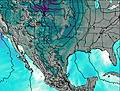
Live Weather:
At BUOY-ANPT2, 11 km from San Jose Island.
fresh winds from the SE
(km/h)Air temperature
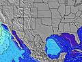
-°COverall San Jose Island Surf Consistency and Wind Distribution in julio
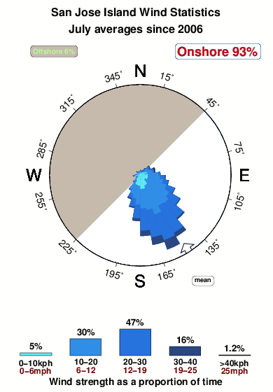


Wind stats for San Jose Island: see the variation in direction and stength by month.
Fotos de Surf
de la galeríaContornos: Carreteras y Ríos: Selecciona un spot desde el menú 


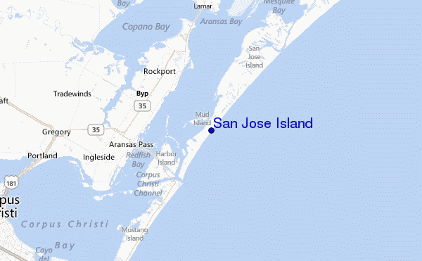
Usa este mapa para navegar hacia las playas de surf de Texas y estaciones de marea cercanas de San Jose Island
Spots de Surf más cercanos a San Jose Island:
(Clica la ubicación para más detalles)- Closest spot7 mi
- Second closest spot7 mi
- Third closest spot7 mi
- Fourth closest spot10 mi
- Fifth closest spot11 mi
Boyas marinas más cercanas a San Jose Island:
- Closest Boya Marinas68 mi
- Second closest Boya Marinas99 mi
- Third closest Boya Marinas181 mi
- Fourth closest Boya Marinas252 mi
- Fifth closest Boya Marinas396 mi
Estaciones de marea más cercanas a San Jose Island:
- Closest estación de mareaAransas Channel7 mi
- Second closest estación de mareaPort Aransas, Holiday Beach7 mi
- Third closest estación de mareaRockport, Aransas Bay7 mi
- Fourth closest estación de mareaPort Aransas8 mi
- Fifth closest estación de mareaAransas Pass10 mi
Airports
- The closest passenger airport to San Jose Island is Corpus Christi International Airport (CRP) in USA, 53 km (33 miles) away (directly).
- The second nearest airport to San Jose Island is Kingsville Nas Airport (NQI), also in USA, 93 km (58 miles) away.
- Third is Alice International Airport (ALI) in USA, 104 km (65 miles) away.
- Palacios Muni Airport (PSX) in USA is 115 km (71 miles) away.
- Pleasanton Muni (Penza) Airport (PEZ) in Russia is the fifth nearest airport to San Jose Island and is 188 km (117 miles) away.

- /breaks/San-Jose-Island/forecasts/latest


 Nearest