Previsiones:

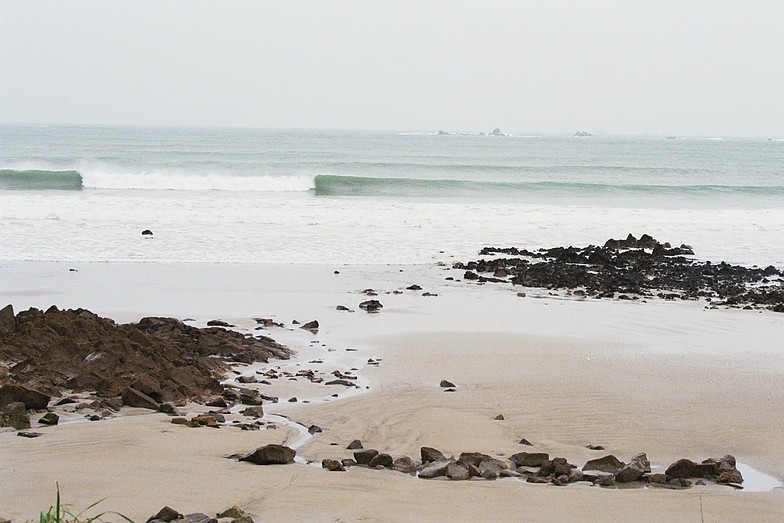
Surf en St Jean de DoigtPronóstico / Brittany – Finistere / France
Actualizacion del pronostico en hora min s Forecast update imminent
La altura de oleaje para St Jean de Doigt es en mar abierto. Olas rompiendo en la orilla/arrecife son usualmente más pequeñas en áreas protegidas.
La temperatura del mar en St Jean de Doigt hoy es
12.5° C
(Lo cual es ligeramente más cálido de lo habitual)Nearby Cam: 10km away, Webcam Locquirec
Actualizaciones en hora min s Forecast update imminent
sábado 20 | domingo 21 | lunes 22 | martes 23 | |||||||||||||||||||||
| 4 PM | 7 PM | 10 PM | 1 AM | 4 AM | 7 AM | 10 AM | 1 PM | 4 PM | 7 PM | 10 PM | 1 AM | 4 AM | 7 AM | 10 AM | 1 PM | 4 PM | 7 PM | 10 PM | 1 AM | 4 AM | 7 AM | 10 AM | 1 PM | |
Notación (10 max) | ||||||||||||||||||||||||
Mapa de Altura de Olas |    |    |    |    | ||||||||||||||||||||
| Altura de Olas (m) & dirección (?) | ||||||||||||||||||||||||
| Período(s) (?) | 13 | 13 | 12 | 12 | 12 | 16 | 15 | 16 | 15 | 16 | 16 | 15 | 15 | 14 | 14 | 14 | 13 | 13 | 13 | 12 | 12 | 12 | 12 | 11 |
Gráfico (?)Olas | ||||||||||||||||||||||||
| 1306 | 1317 | 1454 | 1599 | 1626 | 4213 | 4374 | 4676 | 4436 | 4494 | 4004 | 3371 | 2655 | 2082 | 1759 | 1495 | 1127 | 1014 | 822 | 680 | 536 | 527 | 414 | 379 | |
Viento (km/h) | ||||||||||||||||||||||||
| Estado del Viento (?) onshore Viento de Mar-Cruzado Cruzado Viento de Tierra-Cruzado Viento de Tierra Cristalino | cross- off | cross- off | cross- off | cross- off | off | off | off | cross- off | cross- off | cross- off | cross- off | cross- off | off | cross- off | off | cross- off | off | off | off | glass | cross- off | cross | cross | cross |
Marea alta / altura (m) | 6:28PM 6.79 | 6:43AM 7.04 | 7:03PM 6.84 | 7:17AM 7.10 | 7:38PM 6.83 | 7:52AM 7.09 | ||||||||||||||||||
Marea baja / altura (m) | 12:48AM 1.14 | 1:09PM 0.95 | 1:23AM 1.06 | 1:45PM 0.89 | 1:58AM 1.05 | |||||||||||||||||||
sábado 20 | domingo 21 | lunes 22 | martes 23 | |||||||||||||||||||||
| Amanecer | - | - | - | - | - | - | 9:03 | - | - | - | - | - | - | - | 9:04 | - | - | - | - | - | - | - | 9:04 | - |
| Puesta del Sol | 5:20 | - | - | - | - | - | - | - | 5:21 | - | - | - | - | - | - | - | 5:21 | - | - | - | - | - | - | - |
Lluvia (mm) | - | 2 | 1 | - | - | - | 1 | - | 1 | 1 | 2 | 1 | - | - | - | - | - | - | - | - | - | - | - | - |
| Temp. °C | 11 | 10 | 9 | 9 | 8 | 8 | 8 | 9 | 10 | 10 | 10 | 10 | 9 | 8 | 10 | 10 | 10 | 9 | 8 | 8 | 8 | 10 | 11 | 10 |
| Feels °C (?) | 5 | 4 | 5 | 5 | 3 | 3 | 4 | 3 | 5 | 5 | 8 | 8 | 6 | 5 | 6 | 6 | 7 | 6 | 5 | 6 | 5 | 7 | 7 | 3 |
- Map Icons:
 Break
Break Live Wave Height (m)
 Live Wind Speed (km/h)
 Surf Rating (10 Max)
 Ocean Swells (m)
- Wind Speed (km/h)
GRÁTIS! Un widget de Surf-Forecast.com para tu sitio
Este widget grátis de previsiones de surf y tiempo puede ser añadido a cualquier otro sitio y da un resumen de previsiones de olas para St Jean de Doigt. Solo necesita cortar y pegar el código HTML de abajo en su web. Puede elegir preferencias de idioma y de unidades (métricas o imperiales) para convenir a los usuarios de su sitio. Clica aquí para obtener el código.
 Nearest