

Robert Moses State Park Surf Guide
Robert Moses State Park in Long Island NY is an exposed beach break that has quite reliable surf and can work at any time of the year. Offshore winds are from the northwest with some shelter here from west winds. Tends to receive a mix of groundswells and windswells and the ideal swell direction is from the southeast. The beach break offers both left and right hand waves. Good surf at all stages of the tide. When the surf is up, it can get quite busy in the water. Take care of the strong rips here.
Robert Moses State Park Spot Info
| Type: | Rating: | Reliability: | Todays Sea Temp*: |
|---|---|---|---|
| fairly consistent | 23.3°C*ocean temperature recorded from satellite |
Surfing Robert Moses State Park:
The best conditions reported for surf at Robert Moses State Park occur when a South-southeast swell combines with an offshore wind direction from the North-northwest.

Energía de Olas (poder): 12 horas


Robert Moses State Park Surf:
Wednesday, 29 July 2026, 15:41 Local time| miércoles 29 | ||||
| 11AM | 2PM | 5PM | 8PM | |
| Wave (m) | ||||
| Período (s) | 6 | 6 | 6 | 7 |
| Viento (km/h) | ||||
| Estado del Viento | cross- off |
glass | glass | off |
- /breaks/Robert-Moses-State-Park/forecasts/latest
Robert Moses State Park Surf Guide
Robert Moses State Park in Long Island NY is an exposed beach break that has quite reliable surf and can work at any time of the year. Offshore winds are from the northwest with some shelter here from west winds. Tends to receive a mix of groundswells and windswells and the ideal swell direction is from the southeast. The beach break offers both left and right hand waves. Good surf at all stages of the tide. When the surf is up, it can get quite busy in the water. Take care of the strong rips here.
Robert Moses State Park Spot Info
Type: Rating: Reliability: Todays Sea Temp*:  Beach
Beach 2
2fairly consistent 23.3°C*ocean temperature recorded from satelliteSurfing Robert Moses State Park:
The best conditions reported for surf at Robert Moses State Park occur when a South-southeast swell combines with an offshore wind direction from the North-northwest.
Energía de Olas (poder): 12 horas
Usa la barra de navegación de arriba para ver la temperatura del mar en Robert Moses State Park, fotografías Robert Moses State Park, previsiones detalladas de olas para Robert Moses State Park, vientos y previsión del tiempo, webcams para Robert Moses State Park, viento actual desde estaciones meteorológicas en Long Island NY y predicciones de marea para Robert Moses State Park. Las mapas de olas para United States enseñarán un mapa grande de United States y los mares que rodean. Los mapas de olas pueden ser animadas para mostrar diferentes componentes de olas, la altura de ola, la energía de ola, el período, junto con previsiones de viento y del tiempo. Previsiones actuales del tiempo y del estado del mar provienen de boyas marinas de United States, del barcos que transitan en la zona y de estaciones meteorológicas costeras. Cada página de previsiones tiene un Busca-Olas Regional y Global para localizar las mejores condiciones para surfear en el área de Robert Moses State Park.
Robert Moses State Park Surf:
Wednesday, 29 July 2026, 15:41 Local timemiércoles 29 11AM 2PM 5PM 8PM Wave (m) Período (s) 6 6 6 7 Viento (km/h) Estado del Viento cross-
offglass glass off - /breaks/Robert-Moses-State-Park/forecasts/latest
- /breaks/Robert-Moses-State-Park/forecasts/latest/six_day
Robert Moses State Park Surf Guide
Robert Moses State Park in Long Island NY is an exposed beach break that has quite reliable surf and can work at any time of the year. Offshore winds are from the northwest with some shelter here from west winds. Tends to receive a mix of groundswells and windswells and the ideal swell direction is from the southeast. The beach break offers both left and right hand waves. Good surf at all stages of the tide. When the surf is up, it can get quite busy in the water. Take care of the strong rips here.
Robert Moses State Park Spot Info
Type: Rating: Reliability: Todays Sea Temp*: Beach2fairly consistent 23.3°C*ocean temperature recorded from satelliteSurfing Robert Moses State Park:
The best conditions reported for surf at Robert Moses State Park occur when a South-southeast swell combines with an offshore wind direction from the North-northwest.
Energía de Olas (poder): 12 horas
Usa la barra de navegación de arriba para ver la temperatura del mar en Robert Moses State Park, fotografías Robert Moses State Park, previsiones detalladas de olas para Robert Moses State Park, vientos y previsión del tiempo, webcams para Robert Moses State Park, viento actual desde estaciones meteorológicas en Long Island NY y predicciones de marea para Robert Moses State Park. Las mapas de olas para United States enseñarán un mapa grande de United States y los mares que rodean. Los mapas de olas pueden ser animadas para mostrar diferentes componentes de olas, la altura de ola, la energía de ola, el período, junto con previsiones de viento y del tiempo. Previsiones actuales del tiempo y del estado del mar provienen de boyas marinas de United States, del barcos que transitan en la zona y de estaciones meteorológicas costeras. Cada página de previsiones tiene un Busca-Olas Regional y Global para localizar las mejores condiciones para surfear en el área de Robert Moses State Park.
Robert Moses State Park Surf:
Wednesday, 29 July 2026, 15:41 Local timemiércoles 29 11AM 2PM 5PM 8PM Wave (m) Período (s) 6 6 6 7 Viento (km/h) Estado del Viento cross-
offglass glass off - /breaks/Robert-Moses-State-Park/forecasts/latest
Robert Moses State Park Surf Guide
Robert Moses State Park in Long Island NY is an exposed beach break that has quite reliable surf and can work at any time of the year. Offshore winds are from the northwest with some shelter here from west winds. Tends to receive a mix of groundswells and windswells and the ideal swell direction is from the southeast. The beach break offers both left and right hand waves. Good surf at all stages of the tide. When the surf is up, it can get quite busy in the water. Take care of the strong rips here.
Robert Moses State Park Spot Info
Type: Rating: Reliability: Todays Sea Temp*: Beach2fairly consistent 23.3°C*ocean temperature recorded from satelliteSurfing Robert Moses State Park:
The best conditions reported for surf at Robert Moses State Park occur when a South-southeast swell combines with an offshore wind direction from the North-northwest.
Energía de Olas (poder): 12 horas
Usa la barra de navegación de arriba para ver la temperatura del mar en Robert Moses State Park, fotografías Robert Moses State Park, previsiones detalladas de olas para Robert Moses State Park, vientos y previsión del tiempo, webcams para Robert Moses State Park, viento actual desde estaciones meteorológicas en Long Island NY y predicciones de marea para Robert Moses State Park. Las mapas de olas para United States enseñarán un mapa grande de United States y los mares que rodean. Los mapas de olas pueden ser animadas para mostrar diferentes componentes de olas, la altura de ola, la energía de ola, el período, junto con previsiones de viento y del tiempo. Previsiones actuales del tiempo y del estado del mar provienen de boyas marinas de United States, del barcos que transitan en la zona y de estaciones meteorológicas costeras. Cada página de previsiones tiene un Busca-Olas Regional y Global para localizar las mejores condiciones para surfear en el área de Robert Moses State Park.
Robert Moses State Park Surf:
Wednesday, 29 July 2026, 15:41 Local timemiércoles 29 11AM 2PM 5PM 8PM Wave (m) Período (s) 6 6 6 7 Viento (km/h) Estado del Viento cross-
offglass glass off Tide Times:
Para Fire Island Breakwater, Long Island, New York, a %{dist} %{km} de %{location}.
PROXIMA ES A LAS (hora local) quedan marea alta marea baja Robert Moses State Park Tide Times and Tide Chart
Live Weather:
At BUOY-44069, 17 km from Robert Moses State Park.
light winds from the SSE
(km/h)Air temperature
22.9°CCurrent weather near Robert Moses State Park
Buoy Data:
At Long Island Buoy, 26 miles from Robert Moses State Park.
10AM 11AM 12PM 1PM Antigüedad de datos 4 hr 3 hr 2 hr 1 hr Altura de Olas (m) 


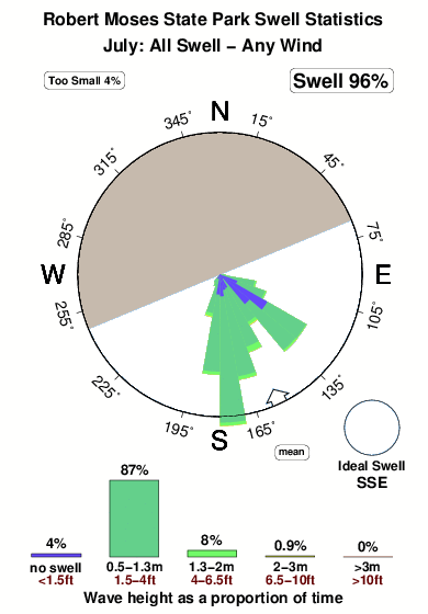
Período Dominante (s) 6 6 - 6 Overall Robert Moses State Park Surf Consistency and Wind Distribution in julio
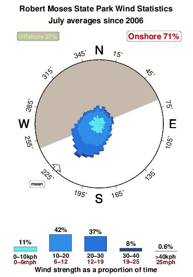


Wind stats for Robert Moses State Park: see the variation in direction and stength by month.
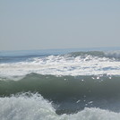
Fotos de Surf
de la galeríaContornos: Carreteras y Ríos: Selecciona un spot desde el menú 
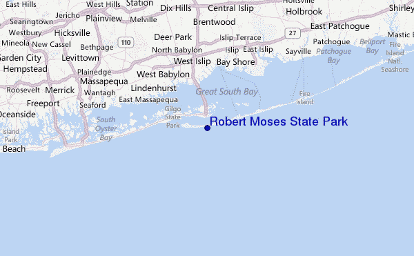
Usa este mapa para navegar hacia las playas de surf de Long Island NY y estaciones de marea cercanas de Robert Moses State Park
Spots de Surf más cercanos a Robert Moses State Park:
(Clica la ubicación para más detalles)- Closest spot2 mi
- Second closest spot4 mi
- Third closest spot7 mi
- Fourth closest spot7 mi
- Fifth closest spot9 mi
Boyas marinas más cercanas a Robert Moses State Park:
- Closest Boya Marinas26 mi
- Second closest Boya Marinas29 mi
- Third closest Boya Marinas29 mi
- Fourth closest Boya Marinas48 mi
- Fifth closest Boya Marinas63 mi
Estaciones de marea más cercanas a Robert Moses State Park:
- Closest estación de mareaFire Island Coast Guard Station, Long Island1 mi
- Second closest estación de mareaOakbeach, Long Island1 mi
- Third closest estación de mareaFire Island Breakwater, Long Island2 mi
- Fourth closest estación de mareaOak Beach, Great South Bay2 mi
- Fifth closest estación de mareaDemocrat Point, Fire Island Inlet, Long Island2 mi
Airports
- The closest passenger airport to Robert Moses State Park is Long Island Mac Arthur (Islip) Airport (ISP) in USA, 24 km (15 miles) away (directly).
- The second nearest airport to Robert Moses State Park is John F Kennedy International (New York) Airport (JFK), also in USA, 44 km (27 miles) away.
- Third is La Guardia (New York) Airport (LGA) in USA, 54 km (34 miles) away.
- The Francis S Gabreski (West Hampton Beach) Airport (FOK) in USA is 58 km (36 miles) away.
- Igor I Sikorsky Mem (Stratford) Airport (BDR), also in USA is the fifth nearest airport to Robert Moses State Park and is 61 km (38 miles) away.

- /breaks/Robert-Moses-State-Park/forecasts/latest


 Nearest