- Forecast
- Maps
- Live
- Weather State
- Spot Information
Pringle Bay Previsión de Olas
/ Overberg (23 surf breaks) /Previsiones:


Surf en Pringle BayPronóstico / Overberg / South Africa
Actualizacion del pronostico en hora min s Forecast update imminent
La altura de oleaje para Pringle Bay es en mar abierto. Olas rompiendo en la orilla/arrecife son usualmente más pequeñas en áreas protegidas.
La temperatura del mar en Pringle Bay hoy es
18.4° C
(Lo cual es 1.1°C más frío que el promedio para esta época del año)Actualizaciones en hora min s Forecast update imminent
viernes 13 | sábado 14 | domingo 15 | lunes 16 | |||||||||||||||||||||
| 11 AM | 2 PM | 5 PM | 8 PM | 11 PM | 2 AM | 5 AM | 8 AM | 11 AM | 2 PM | 5 PM | 8 PM | 11 PM | 2 AM | 5 AM | 8 AM | 11 AM | 2 PM | 5 PM | 8 PM | 11 PM | 2 AM | 5 AM | 8 AM | |
Notación (10 max) | ||||||||||||||||||||||||
Mapa de Altura de Olas |    |    |    |  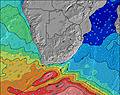 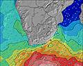 | ||||||||||||||||||||
| Altura de Olas (m) & dirección (?) | ||||||||||||||||||||||||
| Período(s) (?) | 18 | 17 | 16 | 16 | 16 | 15 | 14 | 14 | 13 | 13 | 13 | 12 | 12 | 12 | 11 | 7 | 11 | 11 | 14 | 13 | 13 | 13 | 12 | 12 |
Gráfico (?)Olas | ||||||||||||||||||||||||
| 480 | 1146 | 1067 | 2007 | 2049 | 1693 | 1647 | 1415 | 1018 | 824 | 722 | 543 | 384 | 294 | 227 | 286 | 233 | 191 | 177 | 201 | 491 | 560 | 598 | 703 | |
Viento (km/h) | ||||||||||||||||||||||||
| Estado del Viento (?) onshore Viento de Mar-Cruzado Cruzado Viento de Tierra-Cruzado Viento de Tierra Cristalino | cross- off | cross- off | cross- off | off | off | off | off | off | off | off | off | off | cross- off | cross- off | cross- off | cross- off | off | off | off | off | off | off | off | off |
Marea alta / altura (m) | 11:52AM 1.00 | 12:46AM 1.07 | 12:50PM 1.12 | 1:21AM 1.22 | 1:28PM 1.25 | 1:51AM 1.37 | ||||||||||||||||||
Marea baja / altura (m) | 6:31PM 0.57 | 6:57AM 0.58 | 7:11PM 0.44 | 7:33AM 0.44 | 7:42PM 0.31 | |||||||||||||||||||
viernes 13 | sábado 14 | domingo 15 | lunes 16 | |||||||||||||||||||||
| Amanecer | - | - | - | - | - | - | - | 6:41 | - | - | - | - | - | - | - | 6:43 | - | - | - | - | - | - | - | 6:43 |
| Puesta del Sol | - | - | 7:06 | - | - | - | - | - | - | - | 7:04 | - | - | - | - | - | - | - | 7:02 | - | - | - | - | - |
Lluvia (mm) | - | - | - | - | - | - | - | - | - | - | - | - | - | - | - | - | - | - | - | - | - | - | - | - |
| Temp. °C | 24 | 23 | 22 | 21 | 21 | 20 | 19 | 19 | 21 | 22 | 23 | 22 | 21 | 20 | 19 | 20 | 24 | 23 | 22 | 20 | 21 | 20 | 21 | 21 |
| Feels °C (?) | 23 | 22 | 21 | 20 | 19 | 17 | 16 | 15 | 17 | 17 | 17 | 17 | 17 | 17 | 18 | 19 | 24 | 22 | 19 | 18 | 20 | 19 | 21 | 20 |
- Map Icons:
 Break
Break Live Wave Height (m)
 Live Wind Speed (km/h)
 Surf Rating (10 Max)
 Ocean Swells (m)
- Wind Speed (km/h)
GRÁTIS! Un widget de Surf-Forecast.com para tu sitio
Este widget grátis de previsiones de surf y tiempo puede ser añadido a cualquier otro sitio y da un resumen de previsiones de olas para Pringle Bay. Solo necesita cortar y pegar el código HTML de abajo en su web. Puede elegir preferencias de idioma y de unidades (métricas o imperiales) para convenir a los usuarios de su sitio. Clica aquí para obtener el código.
 Nearest