- Forecast
- Maps
- Live
- Weather State
- Spot Information
Point Grenville Previsión de Olas
/ Washington (29 breaks) / Washington (29 breaks) /Previsiones:

Surf en Point GrenvillePronóstico / Washington / USA
Actualizacion del pronostico en hora min s Forecast update imminent
La altura de oleaje para Point Grenville es en mar abierto. Olas rompiendo en la orilla/arrecife son usualmente más pequeñas en áreas protegidas.
La temperatura del mar en Point Grenville hoy es
9.2° C
(Lo cual es normal para esta época del año)Actualizaciones en hora min s Forecast update imminent
viernes 06 | sábado 07 | domingo 08 | lunes 09 | |||||||||||||||||||||
| 1 PM | 4 PM | 7 PM | 10 PM | 1 AM | 4 AM | 7 AM | 10 AM | 1 PM | 4 PM | 7 PM | 10 PM | 1 AM | 4 AM | 7 AM | 10 AM | 1 PM | 4 PM | 7 PM | 10 PM | 1 AM | 4 AM | 7 AM | 10 AM | |
Notación (10 max) | ||||||||||||||||||||||||
Mapa de Altura de Olas |  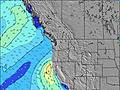 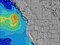 | 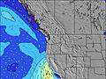 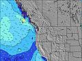 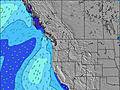 | 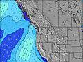 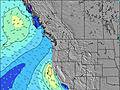 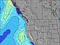 | 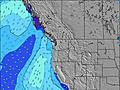 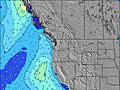 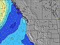 | ||||||||||||||||||||
| Altura de Olas (m) & dirección (?) | ||||||||||||||||||||||||
| Período(s) (?) | 10 | 10 | 10 | 10 | 10 | 10 | 10 | 10 | 11 | 11 | 13 | 13 | 13 | 13 | 13 | 13 | 12 | 13 | 12 | 12 | 12 | 12 | 12 | 12 |
Gráfico (?)Olas | ||||||||||||||||||||||||
| 682 | 652 | 666 | 771 | 771 | 786 | 724 | 840 | 999 | 924 | 1909 | 2069 | 2117 | 2261 | 2252 | 2088 | 1564 | 2366 | 2065 | 1450 | 1271 | 1528 | 923 | 1582 | |
Viento (km/h) | ||||||||||||||||||||||||
| Estado del Viento (?) onshore Viento de Mar-Cruzado Cruzado Viento de Tierra-Cruzado Viento de Tierra Cristalino | cross | cross- on | cross- on | cross- on | cross- on | cross- on | on | on | on | cross- on | cross- on | cross- on | cross- on | cross- on | cross- on | cross- on | cross- on | cross- on | cross- on | cross- on | on | on | cross- on | cross- on |
Marea alta / altura (m) | 2:16PM 2.31 | 2:20AM 2.62 | 2:58PM 2.13 | 2:50AM 2.55 | 3:44PM 1.96 | 3:23AM 2.45 | ||||||||||||||||||
Marea baja / altura (m) | 7:58PM 0.48 | 8:39AM 0.22 | 8:29PM 0.69 | 9:21AM 0.28 | 9:01PM 0.90 | |||||||||||||||||||
viernes 06 | sábado 07 | domingo 08 | lunes 09 | |||||||||||||||||||||
| Amanecer | - | - | - | - | - | - | 6:46 | - | - | - | - | - | - | - | 6:43 | - | - | - | - | - | - | - | 6:41 | - |
| Puesta del Sol | - | 6:08 | - | - | - | - | - | - | - | 6:09 | - | - | - | - | - | - | - | 6:12 | - | - | - | - | - | - |
Lluvia (mm) | 3 | 4 | 2 | 1 | 1 | - | - | 1 | - | - | - | 1 | 2 | 4 | 1 | - | - | - | - | - | - | 1 | 2 | 1 |
| Temp. °C | 10 | 9 | 9 | 9 | 9 | 9 | 9 | 9 | 9 | 9 | 9 | 9 | 9 | 9 | 8 | 8 | 7 | 7 | 7 | 6 | 6 | 6 | 5 | 6 |
| Feels °C (?) | 7 | 7 | 7 | 7 | 7 | 7 | 7 | 7 | 7 | 6 | 7 | 6 | 5 | 5 | 3 | 2 | 1 | 0 | 1 | 0 | 0 | 0 | -2 | -2 |
- Map Icons:
 Break
Break Live Wave Height (m)
 Live Wind Speed (km/h)
 Surf Rating (10 Max)
 Ocean Swells (m)
- Wind Speed (km/h)
GRÁTIS! Un widget de Surf-Forecast.com para tu sitio
Este widget grátis de previsiones de surf y tiempo puede ser añadido a cualquier otro sitio y da un resumen de previsiones de olas para Point Grenville. Solo necesita cortar y pegar el código HTML de abajo en su web. Puede elegir preferencias de idioma y de unidades (métricas o imperiales) para convenir a los usuarios de su sitio. Clica aquí para obtener el código.
 Nearest