- Forecast
- Maps
- Live
- Weather State
- Spot Information
Papara Beach Previsión de Olas
/ Tahiti (22 surf breaks) /Previsiones:

Surf en Papara BeachPronóstico / Tahiti / French Polynesia
Actualizacion del pronostico en hora min s Forecast update imminent
La altura de oleaje para Papara Beach es en mar abierto. Olas rompiendo en la orilla/arrecife son usualmente más pequeñas en áreas protegidas.
La temperatura del mar en Papara Beach hoy es
27.4° C
(Lo cual es normal para esta época del año)Actualizaciones en hora min s Forecast update imminent
sábado 22 | domingo 23 | lunes 24 | mar 25 | |||||||||||||||||||||
| 5 AM | 8 AM | 11 AM | 2 PM | 5 PM | 8 PM | 11 PM | 2 AM | 5 AM | 8 AM | 11 AM | 2 PM | 5 PM | 8 PM | 11 PM | 2 AM | 5 AM | 8 AM | 11 AM | 2 PM | 5 PM | 8 PM | 11 PM | 2 AM | |
Notación (10 max) | ||||||||||||||||||||||||
Mapa de Altura de Olas |  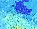  |    |    | 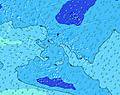 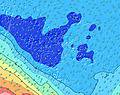 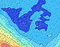 | ||||||||||||||||||||
| Altura de Olas (m) & dirección (?) | ||||||||||||||||||||||||
| Período(s) (?) | 8 | 8 | 8 | 8 | 8 | 8 | 8 | 10 | 10 | 10 | 8 | 8 | 8 | 8 | 8 | 8 | 8 | 8 | 8 | 8 | 8 | 8 | 8 | 8 |
Gráfico (?)Olas | ||||||||||||||||||||||||
| 573 | 564 | 519 | 383 | 571 | 540 | 467 | 413 | 1102 | 504 | 505 | 294 | 237 | 192 | 192 | 188 | 188 | 188 | 213 | 192 | 162 | 162 | 158 | 131 | |
Viento (km/h) | ||||||||||||||||||||||||
| Estado del Viento (?) onshore Viento de Mar-Cruzado Cruzado Viento de Tierra-Cruzado Viento de Tierra Cristalino | cross- off | off | off | cross- off | cross- off | cross- off | cross- off | off | off | off | off | cross- off | cross- off | cross- off | cross- off | cross- off | cross- off | cross- off | off | cross- off | glass | cross- on | cross- off | cross- off |
Marea alta / altura (m) | 1:09PM 0.29 | 1:02AM 0.30 | 1:35PM 0.27 | 1:30AM 0.29 | 2:03PM 0.25 | |||||||||||||||||||
Marea baja / altura (m) | 7:01AM 0.03 | 7:03PM 0.08 | 7:30AM 0.05 | 7:30PM 0.09 | 8:03AM 0.07 | 8:01PM 0.11 | ||||||||||||||||||
sábado 22 | domingo 23 | lunes 24 | mar 25 | |||||||||||||||||||||
| Amanecer | - | 5:13 | - | - | - | - | - | - | - | 5:13 | - | - | - | - | - | - | - | 5:13 | - | - | - | - | - | - |
| Puesta del Sol | - | - | - | - | 6:14 | - | - | - | - | - | - | - | 6:15 | - | - | - | - | - | - | - | 6:15 | - | - | - |
Lluvia (mm) | 24 | 17 | 5 | 4 | 4 | 3 | 3 | 1 | 1 | 1 | 2 | 1 | 3 | 4 | 1 | - | - | - | - | 1 | - | - | - | - |
| Temp. °C | 24 | 25 | 26 | 25 | 26 | 25 | 26 | 26 | 26 | 26 | 26 | 26 | 26 | 25 | 25 | 25 | 26 | 26 | 27 | 27 | 27 | 26 | 27 | 26 |
| Feels °C (?) | 24 | 24 | 24 | 24 | 25 | 25 | 25 | 25 | 23 | 21 | 20 | 22 | 22 | 22 | 23 | 24 | 26 | 28 | 29 | 29 | 29 | 28 | 29 | 27 |
- Map Icons:
 Break
Break Live Wave Height (m)
 Live Wind Speed (km/h)
 Surf Rating (10 Max)
 Ocean Swells (m)
- Wind Speed (km/h)
GRÁTIS! Un widget de Surf-Forecast.com para tu sitio
Este widget grátis de previsiones de surf y tiempo puede ser añadido a cualquier otro sitio y da un resumen de previsiones de olas para Papara Beach. Solo necesita cortar y pegar el código HTML de abajo en su web. Puede elegir preferencias de idioma y de unidades (métricas o imperiales) para convenir a los usuarios de su sitio. Clica aquí para obtener el código.
 Nearest