

Oswald State Park/Short Sands Surf Guide
Oswald State Park/Short Sands in Oregon_North is an exposed beach break that has reasonably consistent surf and can work at any time of the year. The best wind direction is from the east with some shelter here from north winds. Most of the surf here comes from groundswells and the best swell direction is from the southwest. The beach break offers both left and right hand waves. A fairly popluar wave that can sometimes get crowded Watch out for dangerous rips.
Oswald State Park/Short Sands Spot Info
| Type: | Rating: | Reliability: | Todays Sea Temp*: |
|---|---|---|---|
| fairly consistent | 14.3°C*ocean temperature recorded from satellite |
Surfing Oswald State Park/Short Sands:
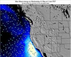
The best conditions reported for surf at Oswald State Park/Short Sands occur when a Southwest swell combines with an offshore wind direction from the East.
Energía de Olas (poder): 12 horas

Oswald State Park/Short Sands Surf:
Thursday, 30 July 2026, 07:02 Local time| jueves 30 | ||||
| 8AM | 11AM | 2PM | 5PM | |
| Wave (m) | ||||
| Período (s) | 16 | 16 | 16 | 16 |
| Viento (km/h) | ||||
| Estado del Viento | off | on | cross- on |
cross- on |
- /breaks/Oswald-West-State-Park/forecasts/latest
Oswald State Park/Short Sands Surf Guide
Oswald State Park/Short Sands in Oregon_North is an exposed beach break that has reasonably consistent surf and can work at any time of the year. The best wind direction is from the east with some shelter here from north winds. Most of the surf here comes from groundswells and the best swell direction is from the southwest. The beach break offers both left and right hand waves. A fairly popluar wave that can sometimes get crowded Watch out for dangerous rips.
Oswald State Park/Short Sands Spot Info
Type: Rating: Reliability: Todays Sea Temp*:  Beach
Beach 1
1fairly consistent 14.3°C*ocean temperature recorded from satelliteSurfing Oswald State Park/Short Sands:
The best conditions reported for surf at Oswald State Park/Short Sands occur when a Southwest swell combines with an offshore wind direction from the East.
Energía de Olas (poder): 12 horas
Usa la barra de navegación de arriba para ver la temperatura del mar en Oswald State Park/Short Sands, fotografías Oswald State Park/Short Sands, previsiones detalladas de olas para Oswald State Park/Short Sands, vientos y previsión del tiempo, webcams para Oswald State Park/Short Sands, viento actual desde estaciones meteorológicas en Oregon North y predicciones de marea para Oswald State Park/Short Sands. Las mapas de olas para United States enseñarán un mapa grande de United States y los mares que rodean. Los mapas de olas pueden ser animadas para mostrar diferentes componentes de olas, la altura de ola, la energía de ola, el período, junto con previsiones de viento y del tiempo. Previsiones actuales del tiempo y del estado del mar provienen de boyas marinas de United States, del barcos que transitan en la zona y de estaciones meteorológicas costeras. Cada página de previsiones tiene un Busca-Olas Regional y Global para localizar las mejores condiciones para surfear en el área de Oswald State Park/Short Sands.
Oswald State Park/Short Sands Surf:
Thursday, 30 July 2026, 07:02 Local timejueves 30 8AM 11AM 2PM 5PM Wave (m) Período (s) 16 16 16 16 Viento (km/h) Estado del Viento off on cross-
oncross-
on- /breaks/Oswald-West-State-Park/forecasts/latest
- /breaks/Oswald-West-State-Park/forecasts/latest/six_day
Oswald State Park/Short Sands Surf Guide
Oswald State Park/Short Sands in Oregon_North is an exposed beach break that has reasonably consistent surf and can work at any time of the year. The best wind direction is from the east with some shelter here from north winds. Most of the surf here comes from groundswells and the best swell direction is from the southwest. The beach break offers both left and right hand waves. A fairly popluar wave that can sometimes get crowded Watch out for dangerous rips.
Oswald State Park/Short Sands Spot Info
Type: Rating: Reliability: Todays Sea Temp*: Beach1fairly consistent 14.3°C*ocean temperature recorded from satelliteSurfing Oswald State Park/Short Sands:
The best conditions reported for surf at Oswald State Park/Short Sands occur when a Southwest swell combines with an offshore wind direction from the East.
Energía de Olas (poder): 12 horas
Usa la barra de navegación de arriba para ver la temperatura del mar en Oswald State Park/Short Sands, fotografías Oswald State Park/Short Sands, previsiones detalladas de olas para Oswald State Park/Short Sands, vientos y previsión del tiempo, webcams para Oswald State Park/Short Sands, viento actual desde estaciones meteorológicas en Oregon North y predicciones de marea para Oswald State Park/Short Sands. Las mapas de olas para United States enseñarán un mapa grande de United States y los mares que rodean. Los mapas de olas pueden ser animadas para mostrar diferentes componentes de olas, la altura de ola, la energía de ola, el período, junto con previsiones de viento y del tiempo. Previsiones actuales del tiempo y del estado del mar provienen de boyas marinas de United States, del barcos que transitan en la zona y de estaciones meteorológicas costeras. Cada página de previsiones tiene un Busca-Olas Regional y Global para localizar las mejores condiciones para surfear en el área de Oswald State Park/Short Sands.
Oswald State Park/Short Sands Surf:
Thursday, 30 July 2026, 07:02 Local timejueves 30 8AM 11AM 2PM 5PM Wave (m) Período (s) 16 16 16 16 Viento (km/h) Estado del Viento off on cross-
oncross-
on- /breaks/Oswald-West-State-Park/forecasts/latest
Oswald State Park/Short Sands Surf Guide
Oswald State Park/Short Sands in Oregon_North is an exposed beach break that has reasonably consistent surf and can work at any time of the year. The best wind direction is from the east with some shelter here from north winds. Most of the surf here comes from groundswells and the best swell direction is from the southwest. The beach break offers both left and right hand waves. A fairly popluar wave that can sometimes get crowded Watch out for dangerous rips.
Oswald State Park/Short Sands Spot Info
Type: Rating: Reliability: Todays Sea Temp*: Beach1fairly consistent 14.3°C*ocean temperature recorded from satelliteSurfing Oswald State Park/Short Sands:
The best conditions reported for surf at Oswald State Park/Short Sands occur when a Southwest swell combines with an offshore wind direction from the East.
Energía de Olas (poder): 12 horas
Usa la barra de navegación de arriba para ver la temperatura del mar en Oswald State Park/Short Sands, fotografías Oswald State Park/Short Sands, previsiones detalladas de olas para Oswald State Park/Short Sands, vientos y previsión del tiempo, webcams para Oswald State Park/Short Sands, viento actual desde estaciones meteorológicas en Oregon North y predicciones de marea para Oswald State Park/Short Sands. Las mapas de olas para United States enseñarán un mapa grande de United States y los mares que rodean. Los mapas de olas pueden ser animadas para mostrar diferentes componentes de olas, la altura de ola, la energía de ola, el período, junto con previsiones de viento y del tiempo. Previsiones actuales del tiempo y del estado del mar provienen de boyas marinas de United States, del barcos que transitan en la zona y de estaciones meteorológicas costeras. Cada página de previsiones tiene un Busca-Olas Regional y Global para localizar las mejores condiciones para surfear en el área de Oswald State Park/Short Sands.
Oswald State Park/Short Sands Surf:
Thursday, 30 July 2026, 07:02 Local timejueves 30 8AM 11AM 2PM 5PM Wave (m) Período (s) 16 16 16 16 Viento (km/h) Estado del Viento off on cross-
oncross-
onTide Times:
Para Nehalem, Nehalem River, Oregon, a %{dist} %{km} de %{location}.
PROXIMA ES A LAS (hora local) quedan marea alta marea baja Oswald State Park/Short Sands Tide Times and Tide Chart
Live Weather:
At BUOY-46278, 22 km from Oswald State Park/Short Sands.
- Air temperature
11.8°CCurrent weather near Oswald State Park/Short Sands
Buoy Data:
At Clatsop Spit, OR, 32 miles from Oswald State Park/Short Sands.
1AM 2AM 3AM 4AM Antigüedad de datos 4 hr 3 hr 2 hr 1 hr Altura de Olas (m) 

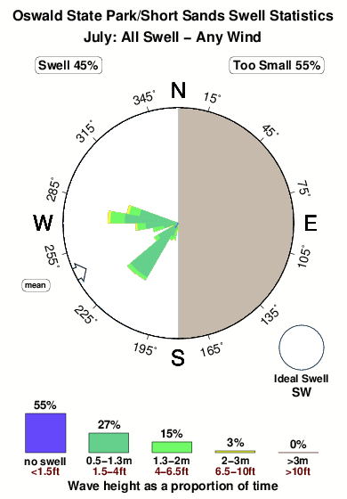
Período Dominante (s) 17 17 17 17 Overall Oswald State Park/Short Sands Surf Consistency and Wind Distribution in julio
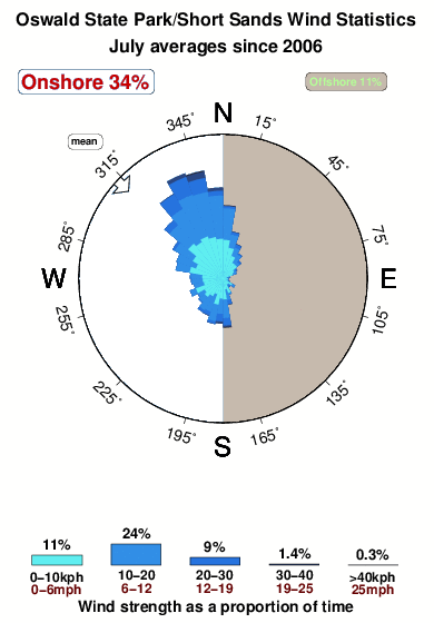


Wind stats for Oswald State Park/Short Sands: see the variation in direction and stength by month.
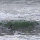
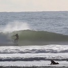
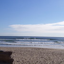
Fotos de Surf
de la galeríaContornos: Carreteras y Ríos: Selecciona un spot desde el menú 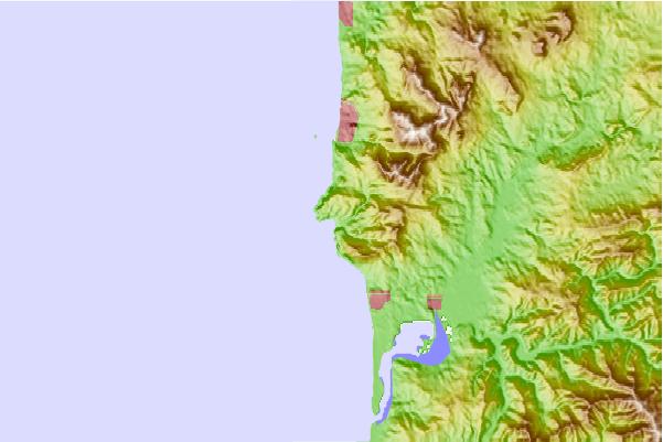
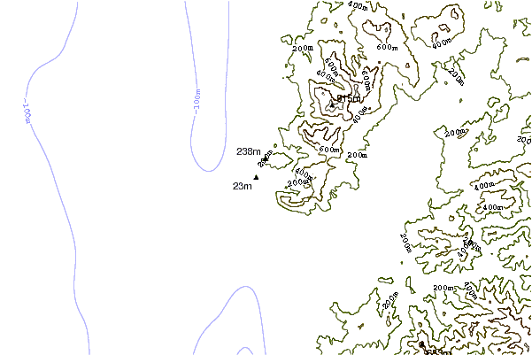
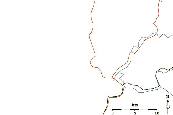
Usa este mapa para navegar hacia las playas de surf de Oregon North y estaciones de marea cercanas de Oswald State Park/Short Sands
Spots de Surf más cercanos a Oswald State Park/Short Sands:
(Clica la ubicación para más detalles)- Closest spot0 mi
- Second closest spot2 mi
- Third closest spot4 mi
- Fourth closest spot6 mi
- Fifth closest spot8 mi
Boyas marinas más cercanas a Oswald State Park/Short Sands:
- Closest Boya Marinas32 mi
- Second closest Boya Marinas37 mi
- Third closest Boya Marinas41 mi
- Fourth closest Boya Marinas77 mi
- Fifth closest Boya Marinas81 mi
Estaciones de marea más cercanas a Oswald State Park/Short Sands:
- Closest estación de mareaNehalem, Nehalem River5 mi
- Second closest estación de mareaBrighton, Nehalem River7 mi
- Third closest estación de mareaBarview, Tillamook Bay14 mi
- Fourth closest estación de mareaGaribaldi14 mi
- Fifth closest estación de mareaMiami Cove, Tillamook Bay15 mi
Airports
- The closest passenger airport to Oswald State Park/Short Sands is Scappoose Industrial Airpark (San Luis) Airport (SPB) in USA, 86 km (53 miles) away (directly).
- The second nearest airport to Oswald State Park/Short Sands is Mc Minnville Muni (Mackminnville) Airport (MMV), also in USA, 91 km (57 miles) away.
- Third is Portland International Airport (PDX) in USA, 108 km (67 miles) away.
- Gray Aaf (Fort Lewis) Airport (GRF) in USA is 181 km (112 miles) away.
- Mc Chord Afb (Tacoma) Airport (TCM), also in USA is the fifth nearest airport to Oswald State Park/Short Sands and is 191 km (119 miles) away.

- /breaks/Oswald-West-State-Park/forecasts/latest


 Nearest