

- Forecast
- Maps
- Live
- Weather State
- Spot Information

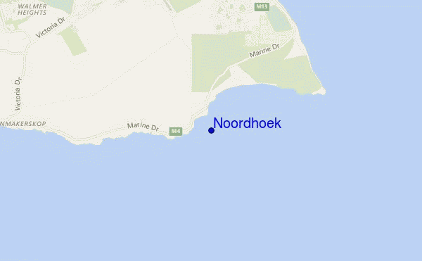
Noordhoek surf Forecast / Eastern Cape (S) / South Africa
- Map Icons:
 Break
Break Live Wave Height (m)
 Live Wind Speed (km/h)
 Surf Rating (10 Max)
 Ocean Swells (m)
- Wind Speed (km/h)
How big are the waves at Noordhoek today?
The current surf forecast for Noordhoek at 10AM is: 1.7m 7s primary swell from a South direction and 0.6m 11s secondary swell from a South direction (forecast issued at 07:00am April 26). An open ocean swell of 0.5m 7s is not directed at the surf break. The wind direction is predicted to be onshore.
| Time (SAST) & Date | Wave Height | Wave Period |
|---|---|---|
| Morning (26 Apr) | 5ft (1.6m) | 6s |
| Afternoon (26 Apr) | 6.5ft (2.0m) | 8s |
| Evening (26 Apr) | 6ft (1.8m) | 8s |
Table - waves today at Noordhoek. (Swell directed towards the surf break)
Friday 26 | Saturday 27 | Sunday 28 | Monday 29 | Tuesday 30 | Wednesday 01 | Thursday 02 | Friday 03 | |||||||||||||||||||||||||||||||||||||||||||||||||||||
| 5 AM | 8 AM | 11 AM | 2 PM | 5 PM | 8 PM | 11 PM | 2 AM | 5 AM | 8 AM | 11 AM | 2 PM | 5 PM | 8 PM | 11 PM | 2 AM | 5 AM | 8 AM | 11 AM | 2 PM | 5 PM | 8 PM | 11 PM | 2 AM | 5 AM | 8 AM | 11 AM | 2 PM | 5 PM | 8 PM | 11 PM | 2 AM | 5 AM | 8 AM | 11 AM | 2 PM | 5 PM | 8 PM | 11 PM | 2 AM | 5 AM | 8 AM | 11 AM | 2 PM | 5 PM | 8 PM | 11 PM | 2 AM | 5 AM | 8 AM | 11 AM | 2 PM | 5 PM | 8 PM | 11 PM | 2 AM | 5 AM | 8 AM | 11 AM | 2 PM | |
Rating (10 max) | ||||||||||||||||||||||||||||||||||||||||||||||||||||||||||||
Swell Height Map |    |    |    |  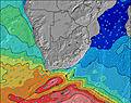 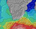 | 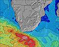   |   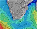 | 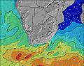 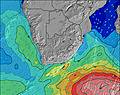 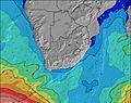 | 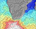   | ||||||||||||||||||||||||||||||||||||||||||||||||||||
| Wave Height (m) & direction (?) | ||||||||||||||||||||||||||||||||||||||||||||||||||||||||||||
| Period(s) (?) | 11 | 6 | 7 | 8 | 7 | 8 | 15 | 14 | 13 | 14 | 18 | 17 | 16 | 16 | 15 | 15 | 14 | 14 | 14 | 14 | 14 | 14 | 14 | 14 | 14 | 14 | 14 | 14 | 14 | 13 | 13 | 13 | 13 | 13 | 13 | 12 | 16 | 15 | 15 | 14 | 14 | 11 | 11 | 11 | 10 | 10 | 11 | 11 | 10 | 10 | 10 | 11 | 11 | 10 | 10 | 10 | 10 | 10 | 10 | 10 |
Wave (?)Graph | ||||||||||||||||||||||||||||||||||||||||||||||||||||||||||||
| Energy (?) | 308 | 167 | 347 | 446 | 278 | 427 | 568 | 671 | 651 | 1094 | 964 | 2378 | 2058 | 2007 | 1882 | 1488 | 1340 | 1126 | 1126 | 1042 | 1028 | 1049 | 1049 | 1080 | 988 | 988 | 988 | 877 | 799 | 651 | 560 | 501 | 488 | 374 | 277 | 252 | 231 | 275 | 343 | 333 | 394 | 690 | 743 | 730 | 649 | 587 | 573 | 573 | 471 | 435 | 358 | 322 | 275 | 290 | 245 | 245 | 240 | 200 | 167 | 158 |
Wind (km/h) | ||||||||||||||||||||||||||||||||||||||||||||||||||||||||||||
| Wind State (?) onshore cross-onshore cross-shore cross-offshore offshore glassy | cross- on | on | on | on | on | on | cross- on | cross- on | cross- on | cross- on | cross- on | cross- on | cross- on | cross- on | cross- on | cross | cross | cross | cross | cross- on | cross- on | cross- off | glass | cross- off | cross- off | cross- off | cross- off | cross | cross | cross- off | cross- off | cross- off | cross- off | cross- off | cross | cross | cross | cross- off | cross- off | cross- off | cross- off | cross- off | cross- off | cross | cross | cross | glass | cross- off | cross | cross | cross | cross- on | cross- on | cross- on | cross | cross | cross | cross | cross | cross- on |
High Tide / height (m) | 4:39AM 1.89 | 5:01PM 1.74 | 5:08AM 1.82 | 5:33PM 1.68 | 5:41AM 1.72 | 6:12PM 1.59 | 6:21AM 1.60 | 7:03PM 1.49 | 7:16AM 1.45 | 8:20PM 1.41 | 8:48AM 1.34 | 10:05PM 1.42 | 10:45AM 1.34 | 11:36PM 1.53 | 12:10PM 1.44 | |||||||||||||||||||||||||||||||||||||||||||||
Low Tide / height (m) | 10:50AM 0.33 | 10:55PM 0.44 | 11:21AM 0.38 | 11:28PM 0.52 | 11:55AM 0.47 | 12:06AM 0.63 | 12:36PM 0.58 | 12:57AM 0.75 | 1:33PM 0.70 | 2:21AM 0.86 | 3:05PM 0.78 | 4:38AM 0.85 | 5:02PM 0.75 | 6:13AM 0.70 | ||||||||||||||||||||||||||||||||||||||||||||||
Friday 26 | Saturday 27 | Sunday 28 | Monday 29 | Tuesday 30 | Wednesday 01 | Thursday 02 | Friday 03 | |||||||||||||||||||||||||||||||||||||||||||||||||||||
| Sunrise | - | 6:48 | - | - | - | - | - | - | - | 6:48 | - | - | - | - | - | - | - | 6:50 | - | - | - | - | - | - | - | 6:50 | - | - | - | - | - | - | - | 6:50 | - | - | - | - | - | - | - | 6:52 | - | - | - | - | - | - | - | 6:52 | - | - | - | - | - | - | - | 6:54 | - | - |
| Sunset | - | - | - | - | 5:40 | - | - | - | - | - | - | - | 5:39 | - | - | - | - | - | - | - | 5:37 | - | - | - | - | - | - | - | 5:37 | - | - | - | - | - | - | - | 5:36 | - | - | - | - | - | - | - | 5:35 | - | - | - | - | - | - | - | 5:34 | - | - | - | - | - | - | - |
Rain (mm) | 3 | 1 | 1 | - | - | - | - | - | - | - | - | - | - | - | - | - | - | - | - | - | - | - | - | - | 1 | 1 | - | - | - | - | - | - | - | - | - | - | - | - | - | - | - | - | - | - | - | - | - | - | - | - | - | - | - | - | - | - | - | - | - | - |
| Temp. °C | 19 | 20 | 19 | 19 | 19 | 19 | 19 | 19 | 18 | 18 | 18 | 18 | 19 | 19 | 18 | 17 | 17 | 17 | 20 | 24 | 23 | 22 | 26 | 23 | 21 | 18 | 20 | 20 | 19 | 18 | 18 | 17 | 18 | 18 | 19 | 19 | 19 | 19 | 18 | 17 | 17 | 17 | 18 | 19 | 18 | 18 | 17 | 17 | 17 | 17 | 18 | 20 | 20 | 20 | 20 | 19 | 18 | 18 | 21 | 24 |
| Feels °C (?) | 18 | 18 | 15 | 15 | 16 | 16 | 16 | 15 | 14 | 14 | 13 | 12 | 13 | 13 | 12 | 11 | 11 | 14 | 17 | 22 | 21 | 22 | 27 | 22 | 20 | 17 | 19 | 18 | 18 | 19 | 19 | 17 | 18 | 17 | 18 | 17 | 18 | 19 | 17 | 16 | 15 | 15 | 16 | 16 | 16 | 18 | 17 | 17 | 17 | 16 | 15 | 16 | 15 | 16 | 17 | 16 | 16 | 16 | 18 | 21 |
FREE! Surf-Forecast.com widget for your website
The surf report / weather widget below is available to embed on third party websites free of charge and provides a summary of our Noordhoek surf forecast. Simply grab the html code snippet that we provide and paste it into your own site. You can choose your preferred language and metric/imperial units for the surf forecast feed to suit users of your site. Click here to get the code.


 Nearest