
Previsiones:

Pronóstico Corto PlazoFuerte lluvia (totál 34mm), más pesada durante la mañana del viernes. Warm (max 28°C el jueves por la tarde, min 25°C el viernes por la tarde). Vientos decreciente (vientos fuertes desde el ESE el viernes por la tarde, Vientos ligeros desde el E por la mañana de domingo). | |||||||||||||||||||||
jue 30 | viernes 31 | sábado 1 | |||||||||||||||||||
11 AM | 2 PM | 5 PM | 8 PM | 11 PM | 2 AM | 5 AM | 8 AM | 11 AM | 2 PM | 5 PM | 8 PM | 11 PM | 2 AM | 5 AM | 8 AM | 11 AM | 2 PM | 5 PM | 8 PM | 11 PM | |
Mapa de Altura de Olas | 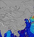 | 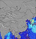 | 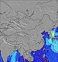 | 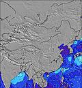 | 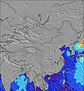 | 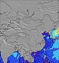 | 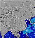 | 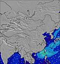 | |||||||||||||
Oleaje Altura (m) Dirección Período (s) | S 8 | S 8 | S 7 | S 7 | E 10 | E 10 | E 10 | E 10 | ESE 3 | ESE 3 | ESE 3 | ESE 3 | SE 3 | E 10 | S 7 | S 7 | ENE 3 | E 3 | E 3 | E 3 | E 5 |
Gráfico Olas | |||||||||||||||||||||
4 | 4 | 4 | 4 | 2 | 2 | 2 | 2 | 2 | 4 | 5 | 4 | 2 | 2 | 1 | 1 | 2 | 2 | 2 | 3 | 28 | |
Viento (km/h) | |||||||||||||||||||||
Estado del Viento Viento de Mar Viento de Mar-Cruzado Cruzado Viento de Tierra-Cruzado Viento de Tierra Cristalino | cross-on | cross-on | cross-on | cross | cross-on | cross | cross-on | cross | cross | cross-on | cross-on | cross-on | cross-on | cross | cross | cross | cross | cross | cross-on | cross-on | cross-on |
Marea alta | 00:17AM0.73m | 10:40AM1.60m | 00:12AM0.79m | 11:15AM1.56m | |||||||||||||||||
Marea baja | 5:50PM0.09m | 4:30AM0.55m | 6:20PM0.10m | 5:16AM0.52m | 6:50PM0.13m | ||||||||||||||||
— | — | — | — | — | — | 5:54 | — | — | — | — | — | — | — | 5:54 | — | — | — | — | — | — | |
— | — | 7:06 | — | — | — | — | — | — | — | 7:05 | — | — | — | — | — | — | — | 7:05 | — | — | |
mm | — | — | 1 | — | — | — | 2 | 5 | 3 | 1 | 1 | — | — | 3 | 4 | 5 | 1 | — | — | — | — |
Temp. °C | 28 | 28 | 28 | 27 | 27 | 27 | 27 | 27 | 26 | 26 | 25 | 26 | 27 | 26 | 26 | 25 | 26 | 26 | 27 | 27 | 27 |
Enfriamiento °C | 30 | 29 | 28 | 28 | 29 | 29 | 29 | 29 | 25 | 24 | 22 | 25 | 28 | 29 | 28 | 26 | 27 | 26 | 27 | 27 | 29 |
Oleaje 1 Altura (m) Dirección Período (s) | S 8 | S 8 | S 7 | S 7 | S 8 | S 8 | S 8 | S 8 | S 8 | S 7 | S 7 | S 7 | S 7 | S 7 | — | S 7 | S 7 | S 7 | S 7 | S 8 | S 7 |
4 | 4 | 4 | 4 | 1 | 1 | 1 | 1 | 1 | 1 | 1 | 1 | 1 | 1 | — | 1 | 1 | 1 | 1 | 1 | 4 | |
Oleaje 2 Altura (m) Dirección Período (s) | SE 10 | SE 10 | SE 10 | SE 10 | E 10 | E 10 | E 10 | E 10 | — | — | — | E 10 | E 9 | E 9 | S 7 | — | E 9 | E 9 | E 9 | E 9 | E 5 |
4 | 4 | 4 | 4 | 2 | 2 | 2 | 2 | — | — | — | 2 | 2 | 2 | 1 | — | 2 | 2 | 2 | 2 | 28 | |
Oleaje 3 Altura (m) Dirección Período (s) | SE 10 | — | — | — | — | — | — | — | — | — | — | — | — | E 10 | S 6 | — | — | — | — | E 9 | E 10 |
4 | — | — | — | — | — | — | — | — | — | — | — | — | 2 | 1 | — | — | — | — | 2 | 2 | |
Olas de Viento Altura (m) Dirección Período (s) | — | ESE 2 | ESE 3 | E 3 | E 3 | E 3 | E 3 | E 3 | ESE 3 | ESE 3 | ESE 3 | ESE 3 | SE 3 | SE 3 | — | — | ENE 3 | E 3 | E 3 | E 3 | E 3 |
— | 1 | 2 | 2 | 1 | 1 | 1 | 1 | 2 | 4 | 5 | 4 | 2 | 1 | — | — | 2 | 2 | 2 | 3 | 1 | |
Viento del Tierra o Mar Limpio más proximo | |||||||||||||||||||||
Distancia (km) | 559 | 559 | 597 | 2308 | 827 | 827 | 855 | 867 | 855 | 559 | 779 | 779 | 699 | 2254 | 2254 | 2254 | 597 | 559 | 559 | 1455 | 1477 |
Mejores Olas Previstas en Hong Kong | |||||||||||||||||||||
Mejores Olas Previstas en China | |||||||||||||||||||||
Busca-Olas Global | |||||||||||||||||||||
- Map Icons:
 Break
Break Live Wave Height (m)
 Live Wind Speed (km/h)
 Surf Rating (10 Max)
 Ocean Swells (m)
- Wind Speed (km/h)
GRÁTIS! Un widget de Surf-Forecast.com para tu sitio
Este widget grátis de previsiones de surf y tiempo puede ser añadido a cualquier otro sitio y da un resumen de previsiones de olas para Lantau Island. Solo necesita cortar y pegar el código HTML de abajo en su web. Puede elegir preferencias de idioma y de unidades (métricas o imperiales) para convenir a los usuarios de su sitio. Clica aquí para obtener el código.
 Nearest