
Previsiones:

Pronóstico Corto PlazoMayormente seco. Warm (max 29°C el viernes por la tarde, min 25°C el jueves por la mañana). El viento será generalmente ligero. | ||||||||||||||||||||||||
jueves 30 | viernes 31 | sábado 1 | ||||||||||||||||||||||
2 AM | 5 AM | 8 AM | 11 AM | 2 PM | 5 PM | 8 PM | 11 PM | 2 AM | 5 AM | 8 AM | 11 AM | 2 PM | 5 PM | 8 PM | 11 PM | 2 AM | 5 AM | 8 AM | 11 AM | 2 PM | 5 PM | 8 PM | 11 PM | |
Mapa de Altura de Olas | 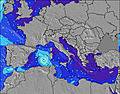 | 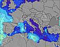 | 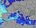 | 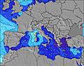 | 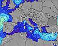 | 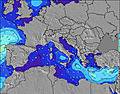 | 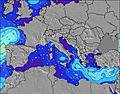 | 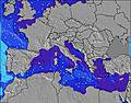 | 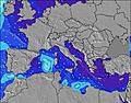 | |||||||||||||||
Oleaje Altura (m) Dirección Período (s) | NW 4 | NW 3 | — | — | — | NW 3 | NNW 3 | NW 3 | NNW 3 | NNW 3 | — | — | NW 2 | NNW 3 | NNW 4 | NNW 4 | NW 3 | NNW 3 | — | — | NW 3 | NW 3 | NNW 4 | NNW 3 |
Gráfico Olas | ||||||||||||||||||||||||
2 | 2 | 0 | 0 | 0 | 2 | 4 | 3 | 1 | 1 | 0 | 0 | 2 | 0 | 12 | 0 | 3 | 1 | 0 | 0 | 2 | 5 | 0 | 5 | |
Viento (km/h) | ||||||||||||||||||||||||
Estado del Viento Viento de Mar Viento de Mar-Cruzado Cruzado Viento de Tierra-Cruzado Viento de Tierra Cristalino | glassy | glassy | cross-off | on | cross-on | cross | cross-on | glassy | glassy | off | glassy | cross-on | cross-on | cross | cross | cross | off | cross-off | cross-off | cross | cross-on | cross | cross | cross |
Marea alta | 9:58AM0.19m | 11:07PM0.28m | 10:33AM0.19m | 11:35PM0.28m | 11:09AM0.19m | |||||||||||||||||||
Marea baja | 4:54AM0.09m | 4:10PM0.01m | 5:25AM0.08m | 4:41PM0.01m | 5:56AM0.08m | 5:12PM0.02m | ||||||||||||||||||
— | 6:22 | — | — | — | — | — | — | — | 6:22 | — | — | — | — | — | — | — | 6:24 | — | — | — | — | — | — | |
— | — | — | — | — | — | 8:42 | — | — | — | — | — | — | — | 8:40 | — | — | — | — | — | — | — | 8:39 | — | |
mm | — | — | — | — | — | — | — | — | — | — | — | — | — | — | — | — | — | — | — | — | — | — | — | — |
Temp. °C | 25 | 25 | 25 | 28 | 28 | 28 | 27 | 26 | 26 | 25 | 26 | 28 | 29 | 28 | 27 | 27 | 26 | 26 | 26 | 29 | 28 | 28 | 26 | 26 |
Enfriamiento °C | 29 | 28 | 27 | 30 | 29 | 29 | 30 | 30 | 30 | 28 | 29 | 29 | 29 | 27 | 28 | 29 | 28 | 27 | 26 | 28 | 27 | 28 | 27 | 27 |
Oleaje 1 Altura (m) Dirección Período (s) | NW 4 | NW 3 | — | — | — | — | — | NNW 3 | NNW 3 | NNW 3 | — | — | — | — | — | — | NW 3 | NNW 3 | — | — | — | — | — | — |
2 | 2 | — | — | — | — | — | 2 | 1 | 1 | — | — | — | — | — | — | 3 | 1 | — | — | — | — | — | — | |
Oleaje 2 Altura (m) Dirección Período (s) | — | — | — | — | — | — | — | — | — | — | — | — | — | — | — | — | — | — | — | — | — | — | — | — |
— | — | — | — | — | — | — | — | — | — | — | — | — | — | — | — | — | — | — | — | — | — | — | — | |
Oleaje 3 Altura (m) Dirección Período (s) | — | — | — | — | — | — | — | — | — | — | — | — | — | — | — | — | — | — | — | — | — | — | — | — |
— | — | — | — | — | — | — | — | — | — | — | — | — | — | — | — | — | — | — | — | — | — | — | — | |
Olas de Viento Altura (m) Dirección Período (s) | — | — | — | — | — | NW 3 | NNW 3 | NW 3 | — | — | — | — | NW 2 | NNW 3 | NNW 4 | NNW 4 | — | — | — | — | NW 3 | NW 3 | NNW 4 | NNW 3 |
— | — | — | — | — | 2 | 4 | 3 | — | — | — | — | 2 | 6 | 12 | 8 | — | — | — | — | 2 | 5 | 7 | 5 | |
Viento del Tierra o Mar Limpio más proximo | ||||||||||||||||||||||||
Distancia (km) | 1002 | 1021 | 913 | 1102 | 998 | 998 | 998 | 746 | 953 | 940 | 913 | 917 | 1263 | 1263 | 1263 | 432 | 417 | 424 | 913 | 918 | 998 | 1070 | 1103 | 940 |
Mejores Olas Previstas en Sardinia | ||||||||||||||||||||||||
Mejores Olas Previstas en Italy | ||||||||||||||||||||||||
Busca-Olas Global | ||||||||||||||||||||||||
- Map Icons:
 Break
Break Live Wave Height (m)
 Live Wind Speed (km/h)
 Surf Rating (10 Max)
 Ocean Swells (m)
- Wind Speed (km/h)
GRÁTIS! Un widget de Surf-Forecast.com para tu sitio
Este widget grátis de previsiones de surf y tiempo puede ser añadido a cualquier otro sitio y da un resumen de previsiones de olas para La Laguna. Solo necesita cortar y pegar el código HTML de abajo en su web. Puede elegir preferencias de idioma y de unidades (métricas o imperiales) para convenir a los usuarios de su sitio. Clica aquí para obtener el código.
 Nearest