
La Cienega Surf Guide
La Cienega on the South Coast is an exposed beach break that has quite reliable surf The best wind direction is from the northwest. Tends to receive a mix of groundswells and windswells and the best swell direction is from the southeast. Waves at the beach tend to peel to the left. Best around low tide when the tide is rising. Rarely crowded here.
La Cienega Spot Info
| Type: | Rating: | Reliability: | Todays Sea Temp*: |
|---|---|---|---|
| fairly consistent | 28.9°C*ocean temperature recorded from satellite |
Surfing La Cienega:
The best conditions reported for surf at La Cienega occur when a Southeast swell combines with an offshore wind direction from the Northwest.

Energía de Olas (poder): 12 horas


La Cienega Surf:
Thursday, 30 July 2026, 00:38 Local time| mié | jueves 30 | |||
| 11PM | 2AM | 5AM | 8AM | |
| Wave (m) | ||||
| Período (s) | 6 | 6 | 6 | 7 |
| Viento (km/h) | ||||
| Estado del Viento | cross | cross | cross- on |
cross- on |
- /breaks/La-Cienega/forecasts/latest
La Cienega Surf Guide
La Cienega on the South Coast is an exposed beach break that has quite reliable surf The best wind direction is from the northwest. Tends to receive a mix of groundswells and windswells and the best swell direction is from the southeast. Waves at the beach tend to peel to the left. Best around low tide when the tide is rising. Rarely crowded here.
La Cienega Spot Info
Type: Rating: Reliability: Todays Sea Temp*:  Beach
Beach 3
3fairly consistent 28.9°C*ocean temperature recorded from satelliteSurfing La Cienega:
The best conditions reported for surf at La Cienega occur when a Southeast swell combines with an offshore wind direction from the Northwest.
Energía de Olas (poder): 12 horas
Usa la barra de navegación de arriba para ver la temperatura del mar en La Cienega, fotografías La Cienega, previsiones detalladas de olas para La Cienega, vientos y previsión del tiempo, webcams para La Cienega, viento actual desde estaciones meteorológicas en Caribbean Coast y predicciones de marea para La Cienega. Las mapas de olas para Dominican Republic enseñarán un mapa grande de Dominican Republic y los mares que rodean. Los mapas de olas pueden ser animadas para mostrar diferentes componentes de olas, la altura de ola, la energía de ola, el período, junto con previsiones de viento y del tiempo. Previsiones actuales del tiempo y del estado del mar provienen de boyas marinas de Dominican Republic, del barcos que transitan en la zona y de estaciones meteorológicas costeras. Cada página de previsiones tiene un Busca-Olas Regional y Global para localizar las mejores condiciones para surfear en el área de La Cienega.
La Cienega Surf:
Thursday, 30 July 2026, 00:38 Local timemié jueves 30 11PM 2AM 5AM 8AM Wave (m) Período (s) 6 6 6 7 Viento (km/h) Estado del Viento cross cross cross-
oncross-
on- /breaks/La-Cienega/forecasts/latest
- /breaks/La-Cienega/forecasts/latest/six_day
La Cienega Surf Guide
La Cienega on the South Coast is an exposed beach break that has quite reliable surf The best wind direction is from the northwest. Tends to receive a mix of groundswells and windswells and the best swell direction is from the southeast. Waves at the beach tend to peel to the left. Best around low tide when the tide is rising. Rarely crowded here.
La Cienega Spot Info
Type: Rating: Reliability: Todays Sea Temp*: Beach3fairly consistent 28.9°C*ocean temperature recorded from satelliteSurfing La Cienega:
The best conditions reported for surf at La Cienega occur when a Southeast swell combines with an offshore wind direction from the Northwest.
Energía de Olas (poder): 12 horas
Usa la barra de navegación de arriba para ver la temperatura del mar en La Cienega, fotografías La Cienega, previsiones detalladas de olas para La Cienega, vientos y previsión del tiempo, webcams para La Cienega, viento actual desde estaciones meteorológicas en Caribbean Coast y predicciones de marea para La Cienega. Las mapas de olas para Dominican Republic enseñarán un mapa grande de Dominican Republic y los mares que rodean. Los mapas de olas pueden ser animadas para mostrar diferentes componentes de olas, la altura de ola, la energía de ola, el período, junto con previsiones de viento y del tiempo. Previsiones actuales del tiempo y del estado del mar provienen de boyas marinas de Dominican Republic, del barcos que transitan en la zona y de estaciones meteorológicas costeras. Cada página de previsiones tiene un Busca-Olas Regional y Global para localizar las mejores condiciones para surfear en el área de La Cienega.
La Cienega Surf:
Thursday, 30 July 2026, 00:38 Local timemié jueves 30 11PM 2AM 5AM 8AM Wave (m) Período (s) 6 6 6 7 Viento (km/h) Estado del Viento cross cross cross-
oncross-
on- /breaks/La-Cienega/forecasts/latest
La Cienega Surf Guide
La Cienega on the South Coast is an exposed beach break that has quite reliable surf The best wind direction is from the northwest. Tends to receive a mix of groundswells and windswells and the best swell direction is from the southeast. Waves at the beach tend to peel to the left. Best around low tide when the tide is rising. Rarely crowded here.
La Cienega Spot Info
Type: Rating: Reliability: Todays Sea Temp*: Beach3fairly consistent 28.9°C*ocean temperature recorded from satelliteSurfing La Cienega:
The best conditions reported for surf at La Cienega occur when a Southeast swell combines with an offshore wind direction from the Northwest.
Energía de Olas (poder): 12 horas
Usa la barra de navegación de arriba para ver la temperatura del mar en La Cienega, fotografías La Cienega, previsiones detalladas de olas para La Cienega, vientos y previsión del tiempo, webcams para La Cienega, viento actual desde estaciones meteorológicas en Caribbean Coast y predicciones de marea para La Cienega. Las mapas de olas para Dominican Republic enseñarán un mapa grande de Dominican Republic y los mares que rodean. Los mapas de olas pueden ser animadas para mostrar diferentes componentes de olas, la altura de ola, la energía de ola, el período, junto con previsiones de viento y del tiempo. Previsiones actuales del tiempo y del estado del mar provienen de boyas marinas de Dominican Republic, del barcos que transitan en la zona y de estaciones meteorológicas costeras. Cada página de previsiones tiene un Busca-Olas Regional y Global para localizar las mejores condiciones para surfear en el área de La Cienega.
La Cienega Surf:
Thursday, 30 July 2026, 00:38 Local timemié jueves 30 11PM 2AM 5AM 8AM Wave (m) Período (s) 6 6 6 7 Viento (km/h) Estado del Viento cross cross cross-
oncross-
onTide Times:
Para Enriquillo, a %{dist} %{km} de %{location}.
PROXIMA ES A LAS (hora local) quedan marea alta marea baja La Cienega Tide Times and Tide Chart
Live Weather:
At Bella Vista wx, 152 km from La Cienega.
calm
(km/h)
dryAir temperature
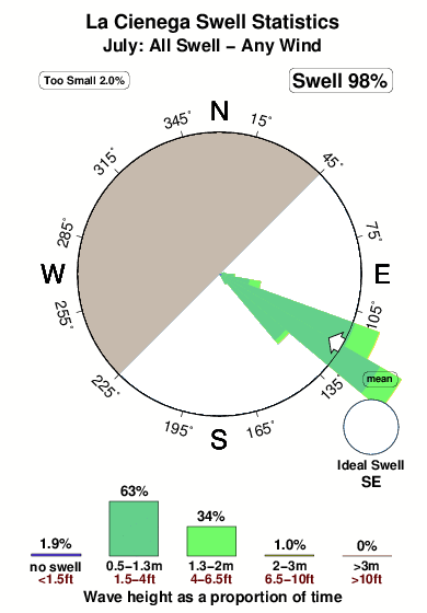
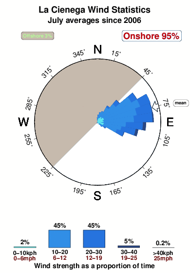
29°COverall La Cienega Surf Consistency and Wind Distribution in julio
Fotos de Surf
de la galeríaContornos: Carreteras y Ríos: Selecciona un spot desde el menú 


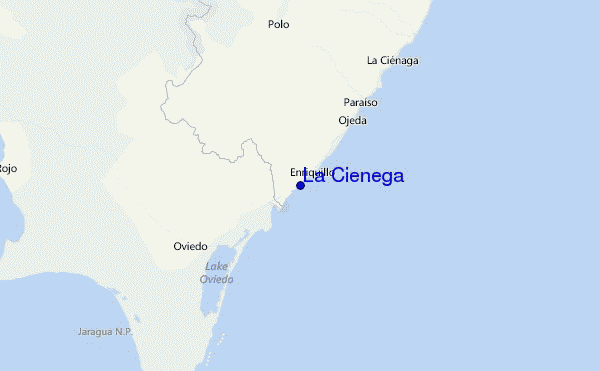
Usa este mapa para navegar hacia las playas de surf de Caribbean Coast y estaciones de marea cercanas de La Cienega
Spots de Surf más cercanos a La Cienega:
(Clica la ubicación para más detalles)- Closest spot6 mi
- Second closest spot7 mi
- Third closest spot10 mi
- Fourth closest spot18 mi
- Fifth closest spot21 mi
Boyas marinas más cercanas a La Cienega:
- Closest Boya Marinas263 mi
- Second closest Boya Marinas311 mi
- Third closest Boya Marinas341 mi
- Fourth closest Boya Marinas382 mi
- Fifth closest Boya Marinas415 mi
Estaciones de marea más cercanas a La Cienega:
- Closest estación de mareaEnriquillo2 mi
- Second closest estación de mareaParaiso10 mi
- Third closest estación de mareaBarahona25 mi
- Fourth closest estación de mareaPedernales34 mi
- Fifth closest estación de mareaPaya68 mi
Airports
- The closest passenger airport to La Cienega is Maria Montez International (Barahona) Airport (BRX) in Dominican Republic, 43 km (27 miles) away (directly).
- The second nearest airport to La Cienega is Port Au Prince International (Port-au-prince) Airport (PAP) in Haiti, 135 km (84 miles) away.
- Third is Herrera International (Santo Domingo) Airport (HEX) in Dominican Republic, 151 km (94 miles) away.
- Las Americas International (Santo Domingo) Airport (SDQ) in Dominican Republic is 178 km (111 miles) away.
- Cibao International (Santiago) Airport (STI), also in Dominican Republic is the fifth nearest airport to La Cienega and is 183 km (114 miles) away.

- /breaks/La-Cienega/forecasts/latest


 Nearest