- Forecast
- Maps
- Live
- Weather State
- Spot Information
Previsiones:

Surf en Green islandPronóstico / South / Taiwan
Actualizacion del pronostico en hora min s Forecast update imminent
La altura de oleaje para Green island es en mar abierto. Olas rompiendo en la orilla/arrecife son usualmente más pequeñas en áreas protegidas.
La temperatura del mar en Green island hoy es
27.2° C
(Lo cual es 2.5°C más cálido de lo normal para esta época del año)Actualizaciones en hora min s Forecast update imminent
viernes 06 | sábado 07 | domingo 08 | lunes 09 | |||||||||||||||||||||
| 5 PM | 8 PM | 11 PM | 2 AM | 5 AM | 8 AM | 11 AM | 2 PM | 5 PM | 8 PM | 11 PM | 2 AM | 5 AM | 8 AM | 11 AM | 2 PM | 5 PM | 8 PM | 11 PM | 2 AM | 5 AM | 8 AM | 11 AM | 2 PM | |
Notación (10 max) | ||||||||||||||||||||||||
Mapa de Altura de Olas | 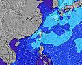   |  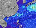 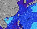 | 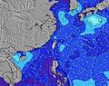 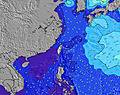  |    | ||||||||||||||||||||
| Altura de Olas (m) & dirección (?) | ||||||||||||||||||||||||
| Período(s) (?) | 7 | 8 | 9 | 9 | 10 | 10 | 9 | 9 | 9 | 9 | 9 | 9 | 9 | 9 | 9 | 9 | 8 | 8 | 8 | 8 | 8 | 8 | 8 | 8 |
Gráfico (?)Olas | ||||||||||||||||||||||||
| 524 | 0 | 0 | 0 | 0 | 0 | 0 | 0 | 0 | 2570 | 2344 | 1872 | 1573 | 1367 | 1146 | 1011 | 840 | 800 | 807 | 742 | 701 | 643 | 619 | 551 | |
Viento (km/h) | ||||||||||||||||||||||||
| Estado del Viento (?) onshore Viento de Mar-Cruzado Cruzado Viento de Tierra-Cruzado Viento de Tierra Cristalino | cross- off | cross- off | cross- off | cross- off | cross- off | cross- off | cross- off | cross- off | cross- off | cross- off | cross- off | cross- off | cross- off | cross- off | cross- off | cross- off | cross- off | cross- off | cross- off | cross- off | cross- off | cross- off | cross- off | cross- off |
Marea alta / altura (m) | 7:56PM 1.39 | 8:01AM 1.42 | 8:30PM 1.27 | 8:27AM 1.41 | 9:04PM 1.14 | 8:54AM 1.37 | ||||||||||||||||||
Marea baja / altura (m) | 1:54AM 0.36 | 2:20PM 0.27 | 2:16AM 0.45 | 2:57PM 0.33 | 2:36AM 0.54 | |||||||||||||||||||
viernes 06 | sábado 07 | domingo 08 | lunes 09 | |||||||||||||||||||||
| Amanecer | - | - | - | - | - | 6:09 | - | - | - | - | - | - | - | 6:09 | - | - | - | - | - | - | - | 6:07 | - | - |
| Puesta del Sol | 5:59 | - | - | - | - | - | - | - | 5:59 | - | - | - | - | - | - | - | 6:00 | - | - | - | - | - | - | - |
Lluvia (mm) | - | 1 | 1 | - | - | - | - | - | - | - | 1 | 1 | 1 | - | 1 | - | 1 | 1 | 1 | 2 | 2 | 1 | 1 | - |
| Temp. °C | 24 | 22 | 21 | 21 | 21 | 21 | 21 | 21 | 20 | 20 | 20 | 20 | 21 | 21 | 22 | 22 | 22 | 22 | 22 | 22 | 22 | 22 | 22 | 22 |
| Feels °C (?) | 18 | 13 | 11 | 11 | 11 | 11 | 11 | 11 | 9 | 10 | 11 | 12 | 14 | 14 | 17 | 17 | 17 | 17 | 18 | 18 | 18 | 17 | 17 | 18 |
- Map Icons:
 Break
Break Live Wave Height (m)
 Live Wind Speed (km/h)
 Surf Rating (10 Max)
 Ocean Swells (m)
- Wind Speed (km/h)
GRÁTIS! Un widget de Surf-Forecast.com para tu sitio
Este widget grátis de previsiones de surf y tiempo puede ser añadido a cualquier otro sitio y da un resumen de previsiones de olas para Green island. Solo necesita cortar y pegar el código HTML de abajo en su web. Puede elegir preferencias de idioma y de unidades (métricas o imperiales) para convenir a los usuarios de su sitio. Clica aquí para obtener el código.
 Nearest