- Forecast
- Maps
- Live
- Weather State
- Spot Information
Glenfield Previsión de Olas
/ WA – North West (27 breaks) / Western Australia (159 breaks) /Previsiones:

Surf en GlenfieldPronóstico / WA – North West / Australia
Actualizacion del pronostico en hora min s Forecast update imminent
La altura de oleaje para Glenfield es en mar abierto. Olas rompiendo en la orilla/arrecife son usualmente más pequeñas en áreas protegidas.
La temperatura del mar en Glenfield hoy es
23.7° C
(Lo cual es normal para esta época del año)Actualizaciones en hora min s Forecast update imminent
domingo 22 | lunes 23 | martes 24 | miércoles 25 | |||||||||||||||||||||
| 11 AM | 2 PM | 5 PM | 8 PM | 11 PM | 2 AM | 5 AM | 8 AM | 11 AM | 2 PM | 5 PM | 8 PM | 11 PM | 2 AM | 5 AM | 8 AM | 11 AM | 2 PM | 5 PM | 8 PM | 11 PM | 2 AM | 5 AM | 8 AM | |
Notación (10 max) | ||||||||||||||||||||||||
Mapa de Altura de Olas |    |  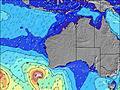 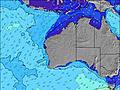 |  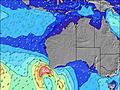 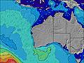 |  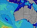 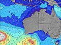 | ||||||||||||||||||||
| Altura de Olas (m) & dirección (?) | ||||||||||||||||||||||||
| Período(s) (?) | 17 | 16 | 16 | 16 | 15 | 15 | 14 | 14 | 14 | 14 | 14 | 14 | 14 | 14 | 13 | 13 | 14 | 15 | 16 | 16 | 15 | 15 | 14 | 14 |
Gráfico (?)Olas | ||||||||||||||||||||||||
| 2044 | 3559 | 4355 | 4244 | 1833 | 1661 | 1616 | 2265 | 2085 | 2056 | 2037 | 1004 | 813 | 647 | 628 | 570 | 632 | 1597 | 2465 | 2285 | 2325 | 1915 | 1602 | 1580 | |
Viento (km/h) | ||||||||||||||||||||||||
| Estado del Viento (?) onshore Viento de Mar-Cruzado Cruzado Viento de Tierra-Cruzado Viento de Tierra Cristalino | cross | cross | cross | cross | cross | cross | cross | cross | cross | cross- on | cross | cross | cross | cross | cross | cross | cross- on | cross- on | cross- on | cross | cross | cross | cross- on | cross |
Marea alta / altura (m) | 1:11PM 0.60 | 2:10AM 0.26 | 1:45PM 0.64 | 2:37PM 0.66 | ||||||||||||||||||||
Marea baja / altura (m) | 8:12PM 0.24 | 5:39AM 0.23 | 1:31AM 0.17 | 2:17AM 0.10 | ||||||||||||||||||||
domingo 22 | lunes 23 | martes 24 | miércoles 25 | |||||||||||||||||||||
| Amanecer | - | - | - | - | - | - | - | 6:07 | - | - | - | - | - | - | - | 6:09 | - | - | - | - | - | - | - | 6:09 |
| Puesta del Sol | - | - | 7:00 | - | - | - | - | - | - | - | 7:00 | - | - | - | - | - | - | - | 6:59 | - | - | - | - | - |
Lluvia (mm) | - | - | - | - | - | - | - | - | - | - | - | - | - | - | - | - | - | - | - | - | - | - | - | - |
| Temp. °C | 26 | 27 | 24 | 22 | 21 | 22 | 22 | 24 | 28 | 27 | 25 | 22 | 22 | 22 | 22 | 23 | 27 | 27 | 25 | 24 | 24 | 24 | 23 | 25 |
| Feels °C (?) | 22 | 22 | 19 | 17 | 17 | 19 | 18 | 20 | 26 | 23 | 21 | 18 | 18 | 18 | 20 | 21 | 26 | 26 | 24 | 23 | 25 | 25 | 23 | 25 |
- Map Icons:
 Break
Break Live Wave Height (m)
 Live Wind Speed (km/h)
 Surf Rating (10 Max)
 Ocean Swells (m)
- Wind Speed (km/h)
GRÁTIS! Un widget de Surf-Forecast.com para tu sitio
Este widget grátis de previsiones de surf y tiempo puede ser añadido a cualquier otro sitio y da un resumen de previsiones de olas para Glenfield. Solo necesita cortar y pegar el código HTML de abajo en su web. Puede elegir preferencias de idioma y de unidades (métricas o imperiales) para convenir a los usuarios de su sitio. Clica aquí para obtener el código.
 Nearest