

- Forecast
- Maps
- Live
- Weather State
- Spot Information
Duranbah Surf Forecast
/ QLD – Gold Coast (23 breaks) / New South Wales (297 breaks) /

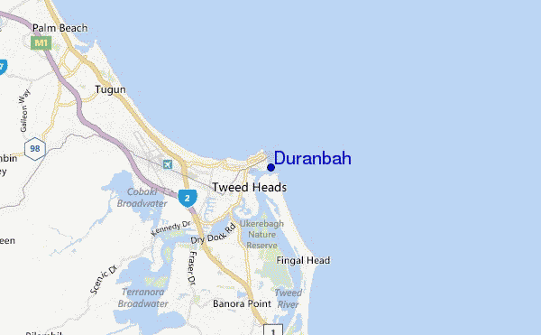
Duranbah surf Forecast / QLD – Gold Coast / Australia
- Map Icons:
 Break
Break Live Wave Height (m)
 Live Wind Speed (km/h)
 Surf Rating (10 Max)
 Ocean Swells (m)
- Wind Speed (km/h)
How big are the waves at Duranbah today?
The current surf forecast for Duranbah at 9AM is: 1.4m 9s primary swell from a South-southeast direction and 0.7m 9s secondary swell from a East direction, 0.6m 15s secondary swell from a South-southeast direction (forecast issued at 03:00am April 27). The wind direction is predicted to be cross-offshore and the swell rating is 2.
| Time (AEST) & Date | Wave Height | Wave Period |
|---|---|---|
| Morning (27 Apr) | 4.5ft (1.4m) | 9s |
| Afternoon (27 Apr) | 4.5ft (1.3m) | 9s |
| Evening (27 Apr) | 4.5ft (1.4m) | 10s |
Table - waves today at Duranbah. (Swell directed towards the surf break)
Saturday 27 | Sunday 28 | Monday 29 | Tuesday 30 | Wednesday 01 | Thursday 02 | Friday 03 | Saturday 04 | |||||||||||||||||||||||||||||||||||||||||||||||||||||
| 1 AM | 4 AM | 7 AM | 10 AM | 1 PM | 4 PM | 7 PM | 10 PM | 1 AM | 4 AM | 7 AM | 10 AM | 1 PM | 4 PM | 7 PM | 10 PM | 1 AM | 4 AM | 7 AM | 10 AM | 1 PM | 4 PM | 7 PM | 10 PM | 1 AM | 4 AM | 7 AM | 10 AM | 1 PM | 4 PM | 7 PM | 10 PM | 1 AM | 4 AM | 7 AM | 10 AM | 1 PM | 4 PM | 7 PM | 10 PM | 1 AM | 4 AM | 7 AM | 10 AM | 1 PM | 4 PM | 7 PM | 10 PM | 1 AM | 4 AM | 7 AM | 10 AM | 1 PM | 4 PM | 7 PM | 10 PM | 1 AM | 4 AM | 7 AM | 10 AM | |
Rating (10 max) | ||||||||||||||||||||||||||||||||||||||||||||||||||||||||||||
Swell Height Map |    |    |    |    |    |    |    |    | ||||||||||||||||||||||||||||||||||||||||||||||||||||
| Wave Height (m) & direction (?) | ||||||||||||||||||||||||||||||||||||||||||||||||||||||||||||
| Period(s) (?) | 10 | 16 | 9 | 9 | 9 | 9 | 10 | 10 | 10 | 10 | 10 | 10 | 10 | 10 | 10 | 10 | 9 | 9 | 9 | 6 | 7 | 7 | 8 | 8 | 8 | 8 | 8 | 8 | 8 | 8 | 8 | 8 | 8 | 8 | 8 | 8 | 6 | 7 | 7 | 7 | 8 | 8 | 8 | 8 | 8 | 8 | 8 | 8 | 8 | 8 | 8 | 8 | 8 | 8 | 8 | 7 | 8 | 8 | 8 | 8 |
Wave (?)Graph | ||||||||||||||||||||||||||||||||||||||||||||||||||||||||||||
| Energy (?) | 192 | 173 | 380 | 340 | 287 | 268 | 339 | 356 | 253 | 253 | 248 | 123 | 123 | 96 | 96 | 177 | 170 | 216 | 211 | 104 | 114 | 155 | 198 | 196 | 163 | 159 | 172 | 191 | 157 | 148 | 146 | 117 | 119 | 133 | 109 | 107 | 219 | 408 | 381 | 532 | 787 | 910 | 807 | 845 | 734 | 480 | 531 | 754 | 765 | 799 | 749 | 671 | 585 | 555 | 514 | 515 | 745 | 706 | 609 | 635 |
Wind (km/h) | ||||||||||||||||||||||||||||||||||||||||||||||||||||||||||||
| Wind State (?) onshore cross-onshore cross-shore cross-offshore offshore glassy | cross- off | cross- off | cross- off | cross- off | cross | cross | cross- off | cross | cross | cross | cross- off | cross | cross- on | cross- on | cross | cross | cross | cross- off | cross- off | cross | cross | cross | cross | cross- on | glass | cross- off | cross- off | cross | cross- on | cross- on | cross | cross- off | cross- off | cross- off | cross- off | cross- off | cross- off | cross- off | cross- off | cross- off | cross- off | cross- off | cross | cross | cross | cross | cross | cross | cross | cross | cross | cross | cross | cross | cross- on | cross- on | cross- on | cross- on | cross- on | cross- on |
High Tide / height (m) | 9:49AM 1.32 | 10:22PM 1.81 | 10:33AM 1.24 | 11:08PM 1.78 | 11:29AM 1.18 | 12:05AM 1.74 | 12:41PM 1.15 | 1:12AM 1.71 | 2:06PM 1.18 | 2:26AM 1.71 | 3:25PM 1.29 | 3:36AM 1.72 | 4:29PM 1.44 | 4:39AM 1.74 | ||||||||||||||||||||||||||||||||||||||||||||||
Low Tide / height (m) | 4:13AM 0.58 | 3:35PM 0.50 | 5:01AM 0.61 | 4:14PM 0.55 | 5:59AM 0.63 | 5:03PM 0.60 | 7:08AM 0.63 | 6:10PM 0.66 | 8:21AM 0.59 | 7:36PM 0.68 | 9:26AM 0.52 | 9:05PM 0.64 | 10:22AM 0.44 | 10:20PM 0.55 | ||||||||||||||||||||||||||||||||||||||||||||||
Saturday 27 | Sunday 28 | Monday 29 | Tuesday 30 | Wednesday 01 | Thursday 02 | Friday 03 | Saturday 04 | |||||||||||||||||||||||||||||||||||||||||||||||||||||
| Sunrise | - | - | 6:09 | - | - | - | - | - | - | - | 6:09 | - | - | - | - | - | - | - | 6:11 | - | - | - | - | - | - | - | 6:11 | - | - | - | - | - | - | - | 6:11 | - | - | - | - | - | - | - | 6:11 | - | - | - | - | - | - | - | 6:13 | - | - | - | - | - | - | - | 6:13 | - |
| Sunset | - | - | - | - | - | 5:15 | - | - | - | - | - | - | - | 5:15 | - | - | - | - | - | - | - | 5:14 | - | - | - | - | - | - | - | 5:14 | - | - | - | - | - | - | - | 5:13 | - | - | - | - | - | - | - | 5:12 | - | - | - | - | - | - | - | 5:10 | - | - | - | - | - | - |
Rain (mm) | - | - | - | - | 1 | 1 | 1 | 1 | - | - | - | - | - | - | - | - | - | - | 1 | 1 | 2 | 2 | - | - | - | - | - | - | - | - | - | - | - | 1 | - | - | - | - | 1 | 2 | 3 | 2 | 2 | 2 | - | - | - | 1 | 2 | 3 | 3 | 2 | 1 | - | - | 1 | 1 | 3 | 4 | 2 |
| Temp. °C | 18 | 17 | 17 | 20 | 20 | 20 | 19 | 19 | 20 | 19 | 19 | 22 | 23 | 23 | 21 | 20 | 20 | 19 | 19 | 20 | 20 | 21 | 20 | 20 | 20 | 19 | 19 | 21 | 22 | 21 | 20 | 20 | 19 | 18 | 17 | 19 | 20 | 20 | 19 | 19 | 19 | 18 | 18 | 18 | 22 | 22 | 20 | 18 | 18 | 18 | 18 | 19 | 21 | 22 | 21 | 20 | 20 | 20 | 20 | 20 |
| Feels °C (?) | 16 | 15 | 15 | 17 | 17 | 18 | 18 | 18 | 19 | 17 | 18 | 20 | 20 | 21 | 20 | 19 | 19 | 19 | 19 | 19 | 20 | 21 | 21 | 21 | 21 | 20 | 19 | 22 | 22 | 20 | 20 | 20 | 18 | 17 | 15 | 16 | 16 | 17 | 15 | 16 | 15 | 15 | 15 | 15 | 17 | 17 | 17 | 15 | 16 | 16 | 15 | 17 | 18 | 19 | 18 | 18 | 18 | 18 | 17 | 18 |
FREE! Surf-Forecast.com widget for your website
The surf report / weather widget below is available to embed on third party websites free of charge and provides a summary of our Duranbah surf forecast. Simply grab the html code snippet that we provide and paste it into your own site. You can choose your preferred language and metric/imperial units for the surf forecast feed to suit users of your site. Click here to get the code.


 Nearest