
Previsiones:

Pronóstico Corto PlazoLluvia ligera (totál 3mm), cayendo mayormente el martes por la noche. Warm (max 28°C el jueves por la mañana, min 27°C el martes por la noche). Mayormente vientos frescos. | |||||||||||||||||||
mar 28 | miércoles 29 | jueves 30 | |||||||||||||||||
5 PM | 8 PM | 11 PM | 2 AM | 5 AM | 8 AM | 11 AM | 2 PM | 5 PM | 8 PM | 11 PM | 2 AM | 5 AM | 8 AM | 11 AM | 2 PM | 5 PM | 8 PM | 11 PM | |
Mapa de Altura de Olas |  |  | 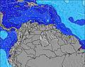 | 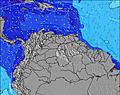 |  | 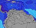 | 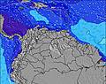 | ||||||||||||
Oleaje Altura (m) Dirección Período (s) | NE 10 | NE 8 | NE 8 | NE 8 | NE 10 | NNE 9 | NNE 9 | NE 9 | E 7 | E 8 | E 8 | E 8 | N 7 | N 7 | N 7 | N 7 | N 7 | N 6 | N 6 |
Gráfico Olas | |||||||||||||||||||
4 | 17 | 21 | 21 | 15 | 8 | 8 | 12 | 0 | 0 | 0 | 0 | 1 | 1 | 1 | 1 | 1 | 1 | 1 | |
Viento (km/h) | |||||||||||||||||||
Estado del Viento Viento de Mar Viento de Mar-Cruzado Cruzado Viento de Tierra-Cruzado Viento de Tierra Cristalino | cross-off | cross-off | cross-off | cross-off | cross-off | cross-off | cross-off | cross-off | cross-off | cross-off | cross-off | cross-off | cross-off | cross-off | cross-off | cross-off | cross-off | cross-off | cross-off |
Marea alta | 8:40PM0.35m | 9:10PM0.36m | 6:22AM0.22m | 9:38PM0.36m | |||||||||||||||
Marea baja | 12:59PM0.05m | 4:03AM0.22m | 1:42PM0.08m | ||||||||||||||||
— | — | — | — | 5:48 | — | — | — | — | — | — | — | 5:50 | — | — | — | — | — | — | |
6:47 | — | — | — | — | — | — | — | 6:47 | — | — | — | — | — | — | — | 6:46 | — | — | |
mm | — | 1 | 1 | — | — | — | — | — | — | — | — | — | — | — | — | — | — | — | — |
Temp. °C | 28 | 27 | 27 | 27 | 27 | 27 | 27 | 27 | 27 | 27 | 27 | 27 | 27 | 27 | 28 | 28 | 27 | 27 | 27 |
Enfriamiento °C | 29 | 27 | 27 | 27 | 27 | 26 | 25 | 25 | 26 | 26 | 26 | 26 | 25 | 26 | 27 | 28 | 26 | 26 | 25 |
Oleaje 1 Altura (m) Dirección Período (s) | ESE 9 | NE 8 | NE 8 | NE 8 | NE 10 | NNE 9 | NNE 9 | NE 9 | — | — | — | — | N 7 | N 7 | N 7 | N 7 | N 7 | N 6 | N 6 |
8 | 17 | 21 | 21 | 15 | 8 | 8 | 12 | — | — | — | — | 1 | 1 | 1 | 1 | 1 | 1 | 1 | |
Oleaje 2 Altura (m) Dirección Período (s) | NE 10 | NE 10 | NE 10 | NE 10 | — | — | — | — | — | — | — | — | — | — | — | — | — | — | — |
4 | 4 | 4 | 4 | — | — | — | — | — | — | — | — | — | — | — | — | — | — | — | |
Oleaje 3 Altura (m) Dirección Período (s) | — | — | — | — | — | — | — | — | — | — | — | — | — | — | — | — | — | — | — |
— | — | — | — | — | — | — | — | — | — | — | — | — | — | — | — | — | — | — | |
Olas de Viento Altura (m) Dirección Período (s) | E 6 | E 6 | E 5 | E 5 | E 6 | E 6 | E 6 | E 7 | E 7 | E 8 | E 8 | E 8 | E 8 | E 8 | E 8 | E 8 | E 8 | E 8 | E 8 |
91 | 80 | 82 | 93 | 148 | 186 | 232 | 320 | 349 | 367 | 377 | 408 | 454 | 454 | 454 | 418 | 422 | 422 | 383 | |
Viento del Tierra o Mar Limpio más proximo | |||||||||||||||||||
Distancia (km) | 1557 | 927 | 415 | 330 | 330 | 415 | 750 | 298 | 925 | 428 | 750 | 372 | 298 | 298 | 298 | 298 | 438 | 925 | 750 |
Mejores Olas Previstas en Netherlands-Antilles - Saint Martin | |||||||||||||||||||
Mejores Olas Previstas en Netherlands Antilles | |||||||||||||||||||
Busca-Olas Global | |||||||||||||||||||
- Map Icons:
 Break
Break Live Wave Height (m)
 Live Wind Speed (km/h)
 Surf Rating (10 Max)
 Ocean Swells (m)
- Wind Speed (km/h)
GRÁTIS! Un widget de Surf-Forecast.com para tu sitio
Este widget grátis de previsiones de surf y tiempo puede ser añadido a cualquier otro sitio y da un resumen de previsiones de olas para Cupecoy. Solo necesita cortar y pegar el código HTML de abajo en su web. Puede elegir preferencias de idioma y de unidades (métricas o imperiales) para convenir a los usuarios de su sitio. Clica aquí para obtener el código.
 Nearest