

Crystal Pier and Pacific Beach Surf Guide
Crystal Pier and Pacific Beach in San Diego County is an exposed beach break that usually has waves. Summer offers the favoured conditions for surfing. The best wind direction is from the northeast. Groundswells are more common than windswells and the ideal swell angle is from the southwest. The beach break provides left and right handers. Best around mid tide when the tide is falling. It's often crowded here. Rocks are a hazard.
Crystal Pier and Pacific Beach Spot Info
| Type: | Rating: | Reliability: | Todays Sea Temp*: |
|---|---|---|---|
| consistent | 23.7°C*ocean temperature recorded from satellite |
Surfing Crystal Pier and Pacific Beach:
The best conditions reported for surf at Crystal Pier and Pacific Beach occur when a Southwest swell combines with an offshore wind direction from the Northeast.

Energía de Olas (poder): 12 horas


Crystal Pier and Pacific Beach Surf:
Thursday, 30 July 2026, 06:23 Local time| jueves 30 | ||||
| 2AM | 5AM | 8AM | 11AM | |
| Wave (m) | ||||
| Período (s) | 16 | 15 | 15 | 15 |
| Viento (km/h) | ||||
| Estado del Viento | glass | glass | cross | cross- on |
- /breaks/Crystal-Pier-and-Pacific-Beach/forecasts/latest
Crystal Pier and Pacific Beach Surf Guide
Crystal Pier and Pacific Beach in San Diego County is an exposed beach break that usually has waves. Summer offers the favoured conditions for surfing. The best wind direction is from the northeast. Groundswells are more common than windswells and the ideal swell angle is from the southwest. The beach break provides left and right handers. Best around mid tide when the tide is falling. It's often crowded here. Rocks are a hazard.
Crystal Pier and Pacific Beach Spot Info
Type: Rating: Reliability: Todays Sea Temp*:  Beach
Beach 3
3consistent 23.7°C*ocean temperature recorded from satelliteSurfing Crystal Pier and Pacific Beach:
The best conditions reported for surf at Crystal Pier and Pacific Beach occur when a Southwest swell combines with an offshore wind direction from the Northeast.
Energía de Olas (poder): 12 horas
Usa la barra de navegación de arriba para ver la temperatura del mar en Crystal Pier and Pacific Beach, fotografías Crystal Pier and Pacific Beach, previsiones detalladas de olas para Crystal Pier and Pacific Beach, vientos y previsión del tiempo, webcams para Crystal Pier and Pacific Beach, viento actual desde estaciones meteorológicas en CAL - San Diego County y predicciones de marea para Crystal Pier and Pacific Beach. Las mapas de olas para United States enseñarán un mapa grande de United States y los mares que rodean. Los mapas de olas pueden ser animadas para mostrar diferentes componentes de olas, la altura de ola, la energía de ola, el período, junto con previsiones de viento y del tiempo. Previsiones actuales del tiempo y del estado del mar provienen de boyas marinas de United States, del barcos que transitan en la zona y de estaciones meteorológicas costeras. Cada página de previsiones tiene un Busca-Olas Regional y Global para localizar las mejores condiciones para surfear en el área de Crystal Pier and Pacific Beach.
Crystal Pier and Pacific Beach Surf:
Thursday, 30 July 2026, 06:23 Local timejueves 30 2AM 5AM 8AM 11AM Wave (m) Período (s) 16 15 15 15 Viento (km/h) Estado del Viento glass glass cross cross-
on- /breaks/Crystal-Pier-and-Pacific-Beach/forecasts/latest
- /breaks/Crystal-Pier-and-Pacific-Beach/forecasts/latest/six_day
Crystal Pier and Pacific Beach Surf Guide
Crystal Pier and Pacific Beach in San Diego County is an exposed beach break that usually has waves. Summer offers the favoured conditions for surfing. The best wind direction is from the northeast. Groundswells are more common than windswells and the ideal swell angle is from the southwest. The beach break provides left and right handers. Best around mid tide when the tide is falling. It's often crowded here. Rocks are a hazard.
Crystal Pier and Pacific Beach Spot Info
Type: Rating: Reliability: Todays Sea Temp*: Beach3consistent 23.7°C*ocean temperature recorded from satelliteSurfing Crystal Pier and Pacific Beach:
The best conditions reported for surf at Crystal Pier and Pacific Beach occur when a Southwest swell combines with an offshore wind direction from the Northeast.
Energía de Olas (poder): 12 horas
Usa la barra de navegación de arriba para ver la temperatura del mar en Crystal Pier and Pacific Beach, fotografías Crystal Pier and Pacific Beach, previsiones detalladas de olas para Crystal Pier and Pacific Beach, vientos y previsión del tiempo, webcams para Crystal Pier and Pacific Beach, viento actual desde estaciones meteorológicas en CAL - San Diego County y predicciones de marea para Crystal Pier and Pacific Beach. Las mapas de olas para United States enseñarán un mapa grande de United States y los mares que rodean. Los mapas de olas pueden ser animadas para mostrar diferentes componentes de olas, la altura de ola, la energía de ola, el período, junto con previsiones de viento y del tiempo. Previsiones actuales del tiempo y del estado del mar provienen de boyas marinas de United States, del barcos que transitan en la zona y de estaciones meteorológicas costeras. Cada página de previsiones tiene un Busca-Olas Regional y Global para localizar las mejores condiciones para surfear en el área de Crystal Pier and Pacific Beach.
Crystal Pier and Pacific Beach Surf:
Thursday, 30 July 2026, 06:23 Local timejueves 30 2AM 5AM 8AM 11AM Wave (m) Período (s) 16 15 15 15 Viento (km/h) Estado del Viento glass glass cross cross-
on- /breaks/Crystal-Pier-and-Pacific-Beach/forecasts/latest
Crystal Pier and Pacific Beach Surf Guide
Crystal Pier and Pacific Beach in San Diego County is an exposed beach break that usually has waves. Summer offers the favoured conditions for surfing. The best wind direction is from the northeast. Groundswells are more common than windswells and the ideal swell angle is from the southwest. The beach break provides left and right handers. Best around mid tide when the tide is falling. It's often crowded here. Rocks are a hazard.
Crystal Pier and Pacific Beach Spot Info
Type: Rating: Reliability: Todays Sea Temp*: Beach3consistent 23.7°C*ocean temperature recorded from satelliteSurfing Crystal Pier and Pacific Beach:
The best conditions reported for surf at Crystal Pier and Pacific Beach occur when a Southwest swell combines with an offshore wind direction from the Northeast.
Energía de Olas (poder): 12 horas
Usa la barra de navegación de arriba para ver la temperatura del mar en Crystal Pier and Pacific Beach, fotografías Crystal Pier and Pacific Beach, previsiones detalladas de olas para Crystal Pier and Pacific Beach, vientos y previsión del tiempo, webcams para Crystal Pier and Pacific Beach, viento actual desde estaciones meteorológicas en CAL - San Diego County y predicciones de marea para Crystal Pier and Pacific Beach. Las mapas de olas para United States enseñarán un mapa grande de United States y los mares que rodean. Los mapas de olas pueden ser animadas para mostrar diferentes componentes de olas, la altura de ola, la energía de ola, el período, junto con previsiones de viento y del tiempo. Previsiones actuales del tiempo y del estado del mar provienen de boyas marinas de United States, del barcos que transitan en la zona y de estaciones meteorológicas costeras. Cada página de previsiones tiene un Busca-Olas Regional y Global para localizar las mejores condiciones para surfear en el área de Crystal Pier and Pacific Beach.
Crystal Pier and Pacific Beach Surf:
Thursday, 30 July 2026, 06:23 Local timejueves 30 2AM 5AM 8AM 11AM Wave (m) Período (s) 16 15 15 15 Viento (km/h) Estado del Viento glass glass cross cross-
onTide Times:
Para Crown Point, Mission Bay, California, a %{dist} %{km} de %{location}.
PROXIMA ES A LAS (hora local) quedan marea alta marea baja Crystal Pier and Pacific Beach Tide Times and Tide Chart
Live Weather:
At La Jolla- CA, 8 km from Crystal Pier and Pacific Beach.
calm
(km/h)Air temperature
-°CCurrent weather near Crystal Pier and Pacific Beach
Buoy Data:
At SCRIPPS Nearshore, CA, 5 miles from Crystal Pier and Pacific Beach.
12AM 1AM 2AM 3AM Antigüedad de datos 5 hr 4 hr 3 hr 2 hr Altura de Olas (m) 

Período Dominante (s) 8 8 9 8 Overall Crystal Pier and Pacific Beach Surf Consistency and Wind Distribution in julio
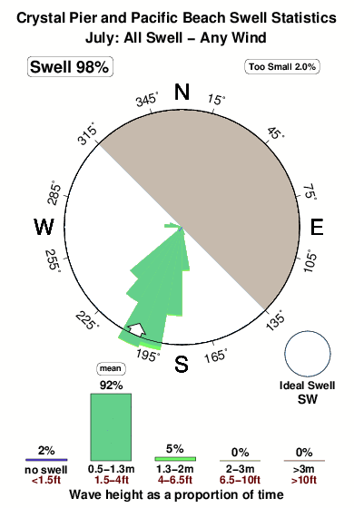


Surf stats for Crystal Pier and Pacific Beach: see the swell variation by month.
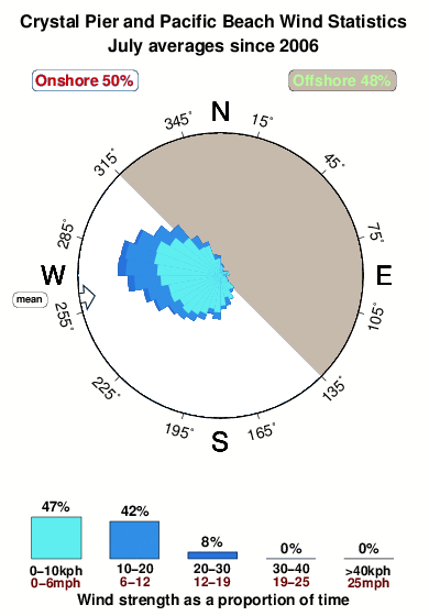
Wind stats for Crystal Pier and Pacific Beach: see the variation in direction and stength by month.
Fotos de Surf
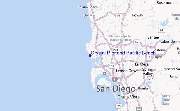
de la galeríaContornos: Carreteras y Ríos: Selecciona un spot desde el menú 


Usa este mapa para navegar hacia las playas de surf de CAL - San Diego County y estaciones de marea cercanas de Crystal Pier and Pacific Beach
Spots de Surf más cercanos a Crystal Pier and Pacific Beach:
(Clica la ubicación para más detalles)- Closest spot0 mi
- Second closest spot0 mi
- Third closest spot1 mi
- Fourth closest spot1 mi
- Fifth closest spot1 mi
Boyas marinas más cercanas a Crystal Pier and Pacific Beach:
- Closest Boya Marinas5 mi
- Second closest Boya Marinas5 mi
- Third closest Boya Marinas12 mi
- Fourth closest Boya Marinas14 mi
- Fifth closest Boya Marinas17 mi
Estaciones de marea más cercanas a Crystal Pier and Pacific Beach:
- Closest estación de mareaCrown Point, Mission Bay2 mi
- Second closest estación de mareaQuivira Basin, Mission Bay3 mi
- Third closest estación de mareaLa Jolla, Scripps Pier4 mi
- Fourth closest estación de mareaSan Diego, Quarantine Station7 mi
- Fifth closest estación de mareaSan Diego8 mi
Airports
- The closest passenger airport to Crystal Pier and Pacific Beach is San Diego International Lindbergh Fld Airport (SAN) in USA, 10 km (6 miles) away (directly).
- The second nearest airport to Crystal Pier and Pacific Beach is North Island Nas (San Diego) Airport (NZY), also in USA, 12 km (7 miles) away.
- Third is Miramar Mcas Airport (NKX) in USA, 13 km (8 miles) away.
- General Abelardo L Rodriguez International (Tijuana) Airport (TIJ) in Mexico is 40 km (25 miles) away.
- John Wayne Arpt Orange Co (Santa Ana) Airport (SNA) in USA is the fifth nearest airport to Crystal Pier and Pacific Beach and is 112 km (70 miles) away.

- /breaks/Crystal-Pier-and-Pacific-Beach/forecasts/latest


 Nearest