

Crash Boat Surf Guide
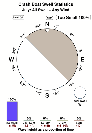
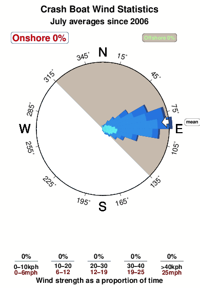
Crash Boat in Atlantic is a sheltered beach and reef break that does not work very often. Summer in particular tends to be flat. Ideal winds are from the northeast. Groundswells and windswells are equally likely A reef breaks right. Good surf at all stages of the tide. Sometimes crowded. Beware of urchins, rips and rocks.
Crash Boat Spot Info
| Type: | Rating: | Reliability: | Todays Sea Temp*: |
|---|---|---|---|
| inconsistent | 28.8°C*ocean temperature recorded from satellite |
Surfing Crash Boat:
The best conditions reported for surf at Crash Boat occur when a West swell combines with an offshore wind direction from the Northeast.

Energía de Olas (poder): 12 horas


Crash Boat Surf:
Wednesday, 29 July 2026, 01:05 Local time| mar | miércoles 29 | |||
| 11PM | 2AM | 5AM | 8AM | |
| Wave (m) | ||||
| Período (s) | - | - | - | - |
| Viento (km/h) | ||||
| Estado del Viento | cross | cross- off |
cross- off |
cross- off |
- /breaks/Crash-Boat/forecasts/latest
Crash Boat Surf Guide
Crash Boat in Atlantic is a sheltered beach and reef break that does not work very often. Summer in particular tends to be flat. Ideal winds are from the northeast. Groundswells and windswells are equally likely A reef breaks right. Good surf at all stages of the tide. Sometimes crowded. Beware of urchins, rips and rocks.
Crash Boat Spot Info
Type: Rating: Reliability: Todays Sea Temp*:  Beach and reef
 4
4inconsistent 28.8°C*ocean temperature recorded from satelliteSurfing Crash Boat:
The best conditions reported for surf at Crash Boat occur when a West swell combines with an offshore wind direction from the Northeast.
Energía de Olas (poder): 12 horas
Usa la barra de navegación de arriba para ver la temperatura del mar en Crash Boat, fotografías Crash Boat, previsiones detalladas de olas para Crash Boat, vientos y previsión del tiempo, webcams para Crash Boat, viento actual desde estaciones meteorológicas en Puerto Rico y predicciones de marea para Crash Boat. Las mapas de olas para Puerto Rico enseñarán un mapa grande de Puerto Rico y los mares que rodean. Los mapas de olas pueden ser animadas para mostrar diferentes componentes de olas, la altura de ola, la energía de ola, el período, junto con previsiones de viento y del tiempo. Previsiones actuales del tiempo y del estado del mar provienen de boyas marinas de Puerto Rico, del barcos que transitan en la zona y de estaciones meteorológicas costeras. Cada página de previsiones tiene un Busca-Olas Regional y Global para localizar las mejores condiciones para surfear en el área de Crash Boat.
Crash Boat Surf:
Wednesday, 29 July 2026, 01:05 Local timemar miércoles 29 11PM 2AM 5AM 8AM Wave (m) Período (s) - - - - Viento (km/h) Estado del Viento cross cross-
offcross-
offcross-
off- /breaks/Crash-Boat/forecasts/latest
- /breaks/Crash-Boat/forecasts/latest/six_day
Crash Boat Surf Guide
Crash Boat in Atlantic is a sheltered beach and reef break that does not work very often. Summer in particular tends to be flat. Ideal winds are from the northeast. Groundswells and windswells are equally likely A reef breaks right. Good surf at all stages of the tide. Sometimes crowded. Beware of urchins, rips and rocks.
Crash Boat Spot Info
Type: Rating: Reliability: Todays Sea Temp*: Beach and reef4inconsistent 28.8°C*ocean temperature recorded from satelliteSurfing Crash Boat:
The best conditions reported for surf at Crash Boat occur when a West swell combines with an offshore wind direction from the Northeast.
Energía de Olas (poder): 12 horas
Usa la barra de navegación de arriba para ver la temperatura del mar en Crash Boat, fotografías Crash Boat, previsiones detalladas de olas para Crash Boat, vientos y previsión del tiempo, webcams para Crash Boat, viento actual desde estaciones meteorológicas en Puerto Rico y predicciones de marea para Crash Boat. Las mapas de olas para Puerto Rico enseñarán un mapa grande de Puerto Rico y los mares que rodean. Los mapas de olas pueden ser animadas para mostrar diferentes componentes de olas, la altura de ola, la energía de ola, el período, junto con previsiones de viento y del tiempo. Previsiones actuales del tiempo y del estado del mar provienen de boyas marinas de Puerto Rico, del barcos que transitan en la zona y de estaciones meteorológicas costeras. Cada página de previsiones tiene un Busca-Olas Regional y Global para localizar las mejores condiciones para surfear en el área de Crash Boat.
Crash Boat Surf:
Wednesday, 29 July 2026, 01:05 Local timemar miércoles 29 11PM 2AM 5AM 8AM Wave (m) Período (s) - - - - Viento (km/h) Estado del Viento cross cross-
offcross-
offcross-
off- /breaks/Crash-Boat/forecasts/latest
Crash Boat Surf Guide
Crash Boat in Atlantic is a sheltered beach and reef break that does not work very often. Summer in particular tends to be flat. Ideal winds are from the northeast. Groundswells and windswells are equally likely A reef breaks right. Good surf at all stages of the tide. Sometimes crowded. Beware of urchins, rips and rocks.
Crash Boat Spot Info
Type: Rating: Reliability: Todays Sea Temp*: Beach and reef4inconsistent 28.8°C*ocean temperature recorded from satelliteSurfing Crash Boat:
The best conditions reported for surf at Crash Boat occur when a West swell combines with an offshore wind direction from the Northeast.
Energía de Olas (poder): 12 horas
Usa la barra de navegación de arriba para ver la temperatura del mar en Crash Boat, fotografías Crash Boat, previsiones detalladas de olas para Crash Boat, vientos y previsión del tiempo, webcams para Crash Boat, viento actual desde estaciones meteorológicas en Puerto Rico y predicciones de marea para Crash Boat. Las mapas de olas para Puerto Rico enseñarán un mapa grande de Puerto Rico y los mares que rodean. Los mapas de olas pueden ser animadas para mostrar diferentes componentes de olas, la altura de ola, la energía de ola, el período, junto con previsiones de viento y del tiempo. Previsiones actuales del tiempo y del estado del mar provienen de boyas marinas de Puerto Rico, del barcos que transitan en la zona y de estaciones meteorológicas costeras. Cada página de previsiones tiene un Busca-Olas Regional y Global para localizar las mejores condiciones para surfear en el área de Crash Boat.
Crash Boat Surf:
Wednesday, 29 July 2026, 01:05 Local timemar miércoles 29 11PM 2AM 5AM 8AM Wave (m) Período (s) - - - - Viento (km/h) Estado del Viento cross cross-
offcross-
offcross-
offTide Times:
Para Aguadilla, Crashboat Beach, Puerto Rico, a %{dist} %{km} de %{location}.
PROXIMA ES A LAS (hora local) quedan marea alta marea baja Crash Boat Tide Times and Tide Chart
Live Weather:
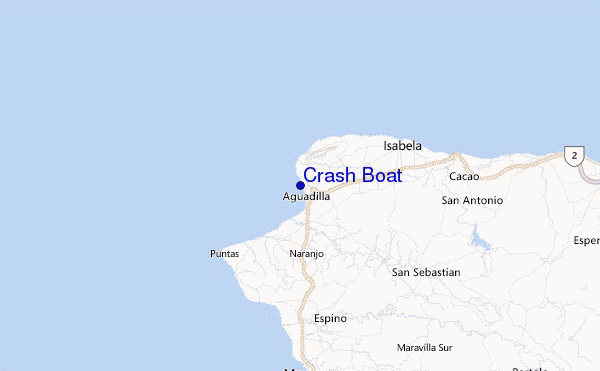
At Aguadilla/Rafael Hernández Airport, 7 km from Crash Boat.
calm
(km/h)
ClearAir temperature
26°CCurrent weather near Crash Boat
Buoy Data:
At Rincon Buoy , Puerto Rico, 9 miles from Crash Boat.
8PM 9PM 10PM 11PM Antigüedad de datos 4 hr 3 hr 2 hr 1 hr Altura de Olas (m) 


Período Dominante (s) 6 6 5 6 Overall Crash Boat Surf Consistency and Wind Distribution in julio
Fotos de Surf
de la galeríaContornos: Carreteras y Ríos: Selecciona un spot desde el menú 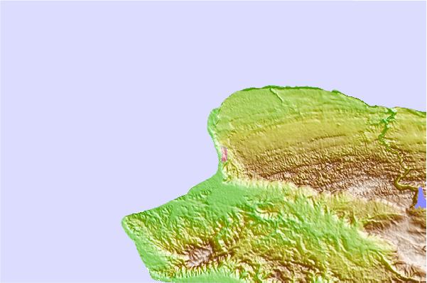


Usa este mapa para navegar hacia las playas de surf de Puerto Rico y estaciones de marea cercanas de Crash Boat
Spots de Surf más cercanos a Crash Boat:
(Clica la ubicación para más detalles)- Closest spot1 mi
- Second closest spot2 mi
- Third closest spot2 mi
- Fourth closest spot4 mi
- Fifth closest spot4 mi
Boyas marinas más cercanas a Crash Boat:
- Closest Boya Marinas9 mi
- Second closest Boya Marinas58 mi
- Third closest Boya Marinas70 mi
- Fourth closest Boya Marinas112 mi
- Fifth closest Boya Marinas158 mi
Estaciones de marea más cercanas a Crash Boat:
- Closest estación de mareaAguadilla, Crashboat Beach1 mi
- Second closest estación de mareaIsabela10 mi
- Third closest estación de mareaQuebradillas15 mi
- Fourth closest estación de mareaMayaguez (sub)16 mi
- Fifth closest estación de mareaMayaguez16 mi
Airports
- The closest passenger airport to Crash Boat is Rafael Hernandez (Aguadilla) Airport (BQN) in Puerto Rico, 6 km (4 miles) away (directly).
- The second nearest airport to Crash Boat is Eugenio Maria De Hostos (Mayaguez) Airport (MAZ), also in Puerto Rico, 22 km (14 miles) away.
- Third is Mercedita (Ponce) Airport (PSE) in Puerto Rico, 80 km (50 miles) away.
- Fernando Luis Ribas Dominicci (San Juan) Airport (SIG) in Puerto Rico is 112 km (70 miles) away.
- Luis Munoz Marin International (San Juan) Airport (SJU), also in Puerto Rico is the fifth nearest airport to Crash Boat and is 123 km (76 miles) away.

- /breaks/Crash-Boat/forecasts/latest


 Nearest