
Previsiones:

Pronóstico Corto PlazoMayormente seco. Very mild (max 14°C el viernes por la tarde, min 11°C el jueves por la mañana). El viento será generalmente ligero. | ||||||||||||||||||
mié 29 | jueves 30 | viernes 31 | ||||||||||||||||
6 PM | 9 PM | 12 AM | 3 AM | 6 AM | 9 AM | 12 PM | 3 PM | 6 PM | 9 PM | 12 AM | 3 AM | 6 AM | 9 AM | 12 PM | 3 PM | 6 PM | 9 PM | |
Mapa de Altura de Olas |  | 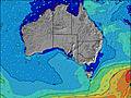 | 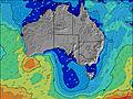 | 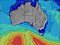 | 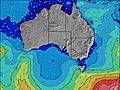 | 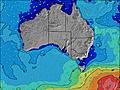 | 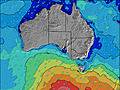 | |||||||||||
Oleaje Altura (m) Dirección Período (s) | SW 14 | SW 14 | SSW 13 | SSW 13 | SSW 13 | SSW 13 | SW 13 | SW 13 | SW 13 | SW 13 | SW 13 | SW 13 | SW 13 | SW 13 | SW 13 | SW 13 | SW 13 | SSW 13 |
Gráfico Olas | ||||||||||||||||||
5140 | 4214 | 3584 | 3010 | 2737 | 2288 | 1723 | 1518 | 1305 | 1204 | 1129 | 1044 | 951 | 851 | 803 | 828 | 841 | 796 | |
Viento (km/h) | ||||||||||||||||||
Estado del Viento Viento de Mar Viento de Mar-Cruzado Cruzado Viento de Tierra-Cruzado Viento de Tierra Cristalino | on | cross-on | on | on | on | on | on | on | on | glassy | glassy | glassy | off | off | off | off | off | off |
Marea alta | 00:48AM0.56m | 12:56PM1.14m | 1:08AM0.61m | 1:20PM1.13m | ||||||||||||||
Marea baja | 7:54PM0.30m | 5:44AM0.31m | 8:04PM0.30m | 6:20AM0.29m | 8:14PM0.31m | |||||||||||||
— | — | — | — | 7:20 | — | — | — | — | — | — | — | 7:18 | — | — | — | — | — | |
— | — | — | — | — | — | — | 5:35 | — | — | — | — | — | — | — | 5:36 | — | — | |
mm | — | — | — | — | — | — | — | — | — | — | — | — | — | — | — | — | — | — |
Temp. °C | 12 | 12 | 12 | 12 | 12 | 11 | 11 | 12 | 12 | 12 | 12 | 12 | 13 | 13 | 13 | 14 | 12 | 12 |
Enfriamiento °C | 8 | 9 | 9 | 9 | 9 | 9 | 8 | 10 | 10 | 10 | 10 | 10 | 10 | 10 | 9 | 10 | 8 | 8 |
Oleaje 1 Altura (m) Dirección Período (s) | SW 14 | SW 14 | SSW 13 | SSW 13 | SSW 13 | SSW 13 | SW 13 | SW 13 | SW 13 | SW 13 | SW 13 | SW 13 | SW 13 | SW 13 | SW 13 | SW 13 | SW 13 | SSW 13 |
5140 | 4214 | 3584 | 3010 | 2737 | 2288 | 1723 | 1518 | 1305 | 1204 | 1129 | 1044 | 951 | 851 | 803 | 828 | 841 | 796 | |
Oleaje 2 Altura (m) Dirección Período (s) | — | — | — | — | SSE 8 | SSE 10 | S 10 | S 10 | S 9 | S 9 | SSE 9 | SSE 9 | S 9 | S 8 | SW 20 | SW 19 | SW 19 | SW 18 |
— | — | — | — | 246 | 342 | 183 | 148 | 136 | 106 | 84 | 64 | 56 | 35 | 552 | 546 | 384 | 628 | |
Oleaje 3 Altura (m) Dirección Período (s) | — | — | — | — | — | — | — | SW 24 | SW 24 | SW 23 | SSW 22 | SW 21 | SW 21 | SW 20 | S 8 | SSE 8 | SSE 8 | SE 8 |
— | — | — | — | — | — | — | 22 | 22 | 21 | 46 | 117 | 117 | 206 | 35 | 22 | 13 | 30 | |
Olas de Viento Altura (m) Dirección Período (s) | — | — | — | — | — | — | — | — | — | — | — | — | — | — | — | — | — | — |
— | — | — | — | — | — | — | — | — | — | — | — | — | — | — | — | — | — | |
Viento del Tierra o Mar Limpio más proximo | ||||||||||||||||||
Distancia (km) | 45 | 45 | 45 | 45 | 45 | 5 | 45 | 45 | 24 | 5 | 5 | 5 | 5 | 5 | 5 | 5 | 5 | 5 |
Mejores Olas Previstas en Kangaroo Island | ||||||||||||||||||
Mejores Olas Previstas en Australia | ||||||||||||||||||
Busca-Olas Global | ||||||||||||||||||
- Map Icons:
 Break
Break Live Wave Height (m)
 Live Wind Speed (km/h)
 Surf Rating (10 Max)
 Ocean Swells (m)
- Wind Speed (km/h)
GRÁTIS! Un widget de Surf-Forecast.com para tu sitio
Este widget grátis de previsiones de surf y tiempo puede ser añadido a cualquier otro sitio y da un resumen de previsiones de olas para Cape Kersaint. Solo necesita cortar y pegar el código HTML de abajo en su web. Puede elegir preferencias de idioma y de unidades (métricas o imperiales) para convenir a los usuarios de su sitio. Clica aquí para obtener el código.
 Nearest