- Forecast
- Maps
- Live
- Weather State
- Spot Information
Boners Previsión de Olas
/ CAL – San Luis Obispo (23 breaks) / California (404 breaks) /Previsiones:

Surf en BonersPronóstico / CAL – San Luis Obispo / USA
Actualizacion del pronostico en hora min s Forecast update imminent
La altura de oleaje para Boners es en mar abierto. Olas rompiendo en la orilla/arrecife son usualmente más pequeñas en áreas protegidas.
La temperatura del mar en Boners hoy es
14.1° C
(Lo cual es 1.4°C más frío que el promedio para esta época del año)Actualizaciones en hora min s Forecast update imminent
jue 30 | viernes 31 | sábado 01 | domingo 02 | |||||||||||||||||||||
| 8 PM | 11 PM | 2 AM | 5 AM | 8 AM | 11 AM | 2 PM | 5 PM | 8 PM | 11 PM | 2 AM | 5 AM | 8 AM | 11 AM | 2 PM | 5 PM | 8 PM | 11 PM | 2 AM | 5 AM | 8 AM | 11 AM | 2 PM | 5 PM | |
Notación (10 max) | ||||||||||||||||||||||||
Mapa de Altura de Olas |  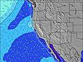 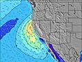 |  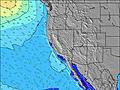 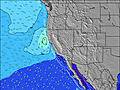 |  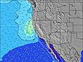 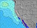 |  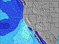 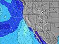 | ||||||||||||||||||||
| Altura de Olas (m) & dirección (?) | ||||||||||||||||||||||||
| Período(s) (?) | 8 | 8 | 22 | 8 | 8 | 11 | 21 | 20 | 20 | 20 | 20 | 19 | 18 | 18 | 21 | 19 | 18 | 17 | 16 | 16 | 16 | 16 | 16 | 15 |
Gráfico (?)Olas | ||||||||||||||||||||||||
| 443 | 919 | 682 | 476 | 515 | 980 | 483 | 495 | 603 | 544 | 432 | 428 | 531 | 497 | 634 | 1255 | 1553 | 3229 | 3636 | 3378 | 3113 | 2716 | 2647 | 2235 | |
Viento (km/h) | ||||||||||||||||||||||||
| Estado del Viento (?) onshore Viento de Mar-Cruzado Cruzado Viento de Tierra-Cruzado Viento de Tierra Cristalino | cross | cross- off | cross- off | cross- off | cross- off | cross | cross | cross | cross- off | cross- off | cross- off | cross- off | cross- off | glass | cross | cross | cross- off | glass | off | off | off | cross- on | cross | cross |
Marea alta / altura (m) | 5:23PM 1.32 | 7:33AM 1.35 | 6:34PM 1.34 | 7:53AM 1.48 | 7:37PM 1.36 | 8:17AM 1.64 | ||||||||||||||||||
Marea baja / altura (m) | 12:36AM 0.15 | 1:09PM 0.76 | 1:14AM 0.17 | 1:55PM 0.53 | 1:49AM 0.23 | 2:40PM 0.28 | ||||||||||||||||||
jue 30 | viernes 31 | sábado 01 | domingo 02 | |||||||||||||||||||||
| Amanecer | - | - | - | - | 7:24 | - | - | - | - | - | - | - | 7:26 | - | - | - | - | - | - | - | 7:26 | - | - | - |
| Puesta del Sol | - | - | - | - | - | - | - | 6:09 | - | - | - | - | - | - | - | 6:08 | - | - | - | - | - | - | - | 6:07 |
Lluvia (mm) | - | - | - | - | - | - | - | - | - | - | - | - | - | - | - | - | - | - | - | - | - | - | - | - |
| Temp. °C | 16 | 16 | 16 | 16 | 16 | 20 | 21 | 20 | 19 | 20 | 19 | 18 | 18 | 23 | 24 | 22 | 22 | 20 | 20 | 19 | 19 | 22 | 23 | 22 |
| Feels °C (?) | 13 | 14 | 14 | 14 | 15 | 19 | 19 | 18 | 18 | 19 | 18 | 17 | 17 | 22 | 22 | 19 | 20 | 19 | 18 | 17 | 17 | 20 | 21 | 21 |
- Map Icons:
 Break
Break Live Wave Height (m)
 Live Wind Speed (km/h)
 Surf Rating (10 Max)
 Ocean Swells (m)
- Wind Speed (km/h)
GRÁTIS! Un widget de Surf-Forecast.com para tu sitio
Este widget grátis de previsiones de surf y tiempo puede ser añadido a cualquier otro sitio y da un resumen de previsiones de olas para Boners. Solo necesita cortar y pegar el código HTML de abajo en su web. Puede elegir preferencias de idioma y de unidades (métricas o imperiales) para convenir a los usuarios de su sitio. Clica aquí para obtener el código.
 Nearest