

Rio Grande Do Sul Surf
Detailed Rio Grande Do Sul surf forecast maps and the latest eyeball surf report from local surfers in the region. Near-shore swell is shown on the map together with the surf forecast rating for spots in Rio Grande Do Sul. Find the best places to surf in offshore conditions by selecting the wind option on the forecast map. Windsurfers and kite surfers can also use this option to find more favorable cross-shore conditions in Rio Grande Do Sul. Our local Wavefinder indicates where some of the best conditions are likely to be found in Rio Grande Do Sul over the next 7 days. Surf photos from Rio Grande Do Sul and reviews of the best spots and surfing conditions have been provided by local surfers.
Rio Grande Do Sul Surf Forecast
Rio Grande Do Sul Surf Forecast map for predicting the best wave and wind conditions across the region. For surfers, the map shows the most powerful swell tracking across near-shore open water and not the peak waves experienced by boats out at sea. Move your mouse over the ocean swell symbols or the surf breaks on the coastline to see a more detailed surf forecast including wave period and wind conditions. The forecast updates every 6 hours and most live weather reports update every hour. You can animate the Rio Grande Do Sul Surf map or show live wind and wave conditions as reported from wavebuoys and local weather stations. Surf breaks shown along the Rio Grande Do Sul coastline are also listed below.
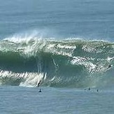
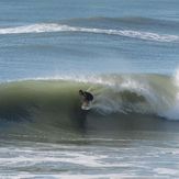
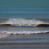
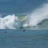
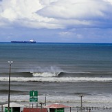
Rio Grande Do Sul Photos
Rio Grande Do Sul Wavefinder
| Thursday 02 | Friday 03 | Saturday 04 | Sunday 05 | Monday 06 | Tuesday 07 | |||||||||||||
AM | PM | Night | AM | PM | Night | AM | PM | Night | AM | PM | Night | AM | PM | Night | AM | PM | Night | |
Best forecast wave conditions in Rio Grande Do Sul |  | |  | |  |  |  | | | |  |  | | | | |  | |
| Rating | ||||||||||||||||||
Wave Height (m) & direction (?) | 0.4 ESE | 0.7 ENE | 0.7 S | 1.4 SSW | 1.0 S | 1.8 ESE | 2.3 ESE | 2.5 ESE | 1.8 ESE | 1.4 ESE | 1.3 ENE | 0.8 E | 0.8 E | 0.4 SE | 1.1 ENE | 1.7 E | 1.7 ESE | 1.6 E |
| Period(s) (?) | 12 | 7 | 12 | 8 | 8 | 7 | 7 | 8 | 8 | 7 | 6 | 8 | 7 | 13 | 7 | 6 | 7 | 7 |
| Energy(?) | 55 | 49 | 132 | 226 | 133 | 273 | 529 | 916 | 384 | 199 | 123 | 71 | 68 | 59 | 128 | 221 | 262 | 276 |
| Wind (km/h) | ||||||||||||||||||
| Wind State(?) | glass | cross- off | cross- off | cross- off | cross- off | glass | cross- off | cross- on | glass | cross- off | cross- off | cross- off | glass | cross- off | cross- off | on | cross- off | off |
High Tide / height (m) | 11:42AM | 12:31AM | 2:50PM 7:30AM | 9:36PM 3:00AM | 9:11AM | 3:37PM | 10:15PM | 4:07AM 10:12AM | 4:51PM 1:53PM | 10:52PM | 3:02AM 11:29AM | 5:35PM | 11:37PM | 4:13AM 11:46AM | 4:19PM | 11:40PM | ||
Low Tide / height (m) | 3:39PM | 9:21AM | 6:10PM 10:57PM | 7:14AM 11:57AM 10:00AM | 7:16PM 12:08AM | 8:04AM | 1:19PM | 8:24PM 1:16AM | 7:09AM 3:49PM | 1:51PM | 7:37PM 1:43AM | 7:37AM | 2:29PM | 8:22PM | ||||
Summary | heavy rain | heavy rain | clear | clear | clear | heavy rain | light rain | light rain | rain shwrs | rain shwrs | some clouds | rain shwrs | heavy rain | mod. rain | some clouds | risk thund- der | risk thund- der | heavy rain |
Rain (mm) | 32 | 27 | - | - | - | 73 | 2 | 1 | 6 | 14 | - | 6 | 37 | 7 | - | 3 | 3 | 13 |
High °C | 21 | 21 | 14 | 15 | 15 | 20 | 21 | 21 | 21 | 21 | 22 | 21 | 20 | 19 | 25 | 19 | 20 | 20 |
Low °C | 21 | 20 | 13 | 13 | 14 | 19 | 20 | 21 | 20 | 20 | 21 | 20 | 19 | 19 | 22 | 19 | 20 | 20 |
Chill °C (?) | 21 | 21 | 13 | 14 | 14 | 20 | 21 | 21 | 21 | 21 | 22 | 21 | 20 | 19 | 25 | 19 | 20 | 20 |
Sunrise | 6:50 | - | - | 7:11 | - | - | 6:50 | - | - | 6:52 | - | - | 7:15 | - | - | 7:15 | - | - |
Sunset | - | 5:43 | - | - | 5:50 | - | - | 5:42 | - | - | 5:47 | - | - | 5:46 | - | - | 5:45 | - |
| Swell1 (m) & direction | 0.7 ENE | 0.7 ENE | 0.7 S | 1.1 S | 1.0 S | 1.8 ESE | 1.5 ESE | 2.2 ESE | 1.8 ESE | 1.4 ESE | 1.0 E | 0.8 E | 0.8 E | 0.9 E | 1.1 ENE | 1.1 SSE | 0.2 SSE | 0.3 SSE |
| Period (s) | 7 | 7 | 12 | 8 | 8 | 7 | 7 | 8 | 8 | 7 | 6 | 8 | 7 | 7 | 7 | 7 | 11 | 12 |
| Swell2 (m) & direction | 0.4 ESE | 0.4 SE | 0.6 E | 0.5 SE | 0.5 SE | 0.8 SE | 1.0 ENE | 0.6 S | 0.6 ESE | 0.6 ESE | 0.4 SSE | 0.4 SE | 0.4 SE | 0.4 SE | 0.3 SE | 0.3 S | 0.2 SSE | 0.1 S |
| Period (s) | 12 | 11 | 7 | 16 | 16 | 14 | 7 | 11 | 13 | 13 | 9 | 13 | 13 | 13 | 12 | 12 | 8 | 18 |
| Wind waves (m) & direction | - | 0.4 SW | 1.0 S | 1.4 SSW | - | 1.4 ENE | 2.3 ESE | 2.5 ESE | - | 0.7 NE | 1.3 ENE | - | 0.4 SSE | - | - | 1.7 E | 1.7 ESE | 1.6 E |
| Period (s) | - | 9 | 6 | 8 | - | 6 | 7 | 8 | - | 7 | 6 | - | 8 | - | - | 6 | 7 | 7 |

Rio Grande Do Sul Surf Breaks
Rio Grande do Sul is the southernmost state in Brazil. Its shoreline is a straight sand beach from north to south with almost no mountains except for a few cliffs on the city of Torres on the north border. It is just a very long beach with a dozen rivermouths along its almost 700km of endless beachbreaks. Because of the location, down south in South America its climate is unique when compared to the rest of Brazil. It can get very cold in winter time and very warm on summer. It usually gets out of control when winter swells roll up the coast coming from the south so it's by the end of spring, then summer and specially in the beginning of autumn that everything fits into place and the chances of scoring good waves with offshore winds increase. The waves in this region are usually mushy with the predominant NE wind, but on those not so rare NW, W or SW days (offshore) it starts looking like mini Puertos - you see perfect barrels everywhere! ..... Giovanni Mancuso
Here in Salinas there are only beach breaks, the best wave here is next to a fishing platform, on both sides it is good to surf. With south winds, it is better in the north side, and with north winds the south side has better waves. Rio Grande do Sul, receives good swells all through the year, but between May and November the winds are best. The scenary is the same in all along the coastline, from Torres to Chuy ..... Tiago Dutra Cardoso


 Nearest