- Forecast
- Maps
- Live
- Weather State
- Spot Information
Peffer Sands Previsión de Olas
/ Scot – East Coast (44 surf breaks) /Previsiones:

Surf en Peffer SandsPronóstico / Scot – East Coast / UK
Actualizacion del pronostico en hora min s Forecast update imminent
La altura de oleaje para Peffer Sands es en mar abierto. Olas rompiendo en la orilla/arrecife son usualmente más pequeñas en áreas protegidas.
La temperatura del mar en Peffer Sands hoy es
11.5° C
(Lo cual es ligeramente más cálido de lo habitual)Actualizaciones en hora min s Forecast update imminent
viernes 14 | sábado 15 | domingo 16 | lunes 17 | |||||||||||||||||||||
| 9 AM | 12 PM | 3 PM | 6 PM | 9 PM | 0 AM | 3 AM | 6 AM | 9 AM | 12 PM | 3 PM | 6 PM | 9 PM | 0 AM | 3 AM | 6 AM | 9 AM | 12 PM | 3 PM | 6 PM | 9 PM | 0 AM | 3 AM | 6 AM | |
Notación (10 max) | ||||||||||||||||||||||||
Mapa de Altura de Olas |    |    |    |  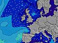 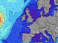 | ||||||||||||||||||||
| Altura de Olas (m) & dirección (?) | ||||||||||||||||||||||||
| Período(s) (?) | 11 | 6 | 11 | 6 | 7 | 7 | 7 | 7 | 7 | 7 | 7 | 7 | 8 | 8 | 7 | 10 | 7 | 7 | 7 | 6 | 7 | 7 | 8 | 10 |
Gráfico (?)Olas | ||||||||||||||||||||||||
| 548 | 163 | 265 | 353 | 480 | 554 | 555 | 563 | 470 | 321 | 264 | 214 | 196 | 143 | 140 | 180 | 83 | 77 | 48 | 56 | 160 | 164 | 344 | 932 | |
Viento (km/h) | ||||||||||||||||||||||||
| Estado del Viento (?) onshore Viento de Mar-Cruzado Cruzado Viento de Tierra-Cruzado Viento de Tierra Cristalino | cross- on | cross- on | cross- on | cross- on | cross- on | cross- on | cross- on | cross- on | cross- on | cross- on | cross- on | cross- on | cross- on | cross- on | on | cross- on | cross- on | cross- off | cross | cross- on | cross- on | cross | cross- on | cross- on |
Marea alta / altura (m) | 10:04AM 3.51 | 10:06PM 3.69 | 11:00AM 3.64 | 11:02PM 3.79 | 11:45AM 3.79 | 11:50PM 3.90 | ||||||||||||||||||
Marea baja / altura (m) | 4:03PM 1.63 | 4:41AM 0.94 | 5:03PM 1.44 | 5:29AM 0.85 | 5:48PM 1.22 | |||||||||||||||||||
viernes 14 | sábado 15 | domingo 16 | lunes 17 | |||||||||||||||||||||
| Amanecer | 7:43 | - | - | - | - | - | - | - | 7:46 | - | - | - | - | - | - | - | 7:48 | - | - | - | - | - | - | - |
| Puesta del Sol | - | - | 4:04 | - | - | - | - | - | - | - | 4:02 | - | - | - | - | - | - | - | 4:00 | - | - | - | - | - |
Lluvia (mm) | - | - | - | - | - | - | - | - | - | - | - | - | - | - | - | - | - | - | - | - | - | - | - | - |
| Temp. °C | 8 | 9 | 9 | 9 | 8 | 8 | 8 | 8 | 8 | 9 | 8 | 8 | 8 | 7 | 7 | 6 | 5 | 6 | 7 | 7 | 6 | 5 | 5 | 4 |
| Feels °C (?) | 0 | 0 | -1 | -1 | -3 | -3 | -2 | -2 | 0 | 2 | 2 | 3 | 3 | 3 | 2 | 1 | 1 | 0 | 1 | 1 | 0 | -2 | -4 | -4 |
- Map Icons:
 Break
Break Live Wave Height (m)
 Live Wind Speed (km/h)
 Surf Rating (10 Max)
 Ocean Swells (m)
- Wind Speed (km/h)
GRÁTIS! Un widget de Surf-Forecast.com para tu sitio
Este widget grátis de previsiones de surf y tiempo puede ser añadido a cualquier otro sitio y da un resumen de previsiones de olas para Peffer Sands. Solo necesita cortar y pegar el código HTML de abajo en su web. Puede elegir preferencias de idioma y de unidades (métricas o imperiales) para convenir a los usuarios de su sitio. Clica aquí para obtener el código.
 Nearest