

- Forecast
- Maps
- Live
- Weather State
- Spot Information
Mullaloo Surf Forecast
/ WA – Perth City (29 breaks) / Western Australia (159 breaks) /
Surf Forecasts

Point
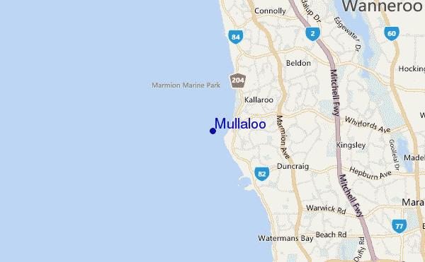
Mullaloo surf Forecast / WA – Perth City / Australia
48hr Weather and Surf, issued 1 am Wednesday 24 Apr 2024 AWST
Forecast update in hr min s Update imminent
Mullaloo surf forecast is for near shore open water. Breaking waves will often be smaller at less exposed spots.
Today's Mullaloo sea temperature is 22.3°C (Statistics for 24 Apr 1981-2005 - mean: 22.2 °C max: 24.7 °C min: 20.3 °C)
- Map Icons:
 Break
Break Live Wave Height (m)
 Live Wind Speed (km/h)
 Surf Rating (10 Max)
 Ocean Swells (m)
- Wind Speed (km/h)
Mullaloo surf forecast is for near shore open water. Breaking waves will often be smaller at less exposed spots.
Today's Mullaloo sea temperature is 22.3°C (Statistics for 24 Apr 1981-2005 - mean: 22.2 °C max: 24.7 °C min: 20.3 °C)
How big are the waves at Mullaloo today?
The current surf forecast for Mullaloo at 3AM is: 1.3m 13s primary swell from a West-southwest direction (forecast issued at 01:00am April 24). An open ocean swell of 0.9m 4s is not directed at the surf break. The wind direction is predicted to be cross-offshore and the swell rating is 2.
| Time (AWST) & Date | Wave Height | Wave Period |
|---|---|---|
| Morning (24 Apr) | 4ft (1.2m) | 13s |
| Afternoon (24 Apr) | 3.5ft (1.1m) | 12s |
| Evening (24 Apr) | 3ft (0.9m) | 12s |
Table - waves today at Mullaloo. (Swell directed towards the surf break)
Updates in hr min s Update imminent
Wednesday 24 | Thursday 25 | Friday 26 | Saturday 27 | Sunday 28 | Monday 29 | Tuesday 30 | Wednesday 01 | |||||||||||||||||||||||||||||||||||||||||||||||||||||
| 11 PM | 2 AM | 5 AM | 8 AM | 11 AM | 2 PM | 5 PM | 8 PM | 11 PM | 2 AM | 5 AM | 8 AM | 11 AM | 2 PM | 5 PM | 8 PM | 11 PM | 2 AM | 5 AM | 8 AM | 11 AM | 2 PM | 5 PM | 8 PM | 11 PM | 2 AM | 5 AM | 8 AM | 11 AM | 2 PM | 5 PM | 8 PM | 11 PM | 2 AM | 5 AM | 8 AM | 11 AM | 2 PM | 5 PM | 8 PM | 11 PM | 2 AM | 5 AM | 8 AM | 11 AM | 2 PM | 5 PM | 8 PM | 11 PM | 2 AM | 5 AM | 8 AM | 11 AM | 2 PM | 5 PM | 8 PM | 11 PM | 2 AM | 5 AM | 8 AM | |
Rating (10 max) | ||||||||||||||||||||||||||||||||||||||||||||||||||||||||||||
Swell Height Map |  |    |    |    |    |    |    |    |    | |||||||||||||||||||||||||||||||||||||||||||||||||||
| Wave Height (m) & direction (?) | ||||||||||||||||||||||||||||||||||||||||||||||||||||||||||||
| Period(s) (?) | 13 | 13 | 13 | 13 | 12 | 12 | 12 | 12 | 12 | 12 | 11 | 13 | 13 | 13 | 13 | 13 | 13 | 14 | 15 | 15 | 15 | 15 | 14 | 14 | 14 | 14 | 14 | 20 | 20 | 19 | 19 | 18 | 18 | 17 | 17 | 16 | 16 | 16 | 16 | 16 | 15 | 14 | 14 | 14 | 14 | 14 | 13 | 13 | 13 | 13 | 13 | 13 | 13 | 13 | 13 | 12 | 12 | 12 | 12 | 12 |
Wave (?)Graph | ||||||||||||||||||||||||||||||||||||||||||||||||||||||||||||
| Energy (?) | 711 | 700 | 563 | 486 | 353 | 341 | 287 | 282 | 205 | 199 | 189 | 249 | 257 | 295 | 257 | 232 | 208 | 268 | 435 | 424 | 424 | 418 | 407 | 407 | 459 | 476 | 469 | 515 | 490 | 774 | 811 | 735 | 826 | 807 | 1320 | 1199 | 1031 | 1018 | 822 | 801 | 631 | 606 | 597 | 597 | 514 | 557 | 352 | 342 | 342 | 342 | 290 | 290 | 286 | 202 | 196 | 184 | 178 | 144 | 118 | 116 |
Wind (km/h) | ||||||||||||||||||||||||||||||||||||||||||||||||||||||||||||
| Wind State (?) onshore cross-onshore cross-shore cross-offshore offshore glassy | cross- off | cross- off | cross- off | off | off | cross- off | cross- off | cross- off | cross- off | off | off | off | off | off | off | cross- off | cross- off | off | off | off | cross- off | on | cross- on | cross | cross | glass | cross- off | cross- off | on | cross- on | cross- on | cross- on | cross | cross | cross- off | cross- off | cross- off | cross- on | cross | cross- off | cross- off | cross- off | cross- off | cross- off | off | off | cross- off | cross- off | off | off | off | off | off | off | cross- off | off | off | off | off | off |
High Tide / height (m) | 10:30PM 0.32 | 9:10AM 0.63 | 11:40PM 0.28 | 9:26AM 0.66 | 9:48AM 0.69 | 10:15AM 0.70 | 10:46AM 0.70 | 11:22AM 0.68 | 12:03PM 0.64 | |||||||||||||||||||||||||||||||||||||||||||||||||||
Low Tide / height (m) | 1:55AM 0.28 | 5:02PM 0.14 | 1:37AM 0.27 | 5:44PM 0.12 | 6:33PM 0.12 | 7:39PM 0.12 | 10:59PM 0.10 | 11:59PM 0.08 | 12:36AM 0.07 | |||||||||||||||||||||||||||||||||||||||||||||||||||
Wednesday 24 | Thursday 25 | Friday 26 | Saturday 27 | Sunday 28 | Monday 29 | Tuesday 30 | Wednesday 01 | |||||||||||||||||||||||||||||||||||||||||||||||||||||
| Sunrise | - | - | - | 6:43 | - | - | - | - | - | - | - | 6:43 | - | - | - | - | - | - | - | 6:45 | - | - | - | - | - | - | - | 6:46 | - | - | - | - | - | - | - | 6:46 | - | - | - | - | - | - | - | 6:47 | - | - | - | - | - | - | - | 6:48 | - | - | - | - | - | - | - | 6:48 |
| Sunset | - | - | - | - | - | - | 5:45 | - | - | - | - | - | - | - | 5:45 | - | - | - | - | - | - | - | 5:44 | - | - | - | - | - | - | - | 5:43 | - | - | - | - | - | - | - | 5:42 | - | - | - | - | - | - | - | 5:40 | - | - | - | - | - | - | - | 5:39 | - | - | - | - | - |
Rain (mm) | - | - | - | - | - | - | - | - | - | - | - | - | - | - | - | - | - | - | - | - | - | - | - | - | - | - | - | - | - | - | - | - | - | - | - | - | - | - | - | - | - | - | - | - | - | - | - | - | - | - | 1 | - | 2 | 2 | - | - | - | - | - | - |
| Temp. °C | 18 | 15 | 14 | 14 | 18 | 22 | 23 | 21 | 19 | 17 | 15 | 14 | 18 | 22 | 23 | 22 | 20 | 19 | 18 | 17 | 22 | 23 | 21 | 21 | 20 | 19 | 18 | 17 | 20 | 20 | 20 | 19 | 18 | 17 | 16 | 16 | 20 | 23 | 24 | 21 | 17 | 16 | 16 | 16 | 21 | 25 | 26 | 24 | 21 | 20 | 18 | 18 | 20 | 25 | 27 | 23 | 20 | 20 | 19 | 18 |
| Feels °C (?) | 11 | 8 | 7 | 7 | 11 | 16 | 17 | 15 | 12 | 10 | 8 | 8 | 12 | 17 | 19 | 18 | 15 | 14 | 13 | 12 | 20 | 20 | 19 | 20 | 19 | 19 | 17 | 16 | 19 | 18 | 18 | 16 | 15 | 14 | 14 | 14 | 18 | 19 | 20 | 16 | 12 | 11 | 11 | 11 | 16 | 21 | 23 | 20 | 16 | 14 | 12 | 12 | 15 | 21 | 22 | 17 | 13 | 14 | 13 | 12 |
FREE! Surf-Forecast.com widget for your website
The surf report / weather widget below is available to embed on third party websites free of charge and provides a summary of our Mullaloo surf forecast. Simply grab the html code snippet that we provide and paste it into your own site. You can choose your preferred language and metric/imperial units for the surf forecast feed to suit users of your site. Click here to get the code.


 Nearest