

- Forecast
- Maps
- Live
- Weather State
- Spot Information
Lwandile Surf Forecast
/ Eastern Cape – Wild Coast (51 surf breaks) /
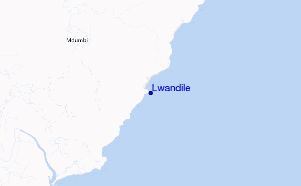
Lwandile surf Forecast / Eastern Cape – Wild Coast / South Africa
- Map Icons:
 Break
Break Live Wave Height (m)
 Live Wind Speed (km/h)
 Surf Rating (10 Max)
 Ocean Swells (m)
- Wind Speed (km/h)
How big are the waves at Lwandile today?
The current surf forecast for Lwandile at 4PM is: 1.4m 13s primary swell from a South-southwest direction and 0.7m 7s secondary swell from a East direction, 0.9m 7s secondary swell from a South-southwest direction (forecast issued at 01:00pm April 25). The wind direction is predicted to be cross-offshore and the swell rating is 4.
| Time (SAST) & Date | Wave Height | Wave Period |
|---|---|---|
| Morning (25 Apr) | 4.5ft (1.4m) | 13s |
| Afternoon (25 Apr) | 4.5ft (1.4m) | 13s |
| Evening (25 Apr) | 4.5ft (1.4m) | 12s |
Table - waves today at Lwandile. (Swell directed towards the surf break)
Thursday 25 | Friday 26 | Saturday 27 | Sunday 28 | Monday 29 | Tuesday 30 | Wednesday 01 | Thursday 02 | |||||||||||||||||||||||||||||||||||||||||||||||||||||
| 11 AM | 2 PM | 5 PM | 8 PM | 11 PM | 2 AM | 5 AM | 8 AM | 11 AM | 2 PM | 5 PM | 8 PM | 11 PM | 2 AM | 5 AM | 8 AM | 11 AM | 2 PM | 5 PM | 8 PM | 11 PM | 2 AM | 5 AM | 8 AM | 11 AM | 2 PM | 5 PM | 8 PM | 11 PM | 2 AM | 5 AM | 8 AM | 11 AM | 2 PM | 5 PM | 8 PM | 11 PM | 2 AM | 5 AM | 8 AM | 11 AM | 2 PM | 5 PM | 8 PM | 11 PM | 2 AM | 5 AM | 8 AM | 11 AM | 2 PM | 5 PM | 8 PM | 11 PM | 2 AM | 5 AM | 8 AM | 11 AM | 2 PM | 5 PM | 8 PM | |
Rating (10 max) | ||||||||||||||||||||||||||||||||||||||||||||||||||||||||||||
Swell Height Map |    |    |    |    |   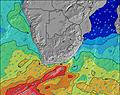 |  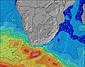 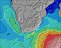 |  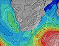 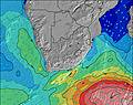 |  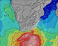 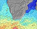 | ||||||||||||||||||||||||||||||||||||||||||||||||||||
| Wave Height (m) & direction (?) | ||||||||||||||||||||||||||||||||||||||||||||||||||||||||||||
| Period(s) (?) | 13 | 13 | 13 | 12 | 12 | 12 | 12 | 12 | 12 | 11 | 11 | 11 | 11 | 11 | 8 | 8 | 8 | 8 | 8 | 18 | 17 | 16 | 16 | 16 | 15 | 15 | 7 | 7 | 7 | 8 | 8 | 8 | 8 | 8 | 8 | 8 | 14 | 14 | 20 | 19 | 18 | 18 | 17 | 17 | 16 | 16 | 15 | 14 | 14 | 13 | 13 | 13 | 12 | 12 | 12 | 12 | 12 | 12 | 12 | 12 |
Wave (?)Graph | ||||||||||||||||||||||||||||||||||||||||||||||||||||||||||||
| Energy (?) | 608 | 599 | 775 | 608 | 589 | 503 | 294 | 177 | 171 | 157 | 151 | 151 | 82 | 223 | 169 | 191 | 190 | 186 | 205 | 246 | 475 | 412 | 397 | 377 | 275 | 272 | 306 | 358 | 666 | 532 | 408 | 429 | 441 | 508 | 488 | 488 | 262 | 233 | 404 | 722 | 1086 | 1190 | 1124 | 1237 | 1029 | 1121 | 1019 | 1206 | 1106 | 929 | 878 | 659 | 618 | 672 | 565 | 636 | 714 | 714 | 776 | 749 |
Wind (km/h) | ||||||||||||||||||||||||||||||||||||||||||||||||||||||||||||
| Wind State (?) onshore cross-onshore cross-shore cross-offshore offshore glassy | cross- off | cross- off | cross- off | off | off | off | off | off | cross- off | cross- off | cross- off | cross | cross- on | cross | cross- on | on | on | on | on | on | cross- on | cross- on | cross- on | cross- on | on | on | on | cross- on | cross- on | cross- on | cross- on | cross- on | on | on | on | cross- off | cross | cross- off | off | cross- off | cross- off | cross | cross- off | off | off | off | off | off | cross- off | cross- off | cross- off | cross- on | glass | glass | on | on | on | on | on | cross- on |
High Tide / height (m) | 4:31PM 1.56 | 4:41AM 1.65 | 4:59PM 1.51 | 5:10AM 1.58 | 5:29PM 1.44 | 5:41AM 1.49 | 6:04PM 1.35 | 6:19AM 1.38 | 6:50PM 1.24 | 7:09AM 1.24 | 8:02PM 1.14 | 8:34AM 1.11 | 10:05PM 1.12 | 10:47AM 1.10 | ||||||||||||||||||||||||||||||||||||||||||||||
Low Tide / height (m) | 10:26AM 0.07 | 10:30PM 0.13 | 10:53AM 0.11 | 10:59PM 0.18 | 11:23AM 0.17 | 11:30PM 0.26 | 11:56AM 0.27 | 12:06AM 0.37 | 12:38PM 0.38 | 12:54AM 0.50 | 1:36PM 0.50 | 2:13AM 0.63 | 3:12PM 0.57 | 4:28AM 0.65 | 5:06PM 0.53 | |||||||||||||||||||||||||||||||||||||||||||||
Thursday 25 | Friday 26 | Saturday 27 | Sunday 28 | Monday 29 | Tuesday 30 | Wednesday 01 | Thursday 02 | |||||||||||||||||||||||||||||||||||||||||||||||||||||
| Sunrise | - | - | - | - | - | - | - | 6:31 | - | - | - | - | - | - | - | 6:31 | - | - | - | - | - | - | - | 6:31 | - | - | - | - | - | - | - | 6:33 | - | - | - | - | - | - | - | 6:33 | - | - | - | - | - | - | - | 6:33 | - | - | - | - | - | - | - | 6:35 | - | - | - | - |
| Sunset | - | - | 5:30 | - | - | - | - | - | - | - | 5:29 | - | - | - | - | - | - | - | 5:28 | - | - | - | - | - | - | - | 5:27 | - | - | - | - | - | - | - | 5:25 | - | - | - | - | - | - | - | 5:24 | - | - | - | - | - | - | - | 5:23 | - | - | - | - | - | - | - | 5:22 | - |
Rain (mm) | - | - | - | - | - | - | - | - | - | 1 | 2 | 2 | 2 | 1 | - | - | - | - | - | - | - | - | - | - | - | - | - | - | - | - | - | - | - | - | - | - | 1 | - | - | - | - | - | - | - | - | - | - | - | - | - | - | - | 1 | 1 | 1 | 2 | 1 | - | - | - |
| Temp. °C | 23 | 22 | 22 | 21 | 20 | 20 | 20 | 19 | 21 | 21 | 21 | 20 | 20 | 20 | 20 | 20 | 21 | 22 | 21 | 21 | 19 | 18 | 17 | 17 | 20 | 23 | 22 | 21 | 21 | 20 | 20 | 21 | 25 | 25 | 23 | 23 | 22 | 21 | 21 | 21 | 26 | 24 | 22 | 21 | 19 | 18 | 18 | 18 | 22 | 22 | 21 | 20 | 19 | 19 | 18 | 18 | 20 | 21 | 20 | 20 |
| Feels °C (?) | 22 | 21 | 21 | 21 | 19 | 18 | 18 | 16 | 18 | 19 | 20 | 19 | 19 | 19 | 20 | 20 | 20 | 20 | 18 | 18 | 17 | 16 | 15 | 14 | 16 | 20 | 19 | 19 | 20 | 19 | 19 | 19 | 24 | 24 | 24 | 23 | 23 | 21 | 20 | 19 | 23 | 22 | 21 | 19 | 16 | 16 | 15 | 15 | 17 | 16 | 17 | 21 | 20 | 20 | 18 | 17 | 16 | 16 | 15 | 15 |
FREE! Surf-Forecast.com widget for your website
The surf report / weather widget below is available to embed on third party websites free of charge and provides a summary of our Lwandile surf forecast. Simply grab the html code snippet that we provide and paste it into your own site. You can choose your preferred language and metric/imperial units for the surf forecast feed to suit users of your site. Click here to get the code.


 Nearest