

- Forecast
- Maps
- Live
- Weather State
- Spot Information
Dooagh Surf Forecast
/ Mayo and Achill Island (14 surf breaks) /
Surf Forecasts
Beach
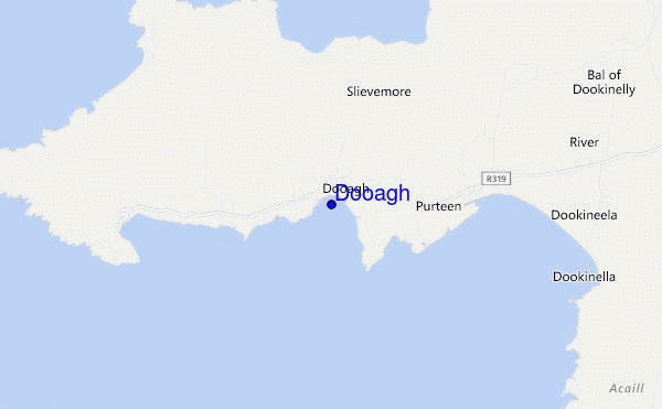
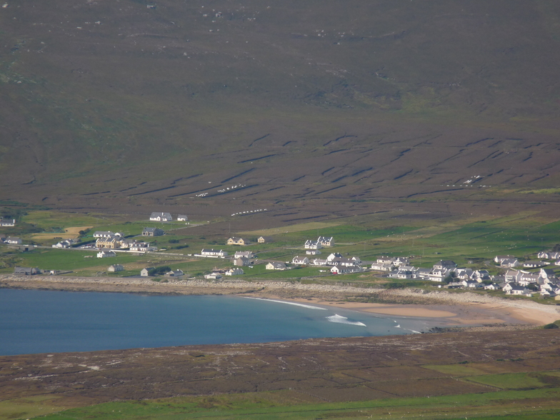
Dooagh surf Forecast / Mayo and Achill Island / Ireland
48hr Weather and Surf, issued 6 pm Wednesday 24 Apr 2024 IST
Forecast update in hr min s Update imminent
Dooagh surf forecast is for near shore open water. Breaking waves will often be smaller at less exposed spots.
Today's Dooagh sea temperature is 11.1°C (Statistics for 24 Apr 1981-2005 - mean: 10.4 °C max: 11.9 °C min: 9.3 °C)
- Map Icons:
 Break
Break Live Wave Height (m)
 Live Wind Speed (km/h)
 Surf Rating (10 Max)
 Ocean Swells (m)
- Wind Speed (km/h)
Dooagh surf forecast is for near shore open water. Breaking waves will often be smaller at less exposed spots.
Today's Dooagh sea temperature is 11.1°C (Statistics for 24 Apr 1981-2005 - mean: 10.4 °C max: 11.9 °C min: 9.3 °C)
How big are the waves at Dooagh today?
The current surf forecast for Dooagh at 1AM is: 0.6m 8s primary swell from a West-southwest direction (forecast issued at 06:00pm April 24). An open ocean swell of 0.3m 5s is not directed at the surf break. The wind direction is predicted to be cross-shore.
| Time (IST) & Date | Wave Height | Wave Period |
|---|---|---|
| Morning (25 Apr) | 2ft (0.6m) | 8s |
| Afternoon (25 Apr) | 2.5ft (0.8m) | 8s |
| Evening (25 Apr) | 6.5ft (2.0m) | 9s |
Table - waves today at Dooagh. (Swell directed towards the surf break)
Updates in hr min s Update imminent
Wednesday 24 | Thursday 25 | Friday 26 | Saturday 27 | Sunday 28 | Monday 29 | Tuesday 30 | Wednesday 01 | Thu 02 | ||||||||||||||||||||||||||||||||||||||||||||||||||||
| 4 PM | 7 PM | 10 PM | 1 AM | 4 AM | 7 AM | 10 AM | 1 PM | 4 PM | 7 PM | 10 PM | 1 AM | 4 AM | 7 AM | 10 AM | 1 PM | 4 PM | 7 PM | 10 PM | 1 AM | 4 AM | 7 AM | 10 AM | 1 PM | 4 PM | 7 PM | 10 PM | 1 AM | 4 AM | 7 AM | 10 AM | 1 PM | 4 PM | 7 PM | 10 PM | 1 AM | 4 AM | 7 AM | 10 AM | 1 PM | 4 PM | 7 PM | 10 PM | 1 AM | 4 AM | 7 AM | 10 AM | 1 PM | 4 PM | 7 PM | 10 PM | 1 AM | 4 AM | 7 AM | 10 AM | 1 PM | 4 PM | 7 PM | 10 PM | 1 AM | |
Rating (10 max) | ||||||||||||||||||||||||||||||||||||||||||||||||||||||||||||
Swell Height Map |    |    |    |    |  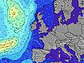 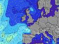 |  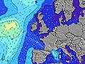 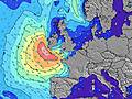 |  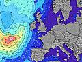 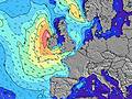 |  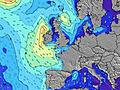 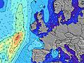 | 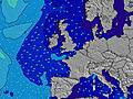 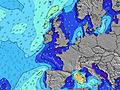 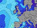 | |||||||||||||||||||||||||||||||||||||||||||||||||||
| Wave Height (m) & direction (?) | ||||||||||||||||||||||||||||||||||||||||||||||||||||||||||||
| Period(s) (?) | 9 | 9 | 8 | 8 | 8 | 8 | 15 | 15 | 8 | 8 | 10 | 10 | 11 | 11 | 11 | 12 | 13 | 12 | 12 | 12 | 11 | 11 | 11 | 10 | 10 | 10 | 10 | 9 | 9 | 9 | 9 | 8 | 8 | 8 | 8 | 8 | 8 | 7 | 7 | 12 | 7 | 11 | 11 | 11 | 7 | 8 | 12 | 11 | 11 | 10 | 10 | 10 | 10 | 9 | 9 | 9 | 9 | 8 | 8 | 8 |
Wave (?)Graph | ||||||||||||||||||||||||||||||||||||||||||||||||||||||||||||
| Energy (?) | 70 | 67 | 62 | 45 | 44 | 43 | 35 | 34 | 75 | 364 | 782 | 937 | 1029 | 969 | 1042 | 1082 | 1211 | 992 | 768 | 639 | 430 | 356 | 292 | 208 | 163 | 160 | 159 | 146 | 116 | 106 | 84 | 96 | 113 | 138 | 159 | 181 | 157 | 136 | 124 | 134 | 125 | 195 | 112 | 235 | 433 | 902 | 3563 | 2403 | 1763 | 1473 | 1645 | 1251 | 638 | 470 | 378 | 307 | 207 | 147 | 120 | 84 |
Wind (km/h) | ||||||||||||||||||||||||||||||||||||||||||||||||||||||||||||
| Wind State (?) onshore cross-onshore cross-shore cross-offshore offshore glassy | cross- off | cross- off | cross- off | cross | cross- off | cross- off | glass | glass | cross- off | off | off | off | off | off | off | cross- off | cross- off | cross- off | off | off | off | off | off | cross- off | cross- off | cross- off | cross- off | cross- off | cross- off | cross | cross- on | on | on | cross- on | on | on | on | cross- on | on | on | cross- on | cross- on | cross- on | cross- off | cross- off | off | cross- off | cross- off | cross- off | cross- off | cross- off | cross- off | cross- off | off | off | off | off | off | off | off |
High Tide / height (m) | 6:55PM 3.60 | 7:09AM 3.47 | 7:24PM 3.58 | 7:41AM 3.38 | 7:55PM 3.51 | 8:15AM 3.24 | 8:29PM 3.39 | 8:54AM 3.07 | 9:09PM 3.24 | 9:40AM 2.88 | 9:57PM 3.08 | 10:41AM 2.70 | 11:01PM 2.95 | 12:02PM 2.61 | 12:20AM 2.91 | |||||||||||||||||||||||||||||||||||||||||||||
Low Tide / height (m) | 12:59AM 0.41 | 1:09PM 0.41 | 1:30AM 0.43 | 1:39PM 0.51 | 2:03AM 0.51 | 2:10PM 0.66 | 2:38AM 0.64 | 2:46PM 0.83 | 3:21AM 0.80 | 3:29PM 1.03 | 4:15AM 0.96 | 4:25PM 1.23 | 5:30AM 1.05 | 5:48PM 1.38 | ||||||||||||||||||||||||||||||||||||||||||||||
Wednesday 24 | Thursday 25 | Friday 26 | Saturday 27 | Sunday 28 | Monday 29 | Tuesday 30 | Wednesday 01 | Thu 02 | ||||||||||||||||||||||||||||||||||||||||||||||||||||
| Sunrise | - | - | - | - | - | 6:16 | - | - | - | - | - | - | - | 6:13 | - | - | - | - | - | - | - | 6:11 | - | - | - | - | - | - | - | 6:09 | - | - | - | - | - | - | - | 6:07 | - | - | - | - | - | - | - | 6:05 | - | - | - | - | - | - | - | 6:03 | - | - | - | - | - | - |
| Sunset | - | 9:00 | - | - | - | - | - | - | - | 9:00 | - | - | - | - | - | - | - | 9:02 | - | - | - | - | - | - | - | 9:05 | - | - | - | - | - | - | - | 9:07 | - | - | - | - | - | - | - | 9:08 | - | - | - | - | - | - | - | 9:10 | - | - | - | - | - | - | - | 9:12 | - | - |
Rain (mm) | - | - | - | - | - | - | - | - | - | - | - | - | - | - | - | - | - | - | - | - | - | - | - | - | - | - | - | - | - | - | - | - | - | - | - | 2 | 2 | 1 | 1 | - | - | - | - | - | - | 1 | 1 | - | - | - | - | 2 | 3 | 2 | 1 | - | - | - | - | - |
| Temp. °C | 9 | 9 | 9 | 9 | 9 | 9 | 9 | 9 | 9 | 9 | 8 | 7 | 7 | 7 | 9 | 9 | 9 | 9 | 8 | 7 | 7 | 7 | 8 | 9 | 9 | 9 | 9 | 8 | 8 | 8 | 9 | 9 | 10 | 10 | 10 | 10 | 9 | 10 | 10 | 10 | 10 | 10 | 10 | 9 | 8 | 8 | 11 | 12 | 14 | 12 | 11 | 10 | 10 | 9 | 9 | 10 | 10 | 11 | 10 | 10 |
| Feels °C (?) | 5 | 5 | 6 | 7 | 6 | 6 | 7 | 7 | 5 | 2 | 1 | 0 | 1 | 1 | 2 | 2 | 1 | 1 | 1 | 1 | 3 | 3 | 5 | 4 | 2 | 3 | 5 | 5 | 5 | 4 | 6 | 5 | 6 | 6 | 6 | 6 | 5 | 6 | 3 | 3 | 4 | 5 | 5 | 4 | 2 | 2 | 3 | 4 | 7 | 5 | 5 | 6 | 7 | 6 | 6 | 8 | 8 | 9 | 6 | 7 |
FREE! Surf-Forecast.com widget for your website
The surf report / weather widget below is available to embed on third party websites free of charge and provides a summary of our Dooagh surf forecast. Simply grab the html code snippet that we provide and paste it into your own site. You can choose your preferred language and metric/imperial units for the surf forecast feed to suit users of your site. Click here to get the code.


 Nearest